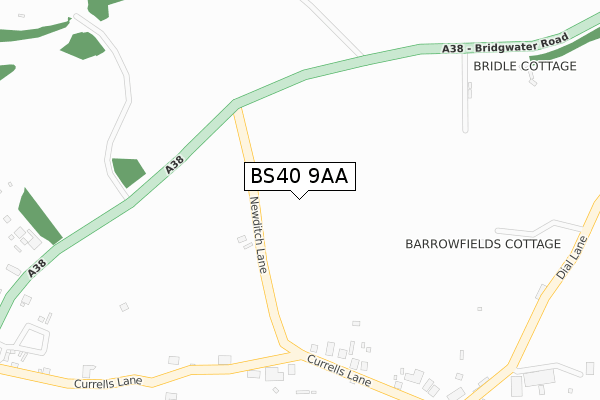
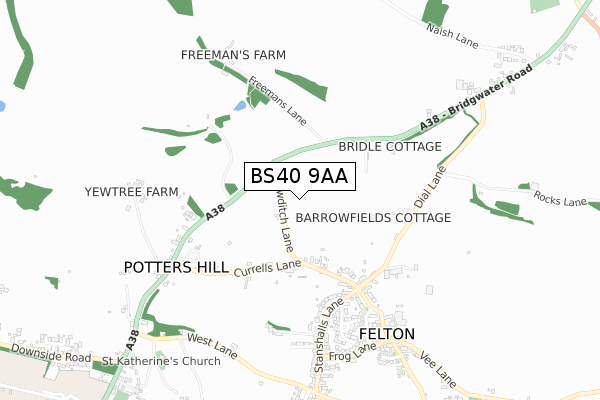
BS40 9AA is located in the Winford electoral ward, within the unitary authority of North Somerset and the English Parliamentary constituency of North Somerset. The Sub Integrated Care Board (ICB) Location is NHS Bristol, North Somerset and South Gloucestershire ICB - 15C and the police force is Avon and Somerset. This postcode has been in use since December 2019.


GetTheData
Source: OS Open Zoomstack (Ordnance Survey)
Licence: Open Government Licence (requires attribution)
Attribution: Contains OS data © Crown copyright and database right 2024
Source: Open Postcode Geo
Licence: Open Government Licence (requires attribution)
Attribution: Contains OS data © Crown copyright and database right 2024; Contains Royal Mail data © Royal Mail copyright and database right 2024; Source: Office for National Statistics licensed under the Open Government Licence v.3.0
| Easting | 352097 |
| Northing | 166312 |
| Latitude | 51.393809 |
| Longitude | -2.689895 |
GetTheData
Source: Open Postcode Geo
Licence: Open Government Licence
| Country | England |
| Postcode District | BS40 |
| ➜ BS40 open data dashboard ➜ See where BS40 is on a map | |
GetTheData
Source: Land Registry Price Paid Data
Licence: Open Government Licence
| Ward | Winford |
| Constituency | North Somerset |
GetTheData
Source: ONS Postcode Database
Licence: Open Government Licence
| May 2021 | Other theft | On or near Newditch Lane | 251m |
| March 2021 | Anti-social behaviour | On or near Newditch Lane | 251m |
| February 2021 | Anti-social behaviour | On or near Newditch Lane | 251m |
| ➜ Get more crime data in our Crime section | |||
GetTheData
Source: data.police.uk
Licence: Open Government Licence
| Currells Lane | Potters Hill | 581m |
| Currells Lane | Potters Hill | 595m |
| Post Office (Upper Town Lane) | Felton | 630m |
| Post Office (Upper Town Lane) | Felton | 647m |
| George And Dragon | Upper Town | 824m |
| Nailsea & Backwell Station | 5.1km |
GetTheData
Source: NaPTAN
Licence: Open Government Licence
| Percentage of properties with Next Generation Access | 100.0% |
| Percentage of properties with Superfast Broadband | 0.0% |
| Percentage of properties with Ultrafast Broadband | 0.0% |
| Percentage of properties with Full Fibre Broadband | 0.0% |
Superfast Broadband is between 30Mbps and 300Mbps
Ultrafast Broadband is > 300Mbps
| Percentage of properties unable to receive 2Mbps | 0.0% |
| Percentage of properties unable to receive 5Mbps | 0.0% |
| Percentage of properties unable to receive 10Mbps | 0.0% |
| Percentage of properties unable to receive 30Mbps | 100.0% |
GetTheData
Source: Ofcom
Licence: Ofcom Terms of Use (requires attribution)
GetTheData
Source: ONS Postcode Database
Licence: Open Government Licence


➜ Get more ratings from the Food Standards Agency
GetTheData
Source: Food Standards Agency
Licence: FSA terms & conditions
| Last Collection | |||
|---|---|---|---|
| Location | Mon-Fri | Sat | Distance |
| Bourton Road | 16:30 | 10:30 | 3,266m |
| Crabtree | 16:15 | 07:30 | 3,487m |
| Dundry (Old Post Office) | 16:15 | 10:15 | 3,701m |
GetTheData
Source: Dracos
Licence: Creative Commons Attribution-ShareAlike
| Facility | Distance |
|---|---|
| Barrow Gurney Cricket Club Hobbs Lane, Barrow Gurney Grass Pitches | 1.3km |
| Bishop Sutton Cricket Club Kingston Lane, Winford Grass Pitches | 1.6km |
| Tall Pines Golf Club Cooks Bridle Path, Backwell, Bristol Golf | 2.5km |
GetTheData
Source: Active Places
Licence: Open Government Licence
| School | Phase of Education | Distance |
|---|---|---|
| Winford Church of England Primary School Winford Church of England Primary School, Felton Lane, Winford, Bristol, BS40 8AD | Primary | 2.2km |
| Flax Bourton Church of England Primary School Station Road, Flax Bourton, Bristol, BS48 1UA | Primary | 3.5km |
| Backwell Church of England Junior School Church Lane, Backwell, North Somerset, Bristol, BS48 3JJ | Primary | 3.6km |
GetTheData
Source: Edubase
Licence: Open Government Licence
The below table lists the International Territorial Level (ITL) codes (formerly Nomenclature of Territorial Units for Statistics (NUTS) codes) and Local Administrative Units (LAU) codes for BS40 9AA:
| ITL 1 Code | Name |
|---|---|
| TLK | South West (England) |
| ITL 2 Code | Name |
| TLK1 | Gloucestershire, Wiltshire and Bath/Bristol area |
| ITL 3 Code | Name |
| TLK12 | Bath and North East Somerset, North Somerset and South Gloucestershire |
| LAU 1 Code | Name |
| E06000024 | North Somerset |
GetTheData
Source: ONS Postcode Directory
Licence: Open Government Licence
The below table lists the Census Output Area (OA), Lower Layer Super Output Area (LSOA), and Middle Layer Super Output Area (MSOA) for BS40 9AA:
| Code | Name | |
|---|---|---|
| OA | E00074454 | |
| LSOA | E01014740 | North Somerset 011D |
| MSOA | E02003075 | North Somerset 011 |
GetTheData
Source: ONS Postcode Directory
Licence: Open Government Licence
| BS40 9XF | Currells Lane | 338m |
| BS40 9XG | Currells Lane | 351m |
| BS40 9YD | Dial Lane | 425m |
| BS40 9UG | Stanshalls Lane | 461m |
| BS40 9YB | Upper Town Lane | 515m |
| BS40 9UQ | Stanshalls Lane | 525m |
| BS40 9XB | Potters Hill | 544m |
| BS40 9UH | Hillview Gardens | 593m |
| BS40 9XZ | Pound Mead | 597m |
| BS40 9UJ | Stanshalls Close | 602m |
GetTheData
Source: Open Postcode Geo; Land Registry Price Paid Data
Licence: Open Government Licence