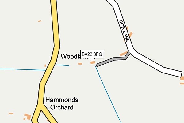
BA22 8FG is located in the Castle Cary electoral ward, within the unitary authority of Somerset and the English Parliamentary constituency of Somerton and Frome. The Sub Integrated Care Board (ICB) Location is NHS Somerset ICB - 11X and the police force is Avon and Somerset. This postcode has been in use since March 2017.


GetTheData
Source: OS OpenMap – Local (Ordnance Survey)
Source: OS VectorMap District (Ordnance Survey)
Licence: Open Government Licence (requires attribution)
| Easting | 360832 |
| Northing | 121306 |
| Latitude | 50.989806 |
| Longitude | -2.559429 |
GetTheData
Source: Open Postcode Geo
Licence: Open Government Licence
| Country | England |
| Postcode District | BA22 |
| ➜ BA22 open data dashboard ➜ See where BA22 is on a map | |
GetTheData
Source: Land Registry Price Paid Data
Licence: Open Government Licence
| Ward | Castle Cary |
| Constituency | Somerton And Frome |
GetTheData
Source: ONS Postcode Database
Licence: Open Government Licence
| January 2022 | Other theft | On or near High Street | 445m |
| ➜ Get more crime data in our Crime section | |||
GetTheData
Source: data.police.uk
Licence: Open Government Licence
| Middle Street (High Street) | Rimpton | 547m |
| High Street (Middle Street) | Rimpton | 560m |
| Post Office | Sandford Orcas | 1,567m |
| Adber Cross | Adber | 1,679m |
| Police House (Camel Street) | Marston Magna | 1,921m |
GetTheData
Source: NaPTAN
Licence: Open Government Licence
GetTheData
Source: ONS Postcode Database
Licence: Open Government Licence


➜ Get more ratings from the Food Standards Agency
GetTheData
Source: Food Standards Agency
Licence: FSA terms & conditions
| Last Collection | |||
|---|---|---|---|
| Location | Mon-Fri | Sat | Distance |
| Hazelgrove Service Station | 16:15 | 12:00 | 4,674m |
| Mudford Post Office | 17:30 | 11:00 | 4,906m |
| South Cadbury | 16:15 | 09:00 | 4,932m |
GetTheData
Source: Dracos
Licence: Creative Commons Attribution-ShareAlike
| Facility | Distance |
|---|---|
| Sandford Orcas Village Hall Sandford Orcas, Sherborne Sports Hall | 1.6km |
| Trent Youngs Primary School Trent, Sherborne Grass Pitches | 3.2km |
| Sherborne Golf Club Higher Clatcombe, Sherborne Golf | 3.3km |
GetTheData
Source: Active Places
Licence: Open Government Licence
| School | Phase of Education | Distance |
|---|---|---|
| Trent Young's CofE Primary School Trent, Sherborne, DT9 4SW | Primary | 3.2km |
| Countess Gytha Primary School West Camel Road, Queen Camel, Yeovil, BA22 7FF | Primary | 3.4km |
| The Gryphon School Bristol Road, Sherborne, DT9 4EQ | Secondary | 4.6km |
GetTheData
Source: Edubase
Licence: Open Government Licence
The below table lists the International Territorial Level (ITL) codes (formerly Nomenclature of Territorial Units for Statistics (NUTS) codes) and Local Administrative Units (LAU) codes for BA22 8FG:
| ITL 1 Code | Name |
|---|---|
| TLK | South West (England) |
| ITL 2 Code | Name |
| TLK2 | Dorset and Somerset |
| ITL 3 Code | Name |
| TLK23 | Somerset CC |
| LAU 1 Code | Name |
| E07000189 | South Somerset |
GetTheData
Source: ONS Postcode Directory
Licence: Open Government Licence
The below table lists the Census Output Area (OA), Lower Layer Super Output Area (LSOA), and Middle Layer Super Output Area (MSOA) for BA22 8FG:
| Code | Name | |
|---|---|---|
| OA | E00148563 | |
| LSOA | E01029165 | South Somerset 006B |
| MSOA | E02006080 | South Somerset 006 |
GetTheData
Source: ONS Postcode Directory
Licence: Open Government Licence
| BA22 8AN | 167m | |
| BA22 8AW | 405m | |
| BA22 8AD | 421m | |
| BA22 8AH | Back Lane | 547m |
| BA22 8AF | 559m | |
| BA22 8AE | Church Lane | 573m |
| BA22 8AG | Daisyfield | 585m |
| BA22 8AQ | 635m | |
| BA22 8AB | 648m | |
| BA22 8AS | Home Farm Lane | 699m |
GetTheData
Source: Open Postcode Geo; Land Registry Price Paid Data
Licence: Open Government Licence