Golders Hill Park - London
Golders Hill Park is located in London (NW11), and offers Outdoor Tennis Courts.
| Address | 21, West Heath Avenue, London, NW11 7QP |
| Management Type | Local Authority (in house) |
| Management Group | Local Authority |
| Owner Type | Local Authority |
| Owner Group | Local Authority |
| Education Phase | Not applicable |
Facilities
| Accessibility | Pay and Play |
| Management Type | Local Authority (in house) |
| Year Built | 1990 |
| Year Refurbished | 2021 |
| Changing Rooms | No |
| Date Record Created | 1st Nov 2017 |
| Date Record Checked | 11th Jul 2023 |
| Opening Times | Dawn To Dusk |
Facility specifics
| Floodlit | No |
| Overmarked | No |
| Surface Type | Macadam |
Disabled access
| Disabled Access | Yes |
| Disabled Parking | Yes |
| Finding/Reaching Entrance | Yes |
| Reception Area | Yes |
| Doorways | Yes |
| Activity Areas | Yes |
| Disabled Toilets | Yes |
| Social Areas | Yes |
| Spectator Areas | Yes |
| Emergency Exits | Yes |
| Closure Date | 1st Apr 2022 |
| Closure Reason | Strategic Review - facility/site not being replaced |
| Accessibility | Sports Club / Community Association |
| Management Type | Local Authority (in house) |
| Year Built | 1990 |
| Changing Rooms | No |
| Date Record Created | 1st Nov 2017 |
| Date Record Checked | 11th Jul 2023 |
| Opening Times | Dawn To Dusk |
Facility specifics
| Floodlit | No |
| Overmarked | No |
| Surface Type | Grass |
Disabled access
| Disabled Access | Yes |
| Disabled Parking | Yes |
| Finding/Reaching Entrance | Yes |
| Reception Area | Yes |
| Doorways | Yes |
| Activity Areas | Yes |
| Disabled Toilets | Yes |
| Social Areas | Yes |
| Spectator Areas | Yes |
| Emergency Exits | Yes |
Contact
Disabled access
Disabled access for Golders Hill Park
| Disabled Access | Yes |
| Disabled Parking | Yes |
| Finding/Reaching Entrance | Yes |
| Reception Area | Yes |
| Doorways | Yes |
| Activity Areas | Yes |
| Disabled Toilets | Yes |
| Social Areas | Yes |
| Spectator Areas | Yes |
| Emergency Exits | Yes |
Where is Golders Hill Park?
8192:htmlspecialchars(): Passing null to parameter #1 ($string) of type string is deprecated
| Sub Building Name | |
8192:htmlspecialchars(): Passing null to parameter #1 ($string) of type string is deprecated
| Building Name | |
| Building Number | 21 |
8192:htmlspecialchars(): Passing null to parameter #1 ($string) of type string is deprecated
| Dependent Thoroughfare | |
| Thoroughfare Name | WEST HEATH AVENUE |
8192:htmlspecialchars(): Passing null to parameter #1 ($string) of type string is deprecated
| Double Dependent Locality | |
8192:htmlspecialchars(): Passing null to parameter #1 ($string) of type string is deprecated
| Dependent Locality | |
| PostTown | LONDON |
| Postcode | NW11 7QP |
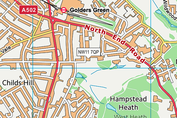
Golders Hill Park on a map

Golders Hill Park geodata
| Easting | 525471.73 |
| Northing | 187014.45 |
| Latitude | 51.568052 |
| Longitude | -0.191064 |
| Local Authority Name | Barnet |
| Local Authority Code | E09000003 |
| Parliamentary Constituency Name | Finchley and Golders Green |
| Parliamentary Constituency Code | E14000703 |
| Region Name | London |
| Region Code | E15000007 |
| Ward Name | Childs Hill |
| Ward Code | E05013631 |
| Output Area Code | E00000707 |
About this data
This data is open data sourced from Active Places Power and licenced under the Active Places Open Data Licence.
| toid | osgb1000004211247 |
| Created On | 1st Nov 2017 |
| Audited On | 11th Jul 2023 |
| Checked On | 11th Jul 2023 |
