Conway Playing Fields - Birkenhead
Conway Playing Fields is located in Birkenhead (CH42).
| Address | Victoria Drive, Birkenhead, CH42 1QX |
| Management Type | Local Authority (in house) |
| Management Group | Local Authority |
| Owner Type | Local Authority |
| Owner Group | Local Authority |
| Education Phase | Not applicable |
Facilities
| Accessibility | Pay and Play |
| Management Type | Local Authority (in house) |
| Changing Rooms | No |
| Date Record Checked | 3rd Jul 2023 |
Opening times
| Access description | Sports Club / Community Association |
|---|
| Opening time | 09:00 |
| Closing time | 17:00 |
| Period open for | Weekend |
| |
| Access description | Pay and Play |
|---|
| Opening time | 09:00 |
| Closing time | 17:00 |
| Period open for | Monday-Friday |
Facility specifics
Disabled access
| Disabled Access | Yes |
| Finding/Reaching Entrance | Yes |
| Activity Areas | Yes |
| Social Areas | Yes |
| Spectator Areas | Yes |
| Accessibility | Pay and Play |
| Management Type | Local Authority (in house) |
| Changing Rooms | No |
| Date Record Checked | 3rd Jul 2023 |
Opening times
| Access description | Pay and Play |
|---|
| Opening time | 09:00 |
| Closing time | 17:00 |
| Period open for | Monday-Friday |
| |
| Access description | Sports Club / Community Association |
|---|
| Opening time | 09:00 |
| Closing time | 17:00 |
| Period open for | Weekend |
Facility specifics
Disabled access
| Disabled Access | Yes |
| Finding/Reaching Entrance | Yes |
| Activity Areas | Yes |
| Social Areas | Yes |
| Spectator Areas | Yes |
Contact
Disabled access
Disabled access for Conway Playing Fields
| Disabled Access | Yes |
| Finding/Reaching Entrance | Yes |
| Activity Areas | Yes |
| Social Areas | Yes |
| Spectator Areas | Yes |
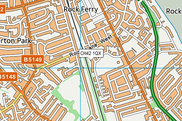
Where is Conway Playing Fields?
8192:htmlspecialchars(): Passing null to parameter #1 ($string) of type string is deprecated
8192:htmlspecialchars(): Passing null to parameter #1 ($string) of type string is deprecated
8192:htmlspecialchars(): Passing null to parameter #1 ($string) of type string is deprecated
8192:htmlspecialchars(): Passing null to parameter #1 ($string) of type string is deprecated
8192:htmlspecialchars(): Passing null to parameter #1 ($string) of type string is deprecated
| Sub Building Name | |
| Building Name | |
| Building Number | 0 |
| Dependent Thoroughfare | |
| Thoroughfare Name | VICTORIA DRIVE |
| Double Dependent Locality | |
| Dependent Locality | |
| PostTown | BIRKENHEAD |
| Postcode | CH42 1QX |
Conway Playing Fields on a map

Conway Playing Fields geodata
| Easting | 333159.37 |
| Northing | 386035.26 |
| Latitude | 53.366939 |
| Longitude | -3.005966 |
| Local Authority Name | Wirral |
| Local Authority Code | E08000015 |
| Parliamentary Constituency Name | Birkenhead |
| Parliamentary Constituency Code | E14000559 |
| Region Name | North West |
| Region Code | E15000002 |
| Ward Name | Rock Ferry |
| Ward Code | E05000971 |
| Output Area Code | E00036946 |
About this data
This data is open data sourced from Active Places Power and licenced under the Active Places Open Data Licence.
| Created On | 28th Sep 2005 |
| Audited On | 3rd Jul 2023 |
| Checked On | 4th Jul 2023 |
