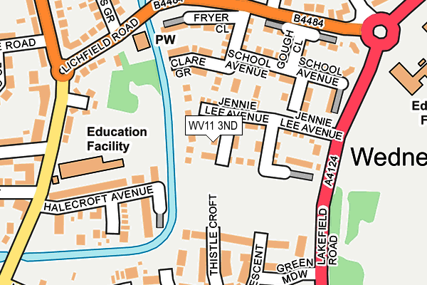
WV11 3ND is located in the Wednesfield South electoral ward, within the metropolitan district of Wolverhampton and the English Parliamentary constituency of Wolverhampton North East. The Sub Integrated Care Board (ICB) Location is NHS Black Country ICB - D2P2L and the police force is West Midlands. This postcode has been in use since February 2017.


GetTheData
Source: OS OpenMap – Local (Ordnance Survey)
Source: OS VectorMap District (Ordnance Survey)
Licence: Open Government Licence (requires attribution)
| Easting | 394918 |
| Northing | 300506 |
| Latitude | 52.602332 |
| Longitude | -2.076463 |
GetTheData
Source: Open Postcode Geo
Licence: Open Government Licence
| Country | England |
| Postcode District | WV11 |
➜ See where WV11 is on a map ➜ Where is Wolverhampton? | |
GetTheData
Source: Land Registry Price Paid Data
Licence: Open Government Licence
| Ward | Wednesfield South |
| Constituency | Wolverhampton North East |
GetTheData
Source: ONS Postcode Database
Licence: Open Government Licence
9, WALTON HALL GARDENS, WOLVERHAMPTON, WV11 3ND 2017 29 JUN £272,500 |
12, WALTON HALL GARDENS, WOLVERHAMPTON, WV11 3ND 2017 29 JUN £219,500 |
10, WALTON HALL GARDENS, WOLVERHAMPTON, WV11 3ND 2017 29 JUN £219,950 |
8, WALTON HALL GARDENS, WOLVERHAMPTON, WV11 3ND 2017 29 JUN £271,500 |
7, WALTON HALL GARDENS, WOLVERHAMPTON, WV11 3ND 2017 26 MAY £217,950 |
GetTheData
Source: HM Land Registry Price Paid Data
Licence: Contains HM Land Registry data © Crown copyright and database right 2025. This data is licensed under the Open Government Licence v3.0.
| Jennie Lee Centre (Lichfield Rd) | March End | 197m |
| Lewis Grove (Lichfield Rd) | Wednesfield | 202m |
| Jennie Lee Centre (Lichfield Rd) | March End | 204m |
| Tithe Rd (Lichfield Rd) | Wednesfield | 216m |
| Lewis Grove (Lichfield Rd) | Wednesfield | 217m |
| Wolverhampton Station | 3.3km |
| Bloxwich North Station | 4.7km |
| Bloxwich Station | 4.7km |
GetTheData
Source: NaPTAN
Licence: Open Government Licence
| Percentage of properties with Next Generation Access | 100.0% |
| Percentage of properties with Superfast Broadband | 100.0% |
| Percentage of properties with Ultrafast Broadband | 100.0% |
| Percentage of properties with Full Fibre Broadband | 100.0% |
Superfast Broadband is between 30Mbps and 300Mbps
Ultrafast Broadband is > 300Mbps
| Median download speed | 5.3Mbps |
| Average download speed | 4.9Mbps |
| Maximum download speed | 7.32Mbps |
| Median upload speed | 0.8Mbps |
| Average upload speed | 0.8Mbps |
| Maximum upload speed | 0.99Mbps |
| Percentage of properties unable to receive 2Mbps | 0.0% |
| Percentage of properties unable to receive 5Mbps | 0.0% |
| Percentage of properties unable to receive 10Mbps | 0.0% |
| Percentage of properties unable to receive 30Mbps | 0.0% |
GetTheData
Source: Ofcom
Licence: Ofcom Terms of Use (requires attribution)
GetTheData
Source: ONS Postcode Database
Licence: Open Government Licence

➜ Get more ratings from the Food Standards Agency
GetTheData
Source: Food Standards Agency
Licence: FSA terms & conditions
| Last Collection | |||
|---|---|---|---|
| Location | Mon-Fri | Sat | Distance |
| Lichfield Road | 17:15 | 12:00 | 236m |
| Wednesfield Post Office | 17:00 | 12:15 | 450m |
| Perry Hall Post Office | 16:45 | 12:00 | 1,173m |
GetTheData
Source: Dracos
Licence: Creative Commons Attribution-ShareAlike
The below table lists the International Territorial Level (ITL) codes (formerly Nomenclature of Territorial Units for Statistics (NUTS) codes) and Local Administrative Units (LAU) codes for WV11 3ND:
| ITL 1 Code | Name |
|---|---|
| TLG | West Midlands (England) |
| ITL 2 Code | Name |
| TLG3 | West Midlands |
| ITL 3 Code | Name |
| TLG39 | Wolverhampton |
| LAU 1 Code | Name |
| E08000031 | Wolverhampton |
GetTheData
Source: ONS Postcode Directory
Licence: Open Government Licence
The below table lists the Census Output Area (OA), Lower Layer Super Output Area (LSOA), and Middle Layer Super Output Area (MSOA) for WV11 3ND:
| Code | Name | |
|---|---|---|
| OA | E00053323 | |
| LSOA | E01010564 | Wolverhampton 012C |
| MSOA | E02002160 | Wolverhampton 012 |
GetTheData
Source: ONS Postcode Directory
Licence: Open Government Licence
| WV11 3LZ | Jennie Lee Avenue | 52m |
| WV11 3JA | Asheridge Close | 87m |
| WV11 3PJ | Wards Bridge Drive | 130m |
| WV11 3NB | Tomkys Gardens | 145m |
| WV11 1TS | Halecroft Avenue | 152m |
| WV11 3XD | Thistle Croft | 163m |
| WV11 3JD | Fryer Close | 168m |
| WV11 3NA | School Avenue | 179m |
| WV11 1TP | Lichfield Road | 190m |
| WV11 3LF | Gough Close | 190m |
GetTheData
Source: Open Postcode Geo; Land Registry Price Paid Data
Licence: Open Government Licence