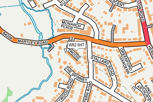
WR2 6HT is located in the St Clement electoral ward, within the local authority district of Worcester and the English Parliamentary constituency of Worcester. The Sub Integrated Care Board (ICB) Location is NHS Herefordshire and Worcestershire ICB - 18C and the police force is West Mercia. This postcode has been in use since July 2017.


GetTheData
Source: OS OpenMap – Local (Ordnance Survey)
Source: OS VectorMap District (Ordnance Survey)
Licence: Open Government Licence (requires attribution)
| Easting | 383310 |
| Northing | 256073 |
| Latitude | 52.202642 |
| Longitude | -2.245627 |
GetTheData
Source: Open Postcode Geo
Licence: Open Government Licence
| Country | England |
| Postcode District | WR2 |
➜ See where WR2 is on a map ➜ Where is Worcester? | |
GetTheData
Source: Land Registry Price Paid Data
Licence: Open Government Licence
| Ward | St Clement |
| Constituency | Worcester |
GetTheData
Source: ONS Postcode Database
Licence: Open Government Licence
1A, HERONWOOD CLOSE, WORCESTER, WR2 6HT 2018 31 AUG £265,000 |
GetTheData
Source: HM Land Registry Price Paid Data
Licence: Contains HM Land Registry data © Crown copyright and database right 2025. This data is licensed under the Open Government Licence v3.0.
| Martley Road Shops (Martley Road) | Henwick Park | 80m |
| Martley Road Shops (B4204) | Henwick Park | 115m |
| Martley Road Shops (Monarch Drive) | Henwick Park | 123m |
| Fern Road | Henwick Park | 212m |
| Himbleton House (Himbleton Road) | Henwick Park | 265m |
| Worcester Foregate Street Station | 1.8km |
| Worcester Shrub Hill Station | 2.6km |
GetTheData
Source: NaPTAN
Licence: Open Government Licence
| Percentage of properties with Next Generation Access | 100.0% |
| Percentage of properties with Superfast Broadband | 100.0% |
| Percentage of properties with Ultrafast Broadband | 100.0% |
| Percentage of properties with Full Fibre Broadband | 0.0% |
Superfast Broadband is between 30Mbps and 300Mbps
Ultrafast Broadband is > 300Mbps
| Percentage of properties unable to receive 2Mbps | 0.0% |
| Percentage of properties unable to receive 5Mbps | 0.0% |
| Percentage of properties unable to receive 10Mbps | 0.0% |
| Percentage of properties unable to receive 30Mbps | 0.0% |
GetTheData
Source: Ofcom
Licence: Ofcom Terms of Use (requires attribution)
GetTheData
Source: ONS Postcode Database
Licence: Open Government Licence


➜ Get more ratings from the Food Standards Agency
GetTheData
Source: Food Standards Agency
Licence: FSA terms & conditions
| Last Collection | |||
|---|---|---|---|
| Location | Mon-Fri | Sat | Distance |
| Monarch Drive | 16:45 | 11:30 | 91m |
| River View Close | 16:45 | 11:30 | 510m |
| Training College Henwick Road | 17:00 | 11:30 | 520m |
GetTheData
Source: Dracos
Licence: Creative Commons Attribution-ShareAlike
The below table lists the International Territorial Level (ITL) codes (formerly Nomenclature of Territorial Units for Statistics (NUTS) codes) and Local Administrative Units (LAU) codes for WR2 6HT:
| ITL 1 Code | Name |
|---|---|
| TLG | West Midlands (England) |
| ITL 2 Code | Name |
| TLG1 | Herefordshire, Worcestershire and Warwickshire |
| ITL 3 Code | Name |
| TLG12 | Worcestershire CC |
| LAU 1 Code | Name |
| E07000237 | Worcester |
GetTheData
Source: ONS Postcode Directory
Licence: Open Government Licence
The below table lists the Census Output Area (OA), Lower Layer Super Output Area (LSOA), and Middle Layer Super Output Area (MSOA) for WR2 6HT:
| Code | Name | |
|---|---|---|
| OA | E00164828 | |
| LSOA | E01032317 | Worcester 006D |
| MSOA | E02006739 | Worcester 006 |
GetTheData
Source: ONS Postcode Directory
Licence: Open Government Licence
| WR2 6HL | The Spinney | 63m |
| WR2 6HJ | Fern Road | 69m |
| WR2 6HH | Martley Road | 82m |
| WR2 6EU | Monarch Drive | 117m |
| WR2 6HN | Bracken Close | 134m |
| WR2 6BH | Stallard Road | 137m |
| WR2 6HG | Martley Road | 165m |
| WR2 6HR | Fern Road | 168m |
| WR2 6HW | Honeywood Road | 170m |
| WR2 6BQ | Himbleton Road | 179m |
GetTheData
Source: Open Postcode Geo; Land Registry Price Paid Data
Licence: Open Government Licence