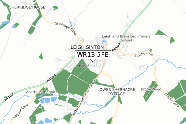
WR13 5FE is located in the Alfrick, Leigh & Rushwick electoral ward, within the local authority district of Malvern Hills and the English Parliamentary constituency of West Worcestershire. The Sub Integrated Care Board (ICB) Location is NHS Herefordshire and Worcestershire ICB - 18C and the police force is West Mercia. This postcode has been in use since February 2018.


GetTheData
Source: OS Open Zoomstack (Ordnance Survey)
Licence: Open Government Licence (requires attribution)
Attribution: Contains OS data © Crown copyright and database right 2025
Source: Open Postcode Geo
Licence: Open Government Licence (requires attribution)
Attribution: Contains OS data © Crown copyright and database right 2025; Contains Royal Mail data © Royal Mail copyright and database right 2025; Source: Office for National Statistics licensed under the Open Government Licence v.3.0
| Easting | 378073 |
| Northing | 250629 |
| Latitude | 52.153513 |
| Longitude | -2.321902 |
GetTheData
Source: Open Postcode Geo
Licence: Open Government Licence
| Country | England |
| Postcode District | WR13 |
➜ See where WR13 is on a map ➜ Where is Leigh Sinton? | |
GetTheData
Source: Land Registry Price Paid Data
Licence: Open Government Licence
| Ward | Alfrick, Leigh & Rushwick |
| Constituency | West Worcestershire |
GetTheData
Source: ONS Postcode Database
Licence: Open Government Licence
2022 8 JUL £346,200 |
17, NORWAY CLOSE, LEIGH SINTON, MALVERN, WR13 5FE 2018 30 APR £323,000 |
2018 29 MAR £329,950 |
21, NORWAY CLOSE, LEIGH SINTON, MALVERN, WR13 5FE 2018 27 FEB £474,950 |
GetTheData
Source: HM Land Registry Price Paid Data
Licence: Contains HM Land Registry data © Crown copyright and database right 2025. This data is licensed under the Open Government Licence v3.0.
| Royal Oak (Malvern Road) | Leigh Sinton | 186m |
| Royal Oak (Malvern) | Leigh Sinton | 198m |
| Sherridge Road (A4103) | Leigh Sinton | 213m |
| Sherridge Road (A4103) | Leigh Sinton | 248m |
| Somers Close (A4103) | Leigh Sinton | 319m |
| Malvern Link Station | 3.1km |
| Great Malvern Station | 4.9km |
GetTheData
Source: NaPTAN
Licence: Open Government Licence
| Percentage of properties with Next Generation Access | 100.0% |
| Percentage of properties with Superfast Broadband | 100.0% |
| Percentage of properties with Ultrafast Broadband | 100.0% |
| Percentage of properties with Full Fibre Broadband | 100.0% |
Superfast Broadband is between 30Mbps and 300Mbps
Ultrafast Broadband is > 300Mbps
| Median download speed | 360.0Mbps |
| Average download speed | 360.0Mbps |
| Maximum download speed | 360.00Mbps |
| Median upload speed | 360.0Mbps |
| Average upload speed | 360.0Mbps |
| Maximum upload speed | 360.00Mbps |
| Percentage of properties unable to receive 2Mbps | 0.0% |
| Percentage of properties unable to receive 5Mbps | 0.0% |
| Percentage of properties unable to receive 10Mbps | 0.0% |
| Percentage of properties unable to receive 30Mbps | 0.0% |
GetTheData
Source: Ofcom
Licence: Ofcom Terms of Use (requires attribution)
GetTheData
Source: ONS Postcode Database
Licence: Open Government Licence


➜ Get more ratings from the Food Standards Agency
GetTheData
Source: Food Standards Agency
Licence: FSA terms & conditions
| Last Collection | |||
|---|---|---|---|
| Location | Mon-Fri | Sat | Distance |
| Leigh Sinton P.o. | 16:30 | 09:45 | 229m |
| Lower Interfield | 16:00 | 07:00 | 873m |
| Suffield Close | 16:00 | 08:00 | 1,501m |
GetTheData
Source: Dracos
Licence: Creative Commons Attribution-ShareAlike
The below table lists the International Territorial Level (ITL) codes (formerly Nomenclature of Territorial Units for Statistics (NUTS) codes) and Local Administrative Units (LAU) codes for WR13 5FE:
| ITL 1 Code | Name |
|---|---|
| TLG | West Midlands (England) |
| ITL 2 Code | Name |
| TLG1 | Herefordshire, Worcestershire and Warwickshire |
| ITL 3 Code | Name |
| TLG12 | Worcestershire CC |
| LAU 1 Code | Name |
| E07000235 | Malvern Hills |
GetTheData
Source: ONS Postcode Directory
Licence: Open Government Licence
The below table lists the Census Output Area (OA), Lower Layer Super Output Area (LSOA), and Middle Layer Super Output Area (MSOA) for WR13 5FE:
| Code | Name | |
|---|---|---|
| OA | E00164134 | |
| LSOA | E01032180 | Malvern Hills 003B |
| MSOA | E02006712 | Malvern Hills 003 |
GetTheData
Source: ONS Postcode Directory
Licence: Open Government Licence
| WR13 5BP | Chapel Close | 29m |
| WR13 5DZ | Malvern Road | 108m |
| WR13 5HH | Kiln Lane | 132m |
| WR13 5EJ | Pear Tree Drive | 137m |
| WR13 5PJ | Clewer Croft | 180m |
| WR13 5DT | Somers Close | 248m |
| WR13 5DS | Hereford Road | 254m |
| WR13 5DR | Nash Green | 292m |
| WR13 5EQ | 304m | |
| WR13 5DU | Lynn Close | 316m |
GetTheData
Source: Open Postcode Geo; Land Registry Price Paid Data
Licence: Open Government Licence