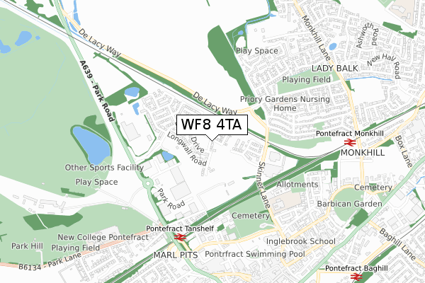
WF8 4TA maps, stats, and open data
WF8 4TA is located in the Pontefract North electoral ward, within the metropolitan district of Wakefield and the English Parliamentary constituency of Normanton, Pontefract and Castleford. The Sub Integrated Care Board (ICB) Location is NHS West Yorkshire ICB - 03R and the police force is West Yorkshire. This postcode has been in use since January 2018.
WF8 4TA maps


Licence: Open Government Licence (requires attribution)
Attribution: Contains OS data © Crown copyright and database right 2025
Source: Open Postcode Geo
Licence: Open Government Licence (requires attribution)
Attribution: Contains OS data © Crown copyright and database right 2025; Contains Royal Mail data © Royal Mail copyright and database right 2025; Source: Office for National Statistics licensed under the Open Government Licence v.3.0
WF8 4TA geodata
| Easting | 445250 |
| Northing | 422723 |
| Latitude | 53.699009 |
| Longitude | -1.316112 |
Where is WF8 4TA?
| Country | England |
| Postcode District | WF8 |
Politics
| Ward | Pontefract North |
|---|---|
| Constituency | Normanton, Pontefract And Castleford |
House Prices
Sales of detached houses in WF8 4TA
19, SEAM WAY, PONTEFRACT, WF8 4TA 2025 30 MAY £380,000 |
18, SEAM WAY, PONTEFRACT, WF8 4TA 2020 26 FEB £329,646 |
19, SEAM WAY, PONTEFRACT, WF8 4TA 2019 29 OCT £309,081 |
20, SEAM WAY, PONTEFRACT, WF8 4TA 2019 27 SEP £353,995 |
14, SEAM WAY, PONTEFRACT, WF8 4TA 2019 30 AUG £324,995 |
17, SEAM WAY, PONTEFRACT, WF8 4TA 2019 29 AUG £336,995 |
16, SEAM WAY, PONTEFRACT, WF8 4TA 2019 28 JUN £354,995 |
15, SEAM WAY, PONTEFRACT, WF8 4TA 2019 25 JUN £264,995 |
4, SEAM WAY, PONTEFRACT, WF8 4TA 2019 26 APR £250,000 |
4, SEAM WAY, PONTEFRACT, WF8 4TA 2019 26 APR £250,000 |
Licence: Contains HM Land Registry data © Crown copyright and database right 2025. This data is licensed under the Open Government Licence v3.0.
Transport
Nearest bus stops to WF8 4TA
| Skinner Lane Denwell Ter (Skinner Lane) | Monkhill | 313m |
| Skinner Lane Denwell Ter (Skinner Lane) | Monkhill | 320m |
| Skinner Ln Monkhill Drive (Skinner Lane) | Monkhill | 329m |
| Skinner Ln Monkhill Drive (Skinner Lane) | Monkhill | 334m |
| Monkhill Avene Skinner Ln (Monkhill Avenue) | Monkhill | 377m |
Nearest railway stations to WF8 4TA
| Pontefract Tanshelf Station | 0.6km |
| Pontefract Monkhill Station | 0.8km |
| Pontefract Baghill Station | 1.2km |
Broadband
Broadband access in WF8 4TA (2020 data)
| Percentage of properties with Next Generation Access | 100.0% |
| Percentage of properties with Superfast Broadband | 100.0% |
| Percentage of properties with Ultrafast Broadband | 78.3% |
| Percentage of properties with Full Fibre Broadband | 78.3% |
Superfast Broadband is between 30Mbps and 300Mbps
Ultrafast Broadband is > 300Mbps
Broadband limitations in WF8 4TA (2020 data)
| Percentage of properties unable to receive 2Mbps | 0.0% |
| Percentage of properties unable to receive 5Mbps | 0.0% |
| Percentage of properties unable to receive 10Mbps | 0.0% |
| Percentage of properties unable to receive 30Mbps | 0.0% |
Deprivation
71.4% of English postcodes are less deprived than WF8 4TA:Food Standards Agency
Three nearest food hygiene ratings to WF8 4TA (metres)


➜ Get more ratings from the Food Standards Agency
Nearest post box to WF8 4TA
| Last Collection | |||
|---|---|---|---|
| Location | Mon-Fri | Sat | Distance |
| Ladybalk Post Office | 18:00 | 12:00 | 434m |
| Cornmarket | 18:30 | 12:15 | 802m |
| Pontefract Delivery Office | 18:30 | 11:30 | 841m |
WF8 4TA ITL and WF8 4TA LAU
The below table lists the International Territorial Level (ITL) codes (formerly Nomenclature of Territorial Units for Statistics (NUTS) codes) and Local Administrative Units (LAU) codes for WF8 4TA:
| ITL 1 Code | Name |
|---|---|
| TLE | Yorkshire and The Humber |
| ITL 2 Code | Name |
| TLE4 | West Yorkshire |
| ITL 3 Code | Name |
| TLE45 | Wakefield |
| LAU 1 Code | Name |
| E08000036 | Wakefield |
WF8 4TA census areas
The below table lists the Census Output Area (OA), Lower Layer Super Output Area (LSOA), and Middle Layer Super Output Area (MSOA) for WF8 4TA:
| Code | Name | |
|---|---|---|
| OA | E00059689 | |
| LSOA | E01011841 | Wakefield 015D |
| MSOA | E02002452 | Wakefield 015 |
Nearest postcodes to WF8 4TA
| WF8 4SW | Longwall Road | 137m |
| WF8 4SQ | Ilberts Way | 361m |
| WF8 1HY | Skinner Lane | 375m |
| WF8 1JH | Lorna Cottages | 395m |
| WF8 4FU | Beechnut Lane | 425m |
| WF8 4SR | Edward Mews | 444m |
| WF8 1JQ | Ladybalk Lane | 450m |
| WF8 1HZ | Monkhill Drive | 463m |
| WF8 1JE | Monkhill Avenue | 475m |
| WF8 4FT | Hickory Court | 478m |