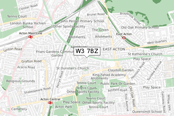
W3 7BZ maps, stats, and open data
- Home
- Postcode
- W
- W3
- W3 7
W3 7BZ is located in the East Acton electoral ward, within the London borough of Ealing and the English Parliamentary constituency of Ealing Central and Acton. The Sub Integrated Care Board (ICB) Location is NHS North West London ICB - W2U3Z and the police force is Metropolitan Police. This postcode has been in use since May 2019.
W3 7BZ maps


Source: OS Open Zoomstack (Ordnance Survey)
Licence: Open Government Licence (requires attribution)
Attribution: Contains OS data © Crown copyright and database right 2025
Source: Open Postcode GeoLicence: Open Government Licence (requires attribution)
Attribution: Contains OS data © Crown copyright and database right 2025; Contains Royal Mail data © Royal Mail copyright and database right 2025; Source: Office for National Statistics licensed under the Open Government Licence v.3.0
W3 7BZ geodata
| Easting | 521177 |
| Northing | 180921 |
| Latitude | 51.514228 |
| Longitude | -0.255070 |
Where is W3 7BZ?
| Country | England |
| Postcode District | W3 |
Politics
| Ward | East Acton |
|---|
| Constituency | Ealing Central And Acton |
|---|
Transport
Nearest bus stops to W3 7BZ
| Foster Road (Western Avenue) | East Acton | 84m |
| Carlisle Avenue (Western Avenue) | East Acton | 166m |
| Perryn Road (Western Avenue) | East Acton | 218m |
| Glendun Road (East Acton Lane) | East Acton | 223m |
| Beechwood Grove (East Acton Lane) | East Acton | 246m |
Nearest underground/metro/tram to W3 7BZ
| East Acton Underground Station | East Acton | 606m |
| North Acton Underground Station | North Acton | 1,083m |
Nearest railway stations to W3 7BZ
| Acton Central Station | 0.8km |
| Acton Main Line Station | 0.9km |
| South Acton Station | 1.9km |
Broadband
Broadband access in W3 7BZ (2020 data)
| Percentage of properties with Next Generation Access | 100.0% |
| Percentage of properties with Superfast Broadband | 100.0% |
| Percentage of properties with Ultrafast Broadband | 100.0% |
| Percentage of properties with Full Fibre Broadband | 100.0% |
Superfast Broadband is between 30Mbps and 300Mbps
Ultrafast Broadband is > 300Mbps
Broadband limitations in W3 7BZ (2020 data)
| Percentage of properties unable to receive 2Mbps | 0.0% |
| Percentage of properties unable to receive 5Mbps | 0.0% |
| Percentage of properties unable to receive 10Mbps | 0.0% |
| Percentage of properties unable to receive 30Mbps | 0.0% |
Deprivation
61.7% of English postcodes are less deprived than
W3 7BZ:
Food Standards Agency
Three nearest food hygiene ratings to W3 7BZ (metres)
Strawberry Local
21 - 23 Friars Place Lane
238m
St Dunstans With St Thomas Church & Church Hall
Ealing Acton Asylum Support
➜ Get more ratings from the Food Standards Agency
Nearest post box to W3 7BZ
| | Last Collection | |
|---|
| Location | Mon-Fri | Sat | Distance |
|---|
| Friars Place | 17:30 | 12:00 | 247m |
| East Acton Lane | 17:30 | 12:00 | 258m |
| East Lane | 17:30 | 12:00 | 259m |
W3 7BZ ITL and W3 7BZ LAU
The below table lists the International Territorial Level (ITL) codes (formerly Nomenclature of Territorial Units for Statistics (NUTS) codes) and Local Administrative Units (LAU) codes for W3 7BZ:
| ITL 1 Code | Name |
|---|
| TLI | London |
| ITL 2 Code | Name |
|---|
| TLI7 | Outer London - West and North West |
| ITL 3 Code | Name |
|---|
| TLI73 | Ealing |
| LAU 1 Code | Name |
|---|
| E09000009 | Ealing |
W3 7BZ census areas
The below table lists the Census Output Area (OA), Lower Layer Super Output Area (LSOA), and Middle Layer Super Output Area (MSOA) for W3 7BZ:
| Code | Name |
|---|
| OA | E00006215 | |
|---|
| LSOA | E01001241 | Ealing 024B |
|---|
| MSOA | E02000261 | Ealing 024 |
|---|
Nearest postcodes to W3 7BZ


