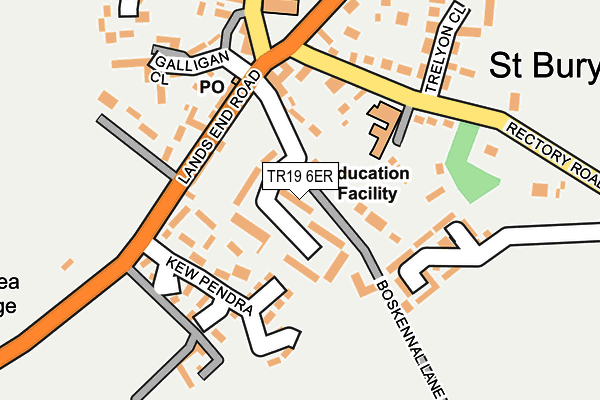
TR19 6ER is located in the Mousehole, Newlyn & St Buryan electoral ward, within the unitary authority of Cornwall and the English Parliamentary constituency of St Ives. The Sub Integrated Care Board (ICB) Location is NHS Cornwall and the Isles of Scilly ICB - 11N and the police force is Devon & Cornwall. This postcode has been in use since April 2017.


GetTheData
Source: OS OpenMap – Local (Ordnance Survey)
Source: OS VectorMap District (Ordnance Survey)
Licence: Open Government Licence (requires attribution)
| Easting | 142437 |
| Northing | 24646 |
| Latitude | 50.066016 |
| Longitude | -5.600522 |
GetTheData
Source: Open Postcode Geo
Licence: Open Government Licence
| Country | England |
| Postcode District | TR19 |
➜ See where TR19 is on a map | |
GetTheData
Source: Land Registry Price Paid Data
Licence: Open Government Licence
| Ward | Mousehole, Newlyn & St Buryan |
| Constituency | St Ives |
GetTheData
Source: ONS Postcode Database
Licence: Open Government Licence
| Merry Maidens (B3315) | Boskenna | 741m |
| Merry Maidens (B3315) | Boskenna | 741m |
| Menwinian (B3315) | Boskenna | 1,094m |
| Menwinian (B3315) | Boskenna | 1,097m |
GetTheData
Source: NaPTAN
Licence: Open Government Licence
| Percentage of properties with Next Generation Access | 0.0% |
| Percentage of properties with Superfast Broadband | 0.0% |
| Percentage of properties with Ultrafast Broadband | 0.0% |
| Percentage of properties with Full Fibre Broadband | 0.0% |
Superfast Broadband is between 30Mbps and 300Mbps
Ultrafast Broadband is > 300Mbps
| Percentage of properties unable to receive 2Mbps | 0.0% |
| Percentage of properties unable to receive 5Mbps | 0.0% |
| Percentage of properties unable to receive 10Mbps | 0.0% |
| Percentage of properties unable to receive 30Mbps | 100.0% |
GetTheData
Source: Ofcom
Licence: Ofcom Terms of Use (requires attribution)
GetTheData
Source: ONS Postcode Database
Licence: Open Government Licence


➜ Get more ratings from the Food Standards Agency
GetTheData
Source: Food Standards Agency
Licence: FSA terms & conditions
| Last Collection | |||
|---|---|---|---|
| Location | Mon-Fri | Sat | Distance |
| Boskenna Cross | 10:00 | 10:00 | 387m |
| Lamorna Gate | 10:00 | 10:00 | 1,676m |
| St Buryan Post Office | 16:10 | 09:40 | 1,841m |
GetTheData
Source: Dracos
Licence: Creative Commons Attribution-ShareAlike
The below table lists the International Territorial Level (ITL) codes (formerly Nomenclature of Territorial Units for Statistics (NUTS) codes) and Local Administrative Units (LAU) codes for TR19 6ER:
| ITL 1 Code | Name |
|---|---|
| TLK | South West (England) |
| ITL 2 Code | Name |
| TLK3 | Cornwall and Isles of Scilly |
| ITL 3 Code | Name |
| TLK30 | Cornwall and Isles of Scilly |
| LAU 1 Code | Name |
| E06000052 | Cornwall |
GetTheData
Source: ONS Postcode Directory
Licence: Open Government Licence
The below table lists the Census Output Area (OA), Lower Layer Super Output Area (LSOA), and Middle Layer Super Output Area (MSOA) for TR19 6ER:
| Code | Name | |
|---|---|---|
| OA | E00096024 | |
| LSOA | E01019006 | Cornwall 065D |
| MSOA | E02003947 | Cornwall 065 |
GetTheData
Source: ONS Postcode Directory
Licence: Open Government Licence
| TR19 6BE | Moorcroft | 162m |
| TR19 6BD | Bosliven | 831m |
| TR19 6DQ | 917m | |
| TR19 6DJ | 1049m | |
| TR19 6BS | 1070m | |
| TR19 6BQ | 1237m | |
| TR19 6BP | 1243m | |
| TR19 6DR | Boskennal | 1253m |
| TR19 6DF | 1258m | |
| TR19 6BN | 1315m |
GetTheData
Source: Open Postcode Geo; Land Registry Price Paid Data
Licence: Open Government Licence