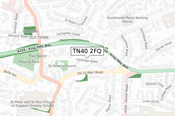
TN40 2FQ maps, stats, and open data
- Home
- Postcode
- TN
- TN40
- TN40 2
TN40 2FQ is located in the Bexhill Old Town & Worsham electoral ward, within the local authority district of Rother and the English Parliamentary constituency of Bexhill and Battle. The Sub Integrated Care Board (ICB) Location is NHS Sussex ICB - 97R and the police force is Sussex. This postcode has been in use since April 2018.
TN40 2FQ maps


Source: OS Open Zoomstack (Ordnance Survey)
Licence: Open Government Licence (requires attribution)
Attribution: Contains OS data © Crown copyright and database right 2025
Source: Open Postcode GeoLicence: Open Government Licence (requires attribution)
Attribution: Contains OS data © Crown copyright and database right 2025; Contains Royal Mail data © Royal Mail copyright and database right 2025; Source: Office for National Statistics licensed under the Open Government Licence v.3.0
TN40 2FQ geodata
| Easting | 574758 |
| Northing | 108130 |
| Latitude | 50.846293 |
| Longitude | 0.481061 |
Where is TN40 2FQ?
| Country | England |
| Postcode District | TN40 |
Politics
| Ward | Bexhill Old Town & Worsham |
|---|
| Constituency | Bexhill And Battle |
|---|
Transport
Nearest bus stops to TN40 2FQ
| Hastings Road (De La Warr Road) | Bexhill | 92m |
| Manor Barn (De La Warr Road) | Old Town | 101m |
| Manor Road (De La Warr Road) | Bexhill | 128m |
| Lychgates Close (St Peter's Crescent) | Bexhill | 189m |
| Manor Barn (De La Warr Road) | Old Town | 205m |
Nearest railway stations to TN40 2FQ
| Bexhill Station | 0.6km |
| Collington Station | 1.8km |
| Cooden Beach Station | 4.1km |
Broadband
Broadband access in TN40 2FQ (2020 data)
| Percentage of properties with Next Generation Access | 100.0% |
| Percentage of properties with Superfast Broadband | 100.0% |
| Percentage of properties with Ultrafast Broadband | 0.0% |
| Percentage of properties with Full Fibre Broadband | 0.0% |
Superfast Broadband is between 30Mbps and 300Mbps
Ultrafast Broadband is > 300Mbps
Broadband speed in TN40 2FQ (2019 data)
Download
| Median download speed | 31.7Mbps |
| Average download speed | 34.3Mbps |
| Maximum download speed | 64.99Mbps |
Upload
| Median upload speed | 5.8Mbps |
| Average upload speed | 5.9Mbps |
| Maximum upload speed | 17.22Mbps |
Broadband limitations in TN40 2FQ (2020 data)
| Percentage of properties unable to receive 2Mbps | 0.0% |
| Percentage of properties unable to receive 5Mbps | 0.0% |
| Percentage of properties unable to receive 10Mbps | 0.0% |
| Percentage of properties unable to receive 30Mbps | 0.0% |
Deprivation
60.3% of English postcodes are less deprived than
TN40 2FQ:
Food Standards Agency
Three nearest food hygiene ratings to TN40 2FQ (metres)
Peterhouse Retirement Home
Peter House Church Street
126m
The Royal British Legion Mais House
Mais House 18 Hastings Road
160m
The Old Town Tea Room
➜ Get more ratings from the Food Standards Agency
Nearest post box to TN40 2FQ
| | Last Collection | |
|---|
| Location | Mon-Fri | Sat | Distance |
|---|
| Fairmount Road | 17:15 | 12:00 | 182m |
| Old Town Post Office | 18:30 | 12:15 | 260m |
| St Peters Crescent | 16:45 | 12:45 | 376m |
TN40 2FQ ITL and TN40 2FQ LAU
The below table lists the International Territorial Level (ITL) codes (formerly Nomenclature of Territorial Units for Statistics (NUTS) codes) and Local Administrative Units (LAU) codes for TN40 2FQ:
| ITL 1 Code | Name |
|---|
| TLJ | South East (England) |
| ITL 2 Code | Name |
|---|
| TLJ2 | Surrey, East and West Sussex |
| ITL 3 Code | Name |
|---|
| TLJ22 | East Sussex CC |
| LAU 1 Code | Name |
|---|
| E07000064 | Rother |
TN40 2FQ census areas
The below table lists the Census Output Area (OA), Lower Layer Super Output Area (LSOA), and Middle Layer Super Output Area (MSOA) for TN40 2FQ:
| Code | Name |
|---|
| OA | E00107248 | |
|---|
| LSOA | E01021111 | Rother 007A |
|---|
| MSOA | E02004398 | Rother 007 |
|---|
Nearest postcodes to TN40 2FQ


