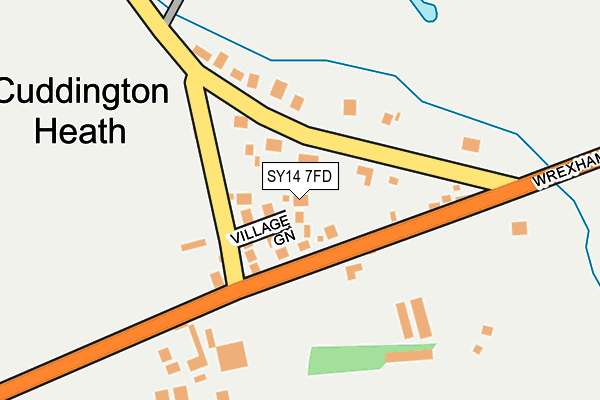
SY14 7FD is located in the Malpas electoral ward, within the unitary authority of Cheshire West and Chester and the English Parliamentary constituency of Eddisbury. The Sub Integrated Care Board (ICB) Location is NHS Cheshire and Merseyside ICB - 27D and the police force is Cheshire. This postcode has been in use since April 2017.


GetTheData
Source: OS OpenMap – Local (Ordnance Survey)
Source: OS VectorMap District (Ordnance Survey)
Licence: Open Government Licence (requires attribution)
| Easting | 347114 |
| Northing | 346773 |
| Latitude | 53.015648 |
| Longitude | -2.789762 |
GetTheData
Source: Open Postcode Geo
Licence: Open Government Licence
| Country | England |
| Postcode District | SY14 |
➜ See where SY14 is on a map ➜ Where is Cuddington Heath? | |
GetTheData
Source: Land Registry Price Paid Data
Licence: Open Government Licence
| Ward | Malpas |
| Constituency | Eddisbury |
GetTheData
Source: ONS Postcode Database
Licence: Open Government Licence
| Heath Farm (Wrexham Road) | Cuddington Heath | 138m |
| Heath Farm (Wrexham Road) | Cuddington Heath | 143m |
GetTheData
Source: NaPTAN
Licence: Open Government Licence
| Percentage of properties with Next Generation Access | 100.0% |
| Percentage of properties with Superfast Broadband | 100.0% |
| Percentage of properties with Ultrafast Broadband | 0.0% |
| Percentage of properties with Full Fibre Broadband | 0.0% |
Superfast Broadband is between 30Mbps and 300Mbps
Ultrafast Broadband is > 300Mbps
| Percentage of properties unable to receive 2Mbps | 0.0% |
| Percentage of properties unable to receive 5Mbps | 0.0% |
| Percentage of properties unable to receive 10Mbps | 0.0% |
| Percentage of properties unable to receive 30Mbps | 0.0% |
GetTheData
Source: Ofcom
Licence: Ofcom Terms of Use (requires attribution)
GetTheData
Source: ONS Postcode Database
Licence: Open Government Licence


➜ Get more ratings from the Food Standards Agency
GetTheData
Source: Food Standards Agency
Licence: FSA terms & conditions
| Last Collection | |||
|---|---|---|---|
| Location | Mon-Fri | Sat | Distance |
| Malpas Post Office | 17:30 | 11:00 | 1,692m |
| Mercer Close | 17:15 | 11:00 | 1,863m |
| Well Street | 17:15 | 10:00 | 2,035m |
GetTheData
Source: Dracos
Licence: Creative Commons Attribution-ShareAlike
The below table lists the International Territorial Level (ITL) codes (formerly Nomenclature of Territorial Units for Statistics (NUTS) codes) and Local Administrative Units (LAU) codes for SY14 7FD:
| ITL 1 Code | Name |
|---|---|
| TLD | North West (England) |
| ITL 2 Code | Name |
| TLD6 | Cheshire |
| ITL 3 Code | Name |
| TLD63 | Cheshire West and Chester |
| LAU 1 Code | Name |
| E06000050 | Cheshire West and Chester |
GetTheData
Source: ONS Postcode Directory
Licence: Open Government Licence
The below table lists the Census Output Area (OA), Lower Layer Super Output Area (LSOA), and Middle Layer Super Output Area (MSOA) for SY14 7FD:
| Code | Name | |
|---|---|---|
| OA | E00092588 | |
| LSOA | E01018357 | Cheshire West and Chester 047D |
| MSOA | E02003810 | Cheshire West and Chester 047 |
GetTheData
Source: ONS Postcode Directory
Licence: Open Government Licence
| SY14 7EN | Chorlton Lane | 66m |
| SY14 7EL | 101m | |
| SY14 7EW | Chorlton Lane | 491m |
| SY14 7AH | Oldcastle Lane | 526m |
| SY14 7AB | Oldcastle Lane | 781m |
| SY14 7AQ | Pool Lane | 814m |
| SY14 7AA | Sunnyside | 860m |
| SY14 7EJ | Wrexham Road | 978m |
| SY14 7EQ | Dimelow Court | 1105m |
| SY14 7AJ | 1145m |
GetTheData
Source: Open Postcode Geo; Land Registry Price Paid Data
Licence: Open Government Licence