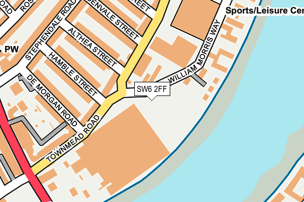
SW6 2FF is located in the Sands End electoral ward, within the London borough of Hammersmith and Fulham and the English Parliamentary constituency of Chelsea and Fulham. The Sub Integrated Care Board (ICB) Location is NHS North West London ICB - W2U3Z and the police force is Metropolitan Police. This postcode has been in use since April 2023.


GetTheData
Source: OS OpenMap – Local (Ordnance Survey)
Source: OS VectorMap District (Ordnance Survey)
Licence: Open Government Licence (requires attribution)
| Easting | 526102 |
| Northing | 175890 |
| Latitude | 51.467937 |
| Longitude | -0.185928 |
GetTheData
Source: Open Postcode Geo
Licence: Open Government Licence
| Country | England |
| Postcode District | SW6 |
➜ See where SW6 is on a map ➜ Where is London? | |
GetTheData
Source: Land Registry Price Paid Data
Licence: Open Government Licence
| Ward | Sands End |
| Constituency | Chelsea And Fulham |
GetTheData
Source: ONS Postcode Database
Licence: Open Government Licence
| Sands End Sainsbury's (William Morris Way) | Sands End | 18m |
| William Morris Waysainsbury's (Townmead Road) | Sands End | 73m |
| William Morris Waysainsbury's (Townmead Road) | Sands End | 110m |
| Wandsworth Bridge (Townmead Road) | Sands End | 147m |
| Wandsworth Bridge Townmead Rd (Townmead Road) | Sands End | 220m |
| Parsons Green Underground Station | Parsons Green | 1,336m |
| Fulham Broadway Underground Station | Fulham Broadway | 1,502m |
| Wandsworth Town Station | 0.8km |
| Imperial Wharf Station | 0.8km |
| Clapham Junction Station | 1.2km |
GetTheData
Source: NaPTAN
Licence: Open Government Licence
GetTheData
Source: ONS Postcode Database
Licence: Open Government Licence

➜ Get more ratings from the Food Standards Agency
GetTheData
Source: Food Standards Agency
Licence: FSA terms & conditions
| Last Collection | |||
|---|---|---|---|
| Location | Mon-Fri | Sat | Distance |
| Townmead Road | 17:30 | 12:00 | 88m |
| Stephendale Road | 17:30 | 12:00 | 291m |
| 200 York Road | 17:30 | 12:00 | 488m |
GetTheData
Source: Dracos
Licence: Creative Commons Attribution-ShareAlike
The below table lists the International Territorial Level (ITL) codes (formerly Nomenclature of Territorial Units for Statistics (NUTS) codes) and Local Administrative Units (LAU) codes for SW6 2FF:
| ITL 1 Code | Name |
|---|---|
| TLI | London |
| ITL 2 Code | Name |
| TLI3 | Inner London - West |
| ITL 3 Code | Name |
| TLI33 | Kensington & Chelsea and Hammersmith & Fulham |
| LAU 1 Code | Name |
| E09000013 | Hammersmith and Fulham |
GetTheData
Source: ONS Postcode Directory
Licence: Open Government Licence
The below table lists the Census Output Area (OA), Lower Layer Super Output Area (LSOA), and Middle Layer Super Output Area (MSOA) for SW6 2FF:
| Code | Name | |
|---|---|---|
| OA | E00009682 | |
| LSOA | E01032788 | Hammersmith and Fulham 023D |
| MSOA | E02000394 | Hammersmith and Fulham 023 |
GetTheData
Source: ONS Postcode Directory
Licence: Open Government Licence
| SW6 2RU | Townmead Road | 92m |
| SW6 2UP | William Morris Way | 105m |
| SW6 2GG | Central Avenue | 115m |
| SW6 2GN | Central Avenue | 115m |
| SW6 2GP | Central Avenue | 115m |
| SW6 2GQ | Central Avenue | 115m |
| SW6 2RR | Townmead Road | 127m |
| SW6 2UX | William Morris Way | 149m |
| SW6 2SG | Townmead Road | 155m |
| SW6 2RY | Althea Street | 157m |
GetTheData
Source: Open Postcode Geo; Land Registry Price Paid Data
Licence: Open Government Licence