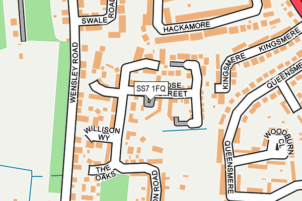
SS7 1FQ is located in the Boyce electoral ward, within the local authority district of Castle Point and the English Parliamentary constituency of Castle Point. The Sub Integrated Care Board (ICB) Location is NHS Mid and South Essex ICB - 99F and the police force is Essex. This postcode has been in use since July 2017.


GetTheData
Source: OS OpenMap – Local (Ordnance Survey)
Source: OS VectorMap District (Ordnance Survey)
Licence: Open Government Licence (requires attribution)
| Easting | 578157 |
| Northing | 188117 |
| Latitude | 51.563790 |
| Longitude | 0.568973 |
GetTheData
Source: Open Postcode Geo
Licence: Open Government Licence
| Country | England |
| Postcode District | SS7 |
➜ See where SS7 is on a map ➜ Where is Thundersley? | |
GetTheData
Source: Land Registry Price Paid Data
Licence: Open Government Licence
| Ward | Boyce |
| Constituency | Castle Point |
GetTheData
Source: ONS Postcode Database
Licence: Open Government Licence
| Glen Road (London Road) | South Benfleet | 145m |
| Glen Road (London Road) | South Benfleet | 232m |
| Kents Hill Road North (London Road) | South Benfleet | 427m |
| Kents Hill Road North (Kents Hill Road) | South Benfleet | 438m |
| Bowers Road (Kents Hill Road) | South Benfleet | 453m |
| Benfleet Station | 2.3km |
| Rayleigh Station | 3.6km |
| Pitsea Station | 4.4km |
GetTheData
Source: NaPTAN
Licence: Open Government Licence
| Percentage of properties with Next Generation Access | 100.0% |
| Percentage of properties with Superfast Broadband | 100.0% |
| Percentage of properties with Ultrafast Broadband | 0.0% |
| Percentage of properties with Full Fibre Broadband | 0.0% |
Superfast Broadband is between 30Mbps and 300Mbps
Ultrafast Broadband is > 300Mbps
| Median download speed | 39.1Mbps |
| Average download speed | 39.3Mbps |
| Maximum download speed | 74.38Mbps |
| Median upload speed | 10.0Mbps |
| Average upload speed | 9.7Mbps |
| Maximum upload speed | 19.21Mbps |
| Percentage of properties unable to receive 2Mbps | 0.0% |
| Percentage of properties unable to receive 5Mbps | 0.0% |
| Percentage of properties unable to receive 10Mbps | 0.0% |
| Percentage of properties unable to receive 30Mbps | 0.0% |
GetTheData
Source: Ofcom
Licence: Ofcom Terms of Use (requires attribution)
GetTheData
Source: ONS Postcode Database
Licence: Open Government Licence


➜ Get more ratings from the Food Standards Agency
GetTheData
Source: Food Standards Agency
Licence: FSA terms & conditions
| Last Collection | |||
|---|---|---|---|
| Location | Mon-Fri | Sat | Distance |
| Southwold Crescent | 17:00 | 12:00 | 466m |
| Raymonds Drive | 17:00 | 11:45 | 1,000m |
| Park Road | 17:15 | 12:30 | 1,108m |
GetTheData
Source: Dracos
Licence: Creative Commons Attribution-ShareAlike
The below table lists the International Territorial Level (ITL) codes (formerly Nomenclature of Territorial Units for Statistics (NUTS) codes) and Local Administrative Units (LAU) codes for SS7 1FQ:
| ITL 1 Code | Name |
|---|---|
| TLH | East |
| ITL 2 Code | Name |
| TLH3 | Essex |
| ITL 3 Code | Name |
| TLH37 | Essex Thames Gateway |
| LAU 1 Code | Name |
| E07000069 | Castle Point |
GetTheData
Source: ONS Postcode Directory
Licence: Open Government Licence
The below table lists the Census Output Area (OA), Lower Layer Super Output Area (LSOA), and Middle Layer Super Output Area (MSOA) for SS7 1FQ:
| Code | Name | |
|---|---|---|
| OA | E00109130 | |
| LSOA | E01021481 | Castle Point 004B |
| MSOA | E02004476 | Castle Point 004 |
GetTheData
Source: ONS Postcode Directory
Licence: Open Government Licence
| SS7 1AX | London Road | 71m |
| SS7 1AU | Rhoda Road | 84m |
| SS7 1AR | Catherine Road | 94m |
| SS7 1AW | London Road | 110m |
| SS7 1BN | London Road | 191m |
| SS7 1AP | London Road | 204m |
| SS7 1BQ | Downer Road | 205m |
| SS7 1JA | Bowers Road | 236m |
| SS7 1AT | Bowers Road | 255m |
| SS7 1AN | Glen Road | 275m |
GetTheData
Source: Open Postcode Geo; Land Registry Price Paid Data
Licence: Open Government Licence