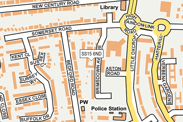
SS15 6ND is located in the Laindon Park electoral ward, within the local authority district of Basildon and the English Parliamentary constituency of Basildon and Billericay. The Sub Integrated Care Board (ICB) Location is NHS Mid and South Essex ICB - 99E and the police force is Essex. This postcode has been in use since April 2017.


GetTheData
Source: OS OpenMap – Local (Ordnance Survey)
Source: OS VectorMap District (Ordnance Survey)
Licence: Open Government Licence (requires attribution)
| Easting | 567178 |
| Northing | 189903 |
| Latitude | 51.583193 |
| Longitude | 0.411584 |
GetTheData
Source: Open Postcode Geo
Licence: Open Government Licence
| Country | England |
| Postcode District | SS15 |
➜ See where SS15 is on a map ➜ Where is Basildon? | |
GetTheData
Source: Land Registry Price Paid Data
Licence: Open Government Licence
| Ward | Laindon Park |
| Constituency | Basildon And Billericay |
GetTheData
Source: ONS Postcode Database
Licence: Open Government Licence
3, TONBRIDGE DRIVE, BASILDON, SS15 6ND 2018 23 MAR £374,995 |
GetTheData
Source: HM Land Registry Price Paid Data
Licence: Contains HM Land Registry data © Crown copyright and database right 2025. This data is licensed under the Open Government Licence v3.0.
| Home Mead (King Edward Road) | Laindon | 505m |
| Home Mead (King Edward Road) | Laindon | 538m |
| Powell Road (Devonshire Road) | Laindon | 567m |
| Powell Road (Devonshire Road) | Laindon | 615m |
| Tattenham Road (King Edward Road) | Laindon | 645m |
| Laindon Station | 2km |
| Basildon Station | 3.6km |
| West Horndon Station | 5.2km |
GetTheData
Source: NaPTAN
Licence: Open Government Licence
| Percentage of properties with Next Generation Access | 100.0% |
| Percentage of properties with Superfast Broadband | 100.0% |
| Percentage of properties with Ultrafast Broadband | 100.0% |
| Percentage of properties with Full Fibre Broadband | 100.0% |
Superfast Broadband is between 30Mbps and 300Mbps
Ultrafast Broadband is > 300Mbps
| Median download speed | 8.0Mbps |
| Average download speed | 10.3Mbps |
| Maximum download speed | 40.00Mbps |
| Median upload speed | 1.0Mbps |
| Average upload speed | 1.6Mbps |
| Maximum upload speed | 10.00Mbps |
| Percentage of properties unable to receive 2Mbps | 0.0% |
| Percentage of properties unable to receive 5Mbps | 0.0% |
| Percentage of properties unable to receive 10Mbps | 0.0% |
| Percentage of properties unable to receive 30Mbps | 0.0% |
GetTheData
Source: Ofcom
Licence: Ofcom Terms of Use (requires attribution)
GetTheData
Source: ONS Postcode Database
Licence: Open Government Licence


➜ Get more ratings from the Food Standards Agency
GetTheData
Source: Food Standards Agency
Licence: FSA terms & conditions
| Last Collection | |||
|---|---|---|---|
| Location | Mon-Fri | Sat | Distance |
| Railway Approach | 17:30 | 12:00 | 1,053m |
| Hornbeam Way | 17:45 | 12:00 | 1,679m |
| Noak Hill Road | 16:30 | 11:45 | 1,691m |
GetTheData
Source: Dracos
Licence: Creative Commons Attribution-ShareAlike
The below table lists the International Territorial Level (ITL) codes (formerly Nomenclature of Territorial Units for Statistics (NUTS) codes) and Local Administrative Units (LAU) codes for SS15 6ND:
| ITL 1 Code | Name |
|---|---|
| TLH | East |
| ITL 2 Code | Name |
| TLH3 | Essex |
| ITL 3 Code | Name |
| TLH37 | Essex Thames Gateway |
| LAU 1 Code | Name |
| E07000066 | Basildon |
GetTheData
Source: ONS Postcode Directory
Licence: Open Government Licence
The below table lists the Census Output Area (OA), Lower Layer Super Output Area (LSOA), and Middle Layer Super Output Area (MSOA) for SS15 6ND:
| Code | Name | |
|---|---|---|
| OA | E00108068 | |
| LSOA | E01021278 | Basildon 014E |
| MSOA | E02004437 | Basildon 014 |
GetTheData
Source: ONS Postcode Directory
Licence: Open Government Licence
| SS15 6LA | Stamford Drive | 96m |
| SS15 6FU | Dulwich Avenue | 179m |
| SS15 6DL | Bourne Avenue | 191m |
| SS15 6DY | Bourne Avenue | 213m |
| SS15 6LJ | Abingdon Close | 222m |
| SS15 6JQ | Warwick Crescent | 247m |
| SS15 6LW | Reeds Close | 278m |
| SS15 6DZ | Bourne Close | 284m |
| SS15 6LS | Warwick Crescent | 304m |
| SS15 6DG | Bourne Close | 325m |
GetTheData
Source: Open Postcode Geo; Land Registry Price Paid Data
Licence: Open Government Licence