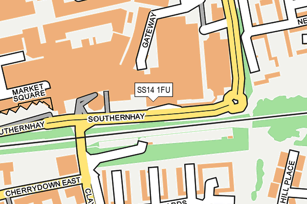
SS14 1FU is located in the St Martin's electoral ward, within the local authority district of Basildon and the English Parliamentary constituency of Basildon and Billericay. The Sub Integrated Care Board (ICB) Location is NHS Mid and South Essex ICB - 99E and the police force is Essex. This postcode has been in use since May 2017.


GetTheData
Source: OS OpenMap – Local (Ordnance Survey)
Source: OS VectorMap District (Ordnance Survey)
Licence: Open Government Licence (requires attribution)
| Easting | 570775 |
| Northing | 188430 |
| Latitude | 51.568883 |
| Longitude | 0.462734 |
GetTheData
Source: Open Postcode Geo
Licence: Open Government Licence
| Country | England |
| Postcode District | SS14 |
➜ See where SS14 is on a map ➜ Where is Basildon? | |
GetTheData
Source: Land Registry Price Paid Data
Licence: Open Government Licence
| Ward | St Martin's |
| Constituency | Basildon And Billericay |
GetTheData
Source: ONS Postcode Database
Licence: Open Government Licence
| Asda Eastgate (Southernhay) | Basildon Town Centre | 33m |
| Asda Eastgate (Southernhay) | Basildon Town Centre | 62m |
| Waldegrave (Clay Hill Road) | Basildon | 239m |
| Long Riding (Southernhay) | Basildon | 263m |
| Waldegrave (Clay Hill Road) | Basildon | 281m |
| Basildon Station | 0.4km |
| Laindon Station | 2.7km |
| Pitsea Station | 3.2km |
GetTheData
Source: NaPTAN
Licence: Open Government Licence
| Percentage of properties with Next Generation Access | 0.0% |
| Percentage of properties with Superfast Broadband | 0.0% |
| Percentage of properties with Ultrafast Broadband | 0.0% |
| Percentage of properties with Full Fibre Broadband | 0.0% |
Superfast Broadband is between 30Mbps and 300Mbps
Ultrafast Broadband is > 300Mbps
| Median download speed | 21.9Mbps |
| Average download speed | 21.0Mbps |
| Maximum download speed | 23.44Mbps |
| Median upload speed | 1.2Mbps |
| Average upload speed | 1.2Mbps |
| Maximum upload speed | 1.26Mbps |
| Percentage of properties unable to receive 2Mbps | 0.0% |
| Percentage of properties unable to receive 5Mbps | 0.0% |
| Percentage of properties unable to receive 10Mbps | 0.0% |
| Percentage of properties unable to receive 30Mbps | 100.0% |
GetTheData
Source: Ofcom
Licence: Ofcom Terms of Use (requires attribution)
GetTheData
Source: ONS Postcode Database
Licence: Open Government Licence


➜ Get more ratings from the Food Standards Agency
GetTheData
Source: Food Standards Agency
Licence: FSA terms & conditions
| Last Collection | |||
|---|---|---|---|
| Location | Mon-Fri | Sat | Distance |
| Basildon Post Office | 19:00 | 13:00 | 288m |
| Waldergrave | 17:30 | 11:30 | 385m |
| The Gore | 17:45 | 11:45 | 478m |
GetTheData
Source: Dracos
Licence: Creative Commons Attribution-ShareAlike
The below table lists the International Territorial Level (ITL) codes (formerly Nomenclature of Territorial Units for Statistics (NUTS) codes) and Local Administrative Units (LAU) codes for SS14 1FU:
| ITL 1 Code | Name |
|---|---|
| TLH | East |
| ITL 2 Code | Name |
| TLH3 | Essex |
| ITL 3 Code | Name |
| TLH37 | Essex Thames Gateway |
| LAU 1 Code | Name |
| E07000066 | Basildon |
GetTheData
Source: ONS Postcode Directory
Licence: Open Government Licence
The below table lists the Census Output Area (OA), Lower Layer Super Output Area (LSOA), and Middle Layer Super Output Area (MSOA) for SS14 1FU:
| Code | Name | |
|---|---|---|
| OA | E00108303 | |
| LSOA | E01021318 | Basildon 015C |
| MSOA | E02004438 | Basildon 015 |
GetTheData
Source: ONS Postcode Directory
Licence: Open Government Licence
| SS14 1JJ | Eastgate | 53m |
| SS14 1EY | Gateway | 122m |
| SS14 1EU | Southernhay | 129m |
| SS14 1EB | Eastgate Business Centre | 140m |
| SS16 5BQ | Witchards | 183m |
| SS14 1HE | East Walk | 188m |
| SS16 5DA | Clay Hill Road | 189m |
| SS16 5BG | Witchards | 190m |
| SS16 5BH | Witchards | 211m |
| SS16 5GJ | Cherrydown East | 238m |
GetTheData
Source: Open Postcode Geo; Land Registry Price Paid Data
Licence: Open Government Licence