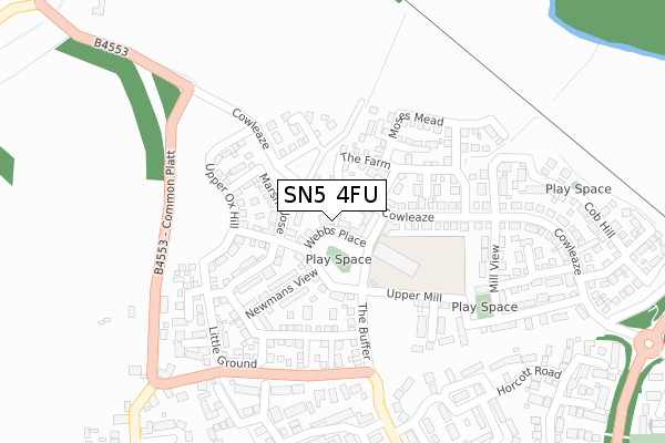
SN5 4FU maps, stats, and open data
SN5 4FU is located in the Purton electoral ward, within the unitary authority of Wiltshire and the English Parliamentary constituency of North Wiltshire. The Sub Integrated Care Board (ICB) Location is NHS Bath and North East Somerset, Swindon and Wiltshire ICB - 92 and the police force is Wiltshire. This postcode has been in use since December 2017.
SN5 4FU maps


Licence: Open Government Licence (requires attribution)
Attribution: Contains OS data © Crown copyright and database right 2025
Source: Open Postcode Geo
Licence: Open Government Licence (requires attribution)
Attribution: Contains OS data © Crown copyright and database right 2025; Contains Royal Mail data © Royal Mail copyright and database right 2025; Source: Office for National Statistics licensed under the Open Government Licence v.3.0
SN5 4FU geodata
| Easting | 411272 |
| Northing | 187040 |
| Latitude | 51.582110 |
| Longitude | -1.838706 |
Where is SN5 4FU?
| Country | England |
| Postcode District | SN5 |
Politics
| Ward | Purton |
|---|---|
| Constituency | North Wiltshire |
House Prices
Sales of detached houses in SN5 4FU
17, WEBBS PLACE, PURTON, SWINDON, SN5 4FU 2018 26 JAN £375,000 |
9, WEBBS PLACE, PURTON, SWINDON, SN5 4FU 2017 14 DEC £334,000 |
7, WEBBS PLACE, PURTON, SWINDON, SN5 4FU 2017 11 DEC £334,000 |
5, WEBBS PLACE, PURTON, SWINDON, SN5 4FU 2017 28 NOV £288,000 |
1, WEBBS PLACE, PURTON, SWINDON, SN5 4FU 2017 15 NOV £385,000 |
Licence: Contains HM Land Registry data © Crown copyright and database right 2025. This data is licensed under the Open Government Licence v3.0.
Transport
Nearest bus stops to SN5 4FU
| Webbs Wood (Swinley Drive) | Peatmoor | 344m |
| Foresters Arms (Purton Road) | Common Platt | 350m |
| Foresters Arms (Purton Road) | Common Platt | 354m |
| Webbs Wood (Swinley Drive) | Peatmoor | 370m |
| Ridgeway Farm | Sparcells | 413m |
Nearest railway stations to SN5 4FU
| Swindon Station | 4.1km |
Broadband
Broadband access in SN5 4FU (2020 data)
| Percentage of properties with Next Generation Access | 100.0% |
| Percentage of properties with Superfast Broadband | 100.0% |
| Percentage of properties with Ultrafast Broadband | 100.0% |
| Percentage of properties with Full Fibre Broadband | 100.0% |
Superfast Broadband is between 30Mbps and 300Mbps
Ultrafast Broadband is > 300Mbps
Broadband limitations in SN5 4FU (2020 data)
| Percentage of properties unable to receive 2Mbps | 0.0% |
| Percentage of properties unable to receive 5Mbps | 0.0% |
| Percentage of properties unable to receive 10Mbps | 0.0% |
| Percentage of properties unable to receive 30Mbps | 0.0% |
Deprivation
34.3% of English postcodes are less deprived than SN5 4FU:Food Standards Agency
Three nearest food hygiene ratings to SN5 4FU (metres)


➜ Get more ratings from the Food Standards Agency
Nearest post box to SN5 4FU
| Last Collection | |||
|---|---|---|---|
| Location | Mon-Fri | Sat | Distance |
| Common Platt | 16:00 | 09:15 | 467m |
| Roughmoor Village Centre | 17:30 | 12:30 | 615m |
| Swinley Drive | 17:30 | 12:30 | 628m |
SN5 4FU ITL and SN5 4FU LAU
The below table lists the International Territorial Level (ITL) codes (formerly Nomenclature of Territorial Units for Statistics (NUTS) codes) and Local Administrative Units (LAU) codes for SN5 4FU:
| ITL 1 Code | Name |
|---|---|
| TLK | South West (England) |
| ITL 2 Code | Name |
| TLK1 | Gloucestershire, Wiltshire and Bath/Bristol area |
| ITL 3 Code | Name |
| TLK15 | Wiltshire |
| LAU 1 Code | Name |
| E06000054 | Wiltshire |
SN5 4FU census areas
The below table lists the Census Output Area (OA), Lower Layer Super Output Area (LSOA), and Middle Layer Super Output Area (MSOA) for SN5 4FU:
| Code | Name | |
|---|---|---|
| OA | E00162969 | |
| LSOA | E01031954 | Wiltshire 003A |
| MSOA | E02006646 | Wiltshire 003 |
Nearest postcodes to SN5 4FU
| SN5 4FN | Mill View | 223m |
| SN5 5DF | Ash Close | 273m |
| SN5 4FL | Upper Mill | 282m |
| SN5 4FP | Lower Mill | 291m |
| SN5 5DE | Linden Way | 302m |
| SN5 4FQ | Cowleaze | 323m |
| SN5 4FR | Cob Hill | 333m |
| SN5 5BA | Letterage Road | 337m |
| SN5 5AZ | Frith Copse | 342m |
| SN5 5BW | Horcott Road | 343m |