Property/Postcode Data Search:
SK6 2TG maps, stats, and open data
SK6 2TG is located in the Bredbury & Woodley electoral ward, within the metropolitan district of Stockport and the English Parliamentary constituency of Hazel Grove. The Sub Integrated Care Board (ICB) Location is NHS Greater Manchester ICB - 01W and the police force is Greater Manchester. This postcode has been in use since November 2017.
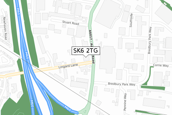
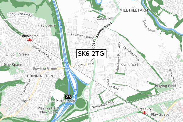
SK6 2TG maps


Source: OS Open Zoomstack (Ordnance Survey)
Licence: Open Government Licence (requires attribution)
Attribution: Contains OS data © Crown copyright and database right 2025
Source: Open Postcode Geo
Licence: Open Government Licence (requires attribution)
Attribution: Contains OS data © Crown copyright and database right 2025; Contains Royal Mail data © Royal Mail copyright and database right 2025; Source: Office for National Statistics licensed under the Open Government Licence v.3.0
Licence: Open Government Licence (requires attribution)
Attribution: Contains OS data © Crown copyright and database right 2025
Source: Open Postcode Geo
Licence: Open Government Licence (requires attribution)
Attribution: Contains OS data © Crown copyright and database right 2025; Contains Royal Mail data © Royal Mail copyright and database right 2025; Source: Office for National Statistics licensed under the Open Government Licence v.3.0
SK6 2TG geodata
| Easting | 392030 |
| Northing | 392538 |
| Latitude | 53.429584 |
| Longitude | -2.121414 |
Where is SK6 2TG?
| Country | England |
| Postcode District | SK6 |
Politics
| Ward | Bredbury & Woodley |
|---|---|
| Constituency | Hazel Grove |
Transport
Nearest bus stops to SK6 2TG
| Ashton Rd/Horsfield Arms (Ashton Rd) | Castle Hill | 33m |
| Lingard Ln/Ashton Rd (Lingard Ln) | Castle Hill | 77m |
| Lingard Ln/Ashton Rd (Lingard Lane) | Castle Hill | 87m |
| Ashton Rd/Stuart Rd (Ashton Rd) | Castle Hill | 189m |
| Lingard Lane/Essex Road (Lingard Lane) | Brinnington | 413m |
Nearest railway stations to SK6 2TG
| Brinnington Station | 1km |
| Bredbury Station | 1km |
| Woodley Station | 1.9km |
Deprivation
84.9% of English postcodes are less deprived than SK6 2TG:Food Standards Agency
Three nearest food hygiene ratings to SK6 2TG (metres)
Ashton Road Service Station

Ashton Road
67m
Subway

Ashton Road Service Station
67m
Greggs

Ashton Road Service Station
67m
➜ Get more ratings from the Food Standards Agency
Nearest post box to SK6 2TG
| Last Collection | |||
|---|---|---|---|
| Location | Mon-Fri | Sat | Distance |
| Cromwell Road | 17:30 | 11:30 | 299m |
| Brebury Park Way | 18:15 | 11:30 | 372m |
| Brinnington Tso | 17:15 | 12:00 | 812m |
SK6 2TG ITL and SK6 2TG LAU
The below table lists the International Territorial Level (ITL) codes (formerly Nomenclature of Territorial Units for Statistics (NUTS) codes) and Local Administrative Units (LAU) codes for SK6 2TG:
| ITL 1 Code | Name |
|---|---|
| TLD | North West (England) |
| ITL 2 Code | Name |
| TLD3 | Greater Manchester |
| ITL 3 Code | Name |
| TLD35 | Greater Manchester South East |
| LAU 1 Code | Name |
| E08000007 | Stockport |
SK6 2TG census areas
The below table lists the Census Output Area (OA), Lower Layer Super Output Area (LSOA), and Middle Layer Super Output Area (MSOA) for SK6 2TG:
| Code | Name | |
|---|---|---|
| OA | E00029093 | |
| LSOA | E01005744 | Stockport 009B |
| MSOA | E02001195 | Stockport 009 |
Nearest postcodes to SK6 2TG
| SK6 2QN | Ashton Road | 31m |
| SK6 2QT | Lingard Lane | 179m |
| SK6 2SR | Stuart Road | 240m |
| SK6 2SN | Bredbury Park Way | 400m |
| SK5 8HU | Rutland Crescent | 460m |
| SK5 8ED | Brinnington Road | 480m |
| SK5 8EA | Essex Road | 549m |
| SK6 2SD | Latham Close | 556m |
| SK5 8HT | Middlesex Road | 576m |
| SK5 8EF | Brinnington Road | 585m |