SK5 8LL maps, stats, and open data
SK5 8LL is located in the Brinnington & Stockport Central electoral ward, within the metropolitan district of Stockport and the English Parliamentary constituency of Stockport. The Sub Integrated Care Board (ICB) Location is NHS Greater Manchester ICB - 01W and the police force is Greater Manchester. This postcode has been in use since August 2017.
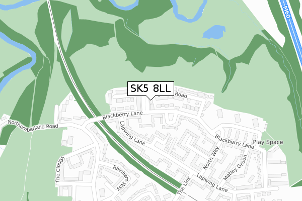
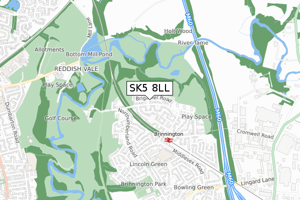
SK5 8LL maps


Licence: Open Government Licence (requires attribution)
Attribution: Contains OS data © Crown copyright and database right 2025
Source: Open Postcode Geo
Licence: Open Government Licence (requires attribution)
Attribution: Contains OS data © Crown copyright and database right 2025; Contains Royal Mail data © Royal Mail copyright and database right 2025; Source: Office for National Statistics licensed under the Open Government Licence v.3.0
SK5 8LL geodata
| Easting | 390987 |
| Northing | 393152 |
| Latitude | 53.435086 |
| Longitude | -2.137129 |
Where is SK5 8LL?
| Country | England |
| Postcode District | SK5 |
Politics
| Ward | Brinnington & Stockport Central |
|---|---|
| Constituency | Stockport |
House Prices
Sales of detached houses in SK5 8LL
9, CADET STREET, STOCKPORT, SK5 8LL 2018 21 SEP £219,995 |
1, CADET STREET, STOCKPORT, SK5 8LL 2018 10 AUG £229,995 |
12, CADET STREET, STOCKPORT, SK5 8LL 2018 16 FEB £204,950 |
11, CADET STREET, STOCKPORT, SK5 8LL 2017 27 NOV £204,950 |
2, CADET STREET, STOCKPORT, SK5 8LL 2017 25 AUG £174,950 |
4, CADET STREET, STOCKPORT, SK5 8LL 2017 25 AUG £169,950 |
10, CADET STREET, STOCKPORT, SK5 8LL 2017 25 AUG £174,950 |
7, CADET STREET, STOCKPORT, SK5 8LL 2017 18 AUG £174,950 |
Licence: Contains HM Land Registry data © Crown copyright and database right 2025. This data is licensed under the Open Government Licence v3.0.
Transport
Nearest bus stops to SK5 8LL
| Blackberry Ln/Lapwing Ln (Blackberry Ln) | Brinnington | 49m |
| Blackberry Lane | Brinnington | 111m |
| Northumberland Rd/Hollow End (Northumberl'd R) | Brinnington | 211m |
| Holtwood Walk/Blackberry Ln (Holtwood Walk) | Brinnington | 308m |
| Northumberland Rd/Dunton Green (Northumberl'd R) | Brinnington | 313m |
Nearest railway stations to SK5 8LL
| Brinnington Station | 0.4km |
| Reddish South Station | 1.4km |
| Reddish North Station | 2km |
Broadband
Broadband access in SK5 8LL (2020 data)
| Percentage of properties with Next Generation Access | 100.0% |
| Percentage of properties with Superfast Broadband | 100.0% |
| Percentage of properties with Ultrafast Broadband | 93.8% |
| Percentage of properties with Full Fibre Broadband | 0.0% |
Superfast Broadband is between 30Mbps and 300Mbps
Ultrafast Broadband is > 300Mbps
Broadband speed in SK5 8LL (2019 data)
Download
| Median download speed | 45.0Mbps |
| Average download speed | 73.2Mbps |
| Maximum download speed | 200.00Mbps |
Upload
| Median upload speed | 7.7Mbps |
| Average upload speed | 7.1Mbps |
| Maximum upload speed | 9.99Mbps |
Broadband limitations in SK5 8LL (2020 data)
| Percentage of properties unable to receive 2Mbps | 0.0% |
| Percentage of properties unable to receive 5Mbps | 0.0% |
| Percentage of properties unable to receive 10Mbps | 0.0% |
| Percentage of properties unable to receive 30Mbps | 0.0% |
Deprivation
99.3% of English postcodes are less deprived than SK5 8LL:Food Standards Agency
Three nearest food hygiene ratings to SK5 8LL (metres)


➜ Get more ratings from the Food Standards Agency
Nearest post box to SK5 8LL
| Last Collection | |||
|---|---|---|---|
| Location | Mon-Fri | Sat | Distance |
| The Link | 17:15 | 12:15 | 376m |
| Hazelbottom Road | 17:30 | 11:45 | 687m |
| Brinnington Tso | 17:15 | 12:00 | 1,015m |
SK5 8LL ITL and SK5 8LL LAU
The below table lists the International Territorial Level (ITL) codes (formerly Nomenclature of Territorial Units for Statistics (NUTS) codes) and Local Administrative Units (LAU) codes for SK5 8LL:
| ITL 1 Code | Name |
|---|---|
| TLD | North West (England) |
| ITL 2 Code | Name |
| TLD3 | Greater Manchester |
| ITL 3 Code | Name |
| TLD35 | Greater Manchester South East |
| LAU 1 Code | Name |
| E08000007 | Stockport |
SK5 8LL census areas
The below table lists the Census Output Area (OA), Lower Layer Super Output Area (LSOA), and Middle Layer Super Output Area (MSOA) for SK5 8LL:
| Code | Name | |
|---|---|---|
| OA | E00029135 | |
| LSOA | E01005756 | Stockport 004D |
| MSOA | E02001190 | Stockport 004 |
Nearest postcodes to SK5 8LL
| SK5 8JZ | Blackberry Lane | 68m |
| SK5 8JY | Lapwing Lane | 139m |
| SK5 8JU | Lapwing Lane | 181m |
| SK5 8PB | Northumberland Road | 183m |
| SK5 8LA | Blackberry Lane | 183m |
| SK5 8JS | Cawood Square | 241m |
| SK5 8PA | Hollow End | 251m |
| SK5 8HN | Rainham Way | 274m |
| SK5 8JX | Dent Close | 276m |
| SK5 8NW | Northumberland Road | 292m |