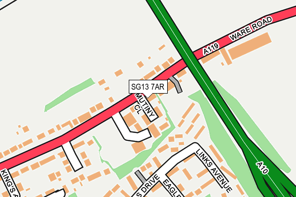
SG13 7AR is located in the Hertford Kingsmead electoral ward, within the local authority district of East Hertfordshire and the English Parliamentary constituency of Hertford and Stortford. The Sub Integrated Care Board (ICB) Location is NHS Hertfordshire and West Essex ICB - 06K and the police force is Hertfordshire. This postcode has been in use since July 2018.


GetTheData
Source: OS OpenMap – Local (Ordnance Survey)
Source: OS VectorMap District (Ordnance Survey)
Licence: Open Government Licence (requires attribution)
| Easting | 534672 |
| Northing | 213434 |
| Latitude | 51.803343 |
| Longitude | -0.048188 |
GetTheData
Source: Open Postcode Geo
Licence: Open Government Licence
| Country | England |
| Postcode District | SG13 |
➜ See where SG13 is on a map ➜ Where is Hertford? | |
GetTheData
Source: Land Registry Price Paid Data
Licence: Open Government Licence
| Ward | Hertford Kingsmead |
| Constituency | Hertford And Stortford |
GetTheData
Source: ONS Postcode Database
Licence: Open Government Licence
| Viaduct (Ware Road) | Chadwell | 37m |
| Viaduct (Ware Road) | Chadwell | 124m |
| Divot Place (Pinehurst Estate) | Pinehurst | 246m |
| Kings Road (Ware Road) | Hertford | 309m |
| Springs (Ware Road) | Chadwell | 311m |
| Ware Station | 1.4km |
| Hertford East Station | 1.8km |
| Hertford North Station | 3km |
GetTheData
Source: NaPTAN
Licence: Open Government Licence
| Percentage of properties with Next Generation Access | 100.0% |
| Percentage of properties with Superfast Broadband | 100.0% |
| Percentage of properties with Ultrafast Broadband | 0.0% |
| Percentage of properties with Full Fibre Broadband | 0.0% |
Superfast Broadband is between 30Mbps and 300Mbps
Ultrafast Broadband is > 300Mbps
| Median download speed | 40.0Mbps |
| Average download speed | 31.7Mbps |
| Maximum download speed | 46.81Mbps |
| Median upload speed | 10.0Mbps |
| Average upload speed | 8.4Mbps |
| Maximum upload speed | 16.72Mbps |
| Percentage of properties unable to receive 2Mbps | 0.0% |
| Percentage of properties unable to receive 5Mbps | 0.0% |
| Percentage of properties unable to receive 10Mbps | 0.0% |
| Percentage of properties unable to receive 30Mbps | 0.0% |
GetTheData
Source: Ofcom
Licence: Ofcom Terms of Use (requires attribution)
GetTheData
Source: ONS Postcode Database
Licence: Open Government Licence


➜ Get more ratings from the Food Standards Agency
GetTheData
Source: Food Standards Agency
Licence: FSA terms & conditions
| Last Collection | |||
|---|---|---|---|
| Location | Mon-Fri | Sat | Distance |
| Kings Road | 17:15 | 12:00 | 330m |
| Pinehurst | 17:15 | 12:00 | 398m |
| Penfield | 16:30 | 10:45 | 576m |
GetTheData
Source: Dracos
Licence: Creative Commons Attribution-ShareAlike
The below table lists the International Territorial Level (ITL) codes (formerly Nomenclature of Territorial Units for Statistics (NUTS) codes) and Local Administrative Units (LAU) codes for SG13 7AR:
| ITL 1 Code | Name |
|---|---|
| TLH | East |
| ITL 2 Code | Name |
| TLH2 | Bedfordshire and Hertfordshire |
| ITL 3 Code | Name |
| TLH23 | Hertfordshire CC |
| LAU 1 Code | Name |
| E07000242 | East Hertfordshire |
GetTheData
Source: ONS Postcode Directory
Licence: Open Government Licence
The below table lists the Census Output Area (OA), Lower Layer Super Output Area (LSOA), and Middle Layer Super Output Area (MSOA) for SG13 7AR:
| Code | Name | |
|---|---|---|
| OA | E00119277 | |
| LSOA | E01023484 | East Hertfordshire 016C |
| MSOA | E02004893 | East Hertfordshire 016 |
GetTheData
Source: ONS Postcode Directory
Licence: Open Government Licence
| SG13 7FJ | Nags Head Close | 23m |
| SG13 7EN | Ware Road | 52m |
| SG13 7SJ | Hamels Drive | 100m |
| SG13 7ER | Ware Road | 117m |
| SG13 7EW | Ware Road | 148m |
| SG13 7SW | Hamels Drive | 185m |
| SG13 7SR | Links Avenue | 186m |
| SG13 7EU | Cockbush Avenue | 216m |
| SG13 7SP | Divot Place | 236m |
| SG13 7SS | Eagle Court | 240m |
GetTheData
Source: Open Postcode Geo; Land Registry Price Paid Data
Licence: Open Government Licence