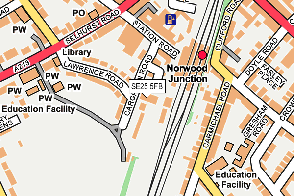
SE25 5FB is located in the South Norwood electoral ward, within the London borough of Croydon and the English Parliamentary constituency of Croydon North. The Sub Integrated Care Board (ICB) Location is NHS South West London ICB - 36L and the police force is Metropolitan Police. This postcode has been in use since March 2017.


GetTheData
Source: OS OpenMap – Local (Ordnance Survey)
Source: OS VectorMap District (Ordnance Survey)
Licence: Open Government Licence (requires attribution)
| Easting | 533939 |
| Northing | 168150 |
| Latitude | 51.396582 |
| Longitude | -0.076091 |
GetTheData
Source: Open Postcode Geo
Licence: Open Government Licence
| Country | England |
| Postcode District | SE25 |
➜ See where SE25 is on a map ➜ Where is London? | |
GetTheData
Source: Land Registry Price Paid Data
Licence: Open Government Licence
| Ward | South Norwood |
| Constituency | Croydon North |
GetTheData
Source: ONS Postcode Database
Licence: Open Government Licence
| Norwood Junction Station (Clifford Road) | South Norwood | 161m |
| South Norwood Clock Tower | South Norwood | 182m |
| Norwood Junction Station (Clifford Road) | South Norwood | 185m |
| South Norwood Clock Tower (Selhurst Road) | South Norwood | 187m |
| Norwood Junction Station (Grosvenor Road) | South Norwood | 239m |
| Harrington Road Tram Stop (Off Harrington Road) | South Norwood | 1,129m |
| Woodside Tram Stop (Spring Lane) | Woodside | 1,294m |
| Arena Tram Stop (Off Albert Road) | Woodside | 1,359m |
| Blackhorse Lane Tram Stop (Dalmally Road) | Woodside | 1,371m |
| Birkbeck Tram Stop (Elmers End Road) | Anerley | 1,625m |
| Norwood Junction Station | 0.1km |
| Selhurst Station | 1km |
| Birkbeck Station | 1.6km |
GetTheData
Source: NaPTAN
Licence: Open Government Licence
| Percentage of properties with Next Generation Access | 0.0% |
| Percentage of properties with Superfast Broadband | 0.0% |
| Percentage of properties with Ultrafast Broadband | 0.0% |
| Percentage of properties with Full Fibre Broadband | 0.0% |
Superfast Broadband is between 30Mbps and 300Mbps
Ultrafast Broadband is > 300Mbps
| Median download speed | 6.7Mbps |
| Average download speed | 7.2Mbps |
| Maximum download speed | 13.59Mbps |
| Median upload speed | 0.8Mbps |
| Average upload speed | 0.9Mbps |
| Maximum upload speed | 1.11Mbps |
| Percentage of properties unable to receive 2Mbps | 0.0% |
| Percentage of properties unable to receive 5Mbps | 0.0% |
| Percentage of properties unable to receive 10Mbps | 0.0% |
| Percentage of properties unable to receive 30Mbps | 100.0% |
GetTheData
Source: Ofcom
Licence: Ofcom Terms of Use (requires attribution)
GetTheData
Source: ONS Postcode Database
Licence: Open Government Licence


➜ Get more ratings from the Food Standards Agency
GetTheData
Source: Food Standards Agency
Licence: FSA terms & conditions
| Last Collection | |||
|---|---|---|---|
| Location | Mon-Fri | Sat | Distance |
| Norwood Junction | 17:30 | 12:00 | 114m |
| Selhurst Road | 17:30 | 12:00 | 192m |
| Birchanger Road | 17:30 | 12:00 | 194m |
GetTheData
Source: Dracos
Licence: Creative Commons Attribution-ShareAlike
The below table lists the International Territorial Level (ITL) codes (formerly Nomenclature of Territorial Units for Statistics (NUTS) codes) and Local Administrative Units (LAU) codes for SE25 5FB:
| ITL 1 Code | Name |
|---|---|
| TLI | London |
| ITL 2 Code | Name |
| TLI6 | Outer London - South |
| ITL 3 Code | Name |
| TLI62 | Croydon |
| LAU 1 Code | Name |
| E09000008 | Croydon |
GetTheData
Source: ONS Postcode Directory
Licence: Open Government Licence
The below table lists the Census Output Area (OA), Lower Layer Super Output Area (LSOA), and Middle Layer Super Output Area (MSOA) for SE25 5FB:
| Code | Name | |
|---|---|---|
| OA | E00005680 | |
| LSOA | E01001136 | Croydon 007A |
| MSOA | E02000200 | Croydon 007 |
GetTheData
Source: ONS Postcode Directory
Licence: Open Government Licence
| SE25 5AD | Cargreen Road | 18m |
| SE25 5AB | Cargreen Road | 58m |
| SE25 5AF | Cargreen Road | 84m |
| SE25 5AG | Station Road | 94m |
| SE25 5AA | Lawrence Road | 102m |
| SE25 5LT | Carmichael Road | 129m |
| SE25 5AJ | Station Road | 138m |
| SE25 5AH | Station Road | 138m |
| SE25 5LS | Carmichael Road | 165m |
| SE25 6XU | Selhurst Road | 168m |
GetTheData
Source: Open Postcode Geo; Land Registry Price Paid Data
Licence: Open Government Licence