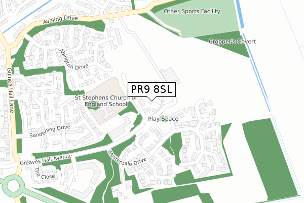
PR9 8SL maps, stats, and open data
PR9 8SL is located in the North Meols & Hesketh Bank electoral ward, within the local authority district of West Lancashire and the English Parliamentary constituency of South Ribble. The Sub Integrated Care Board (ICB) Location is NHS Lancashire and South Cumbria ICB - 02G and the police force is Lancashire. This postcode has been in use since April 2020.
PR9 8SL maps


Licence: Open Government Licence (requires attribution)
Attribution: Contains OS data © Crown copyright and database right 2025
Source: Open Postcode Geo
Licence: Open Government Licence (requires attribution)
Attribution: Contains OS data © Crown copyright and database right 2025; Contains Royal Mail data © Royal Mail copyright and database right 2025; Source: Office for National Statistics licensed under the Open Government Licence v.3.0
PR9 8SL geodata
| Easting | 339638 |
| Northing | 420316 |
| Latitude | 53.675824 |
| Longitude | -2.915235 |
Where is PR9 8SL?
| Country | England |
| Postcode District | PR9 |
Politics
| Ward | North Meols & Hesketh Bank |
|---|---|
| Constituency | South Ribble |
House Prices
Sales of detached houses in PR9 8SL
2024 27 SEP £380,000 |
2020 11 SEP £289,995 |
2, CHAMBERLAIN CLOSE, BANKS, SOUTHPORT, PR9 8SL 2020 22 APR £247,000 |
8, CHAMBERLAIN CLOSE, BANKS, SOUTHPORT, PR9 8SL 2020 20 MAR £312,000 |
Licence: Contains HM Land Registry data © Crown copyright and database right 2025. This data is licensed under the Open Government Licence v3.0.
Transport
Nearest bus stops to PR9 8SL
| Guinea Hall Avenue (Guinea Hall Lane) | Banks | 470m |
| Guinea Hall Mews (Guinea Hall Lane) | Banks | 482m |
| Guinea Hall Avenue (Guinea Hall Lane) | Banks | 484m |
| Guinea Hall Mews (Guinea Hall Lane) | Banks | 490m |
| Schwartzman Drive (Hoole Lane) | Banks | 643m |
Nearest railway stations to PR9 8SL
| Meols Cop Station | 5.2km |
Deprivation
32.4% of English postcodes are less deprived than PR9 8SL:Food Standards Agency
Three nearest food hygiene ratings to PR9 8SL (metres)


➜ Get more ratings from the Food Standards Agency
Nearest post box to PR9 8SL
| Last Collection | |||
|---|---|---|---|
| Location | Mon-Fri | Sat | Distance |
| The Ferry | 17:00 | 11:00 | 1,817m |
| Nelric Camp | 16:30 | 11:00 | 2,062m |
| Banks Road | 16:15 | 11:00 | 2,062m |
PR9 8SL ITL and PR9 8SL LAU
The below table lists the International Territorial Level (ITL) codes (formerly Nomenclature of Territorial Units for Statistics (NUTS) codes) and Local Administrative Units (LAU) codes for PR9 8SL:
| ITL 1 Code | Name |
|---|---|
| TLD | North West (England) |
| ITL 2 Code | Name |
| TLD4 | Lancashire |
| ITL 3 Code | Name |
| TLD47 | Chorley and West Lancashire |
| LAU 1 Code | Name |
| E07000127 | West Lancashire |
PR9 8SL census areas
The below table lists the Census Output Area (OA), Lower Layer Super Output Area (LSOA), and Middle Layer Super Output Area (MSOA) for PR9 8SL:
| Code | Name | |
|---|---|---|
| OA | E00129443 | |
| LSOA | E01025507 | West Lancashire 002A |
| MSOA | E02005305 | West Lancashire 002 |
Nearest postcodes to PR9 8SL
| PR9 8BL | Greaves Hall Avenue | 48m |
| PR9 8FH | Brightstone Close | 170m |
| PR9 8FU | Lonmore Close | 180m |
| PR9 8DG | Westerdale Drive | 198m |
| PR9 8GX | Abington Drive | 206m |
| PR9 8GZ | Abington Drive | 210m |
| PR9 8FT | Woodvale Court | 225m |
| PR9 8GY | Abington Drive | 251m |
| PR9 8FF | Maesbrook Close | 260m |
| PR9 8FG | Avenham Close | 273m |