Property/Postcode Data Search:
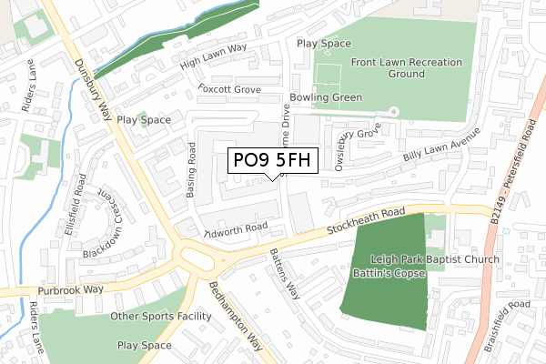
PO9 5FH maps, stats, and open data
PO9 5FH is located in the St Faith's electoral ward, within the local authority district of Havant and the English Parliamentary constituency of Havant. The Sub Integrated Care Board (ICB) Location is NHS Hampshire and Isle of Wight ICB - D9Y0V and the police force is Hampshire. This postcode has been in use since April 2020.
PO9 5FH maps


Source: OS Open Zoomstack (Ordnance Survey)
Licence: Open Government Licence (requires attribution)
Attribution: Contains OS data © Crown copyright and database right 2025
Source: Open Postcode Geo
Licence: Open Government Licence (requires attribution)
Attribution: Contains OS data © Crown copyright and database right 2025; Contains Royal Mail data © Royal Mail copyright and database right 2025; Source: Office for National Statistics licensed under the Open Government Licence v.3.0
Licence: Open Government Licence (requires attribution)
Attribution: Contains OS data © Crown copyright and database right 2025
Source: Open Postcode Geo
Licence: Open Government Licence (requires attribution)
Attribution: Contains OS data © Crown copyright and database right 2025; Contains Royal Mail data © Royal Mail copyright and database right 2025; Source: Office for National Statistics licensed under the Open Government Licence v.3.0
PO9 5FH geodata
| Easting | 473195 |
| Northing | 107817 |
| Latitude | 50.865226 |
| Longitude | -0.961267 |
Where is PO9 5FH?
| Country | England |
| Postcode District | PO9 |
Politics
| Ward | St Faith's |
|---|---|
| Constituency | Havant |
House Prices
Sales of detached houses in PO9 5FH
3, NORMANDY WAY, HAVANT, PO9 5FH 2022 31 MAR £363,051 |
1, NORMANDY WAY, HAVANT, PO9 5FH 2022 31 MAR £405,608 |
6, NORMANDY WAY, HAVANT, PO9 5FH 2022 25 FEB £456,614 |
27, NORMANDY WAY, HAVANT, PO9 5FH 2022 25 FEB £458,380 |
33, NORMANDY WAY, HAVANT, PO9 5FH 2021 29 OCT £430,995 |
8, NORMANDY WAY, HAVANT, PO9 5FH 2021 3 JUN £424,995 |
17, NORMANDY WAY, HAVANT, PO9 5FH 2021 21 MAY £434,995 |
20, NORMANDY WAY, HAVANT, PO9 5FH 2020 10 DEC £430,000 |
14, NORMANDY WAY, HAVANT, PO9 5FH 2020 27 NOV £335,995 |
16, NORMANDY WAY, HAVANT, PO9 5FH 2020 20 NOV £327,500 |
Source: HM Land Registry Price Paid Data
Licence: Contains HM Land Registry data © Crown copyright and database right 2025. This data is licensed under the Open Government Licence v3.0.
Licence: Contains HM Land Registry data © Crown copyright and database right 2025. This data is licensed under the Open Government Licence v3.0.
Transport
Nearest bus stops to PO9 5FH
| Exton Road (Wakefords Way) | West Leigh | 430m |
| Exton Road (Wakefords Way) | West Leigh | 437m |
| Locks Farm | Southleigh | 469m |
| Locks Farm (Southleigh Road) | Southleigh | 483m |
| Froxfield Road (Wakefords Way) | West Leigh | 527m |
Nearest railway stations to PO9 5FH
| Warblington Station | 1.4km |
| Havant Station | 1.9km |
| Emsworth Station | 2.2km |
Deprivation
26.4% of English postcodes are less deprived than PO9 5FH:Food Standards Agency
Three nearest food hygiene ratings to PO9 5FH (metres)
Edinburgh Woollen Mill
Garden Centre
148m
Dobbies

Garden Centre
148m
Welcome Denvilles

40 Snowberry Crescent
478m
➜ Get more ratings from the Food Standards Agency
Nearest post box to PO9 5FH
| Last Collection | |||
|---|---|---|---|
| Location | Mon-Fri | Sat | Distance |
| Eastleigh Road | 16:15 | 11:30 | 445m |
| Ashe Road | 17:30 | 11:30 | 568m |
| New Lane | 18:40 | 746m | |
PO9 5FH ITL and PO9 5FH LAU
The below table lists the International Territorial Level (ITL) codes (formerly Nomenclature of Territorial Units for Statistics (NUTS) codes) and Local Administrative Units (LAU) codes for PO9 5FH:
| ITL 1 Code | Name |
|---|---|
| TLJ | South East (England) |
| ITL 2 Code | Name |
| TLJ3 | Hampshire and Isle of Wight |
| ITL 3 Code | Name |
| TLJ35 | South Hampshire |
| LAU 1 Code | Name |
| E07000090 | Havant |
PO9 5FH census areas
The below table lists the Census Output Area (OA), Lower Layer Super Output Area (LSOA), and Middle Layer Super Output Area (MSOA) for PO9 5FH:
| Code | Name | |
|---|---|---|
| OA | E00116641 | |
| LSOA | E01022958 | Havant 014F |
| MSOA | E02004775 | Havant 014 |
Nearest postcodes to PO9 5FH
| PO9 5NA | Bartons Road | 109m |
| PO9 2FN | Japonica Way | 200m |
| PO9 2FL | Azalea Close | 225m |
| PO9 2FW | Forsythia Close | 257m |
| PO9 2FR | Fushia Close | 267m |
| PO9 2FP | Japonica Way | 275m |
| PO9 2FJ | Wisteria Gardens | 289m |
| PO9 2FD | Lilac Close | 348m |
| PO9 2NJ | Downley Road | 360m |
| PO9 2FH | Acer Way | 377m |