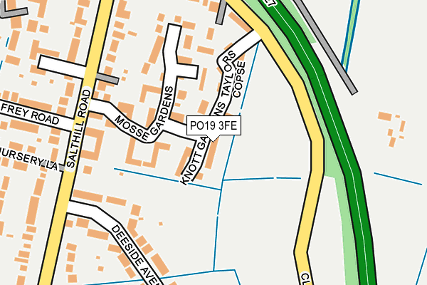
PO19 3FE is located in the Harbour Villages electoral ward, within the local authority district of Chichester and the English Parliamentary constituency of Chichester. The Sub Integrated Care Board (ICB) Location is NHS Sussex ICB - 70F and the police force is Sussex. This postcode has been in use since March 2017.


GetTheData
Source: OS OpenMap – Local (Ordnance Survey)
Source: OS VectorMap District (Ordnance Survey)
Licence: Open Government Licence (requires attribution)
| Easting | 483842 |
| Northing | 105347 |
| Latitude | 50.841575 |
| Longitude | -0.810570 |
GetTheData
Source: Open Postcode Geo
Licence: Open Government Licence
| Country | England |
| Postcode District | PO19 |
➜ See where PO19 is on a map ➜ Where is Fishbourne? | |
GetTheData
Source: Land Registry Price Paid Data
Licence: Open Government Licence
| Ward | Harbour Villages |
| Constituency | Chichester |
GetTheData
Source: ONS Postcode Database
Licence: Open Government Licence
22, KNOTT GARDENS, CHICHESTER, PO19 3FE 2025 4 APR £480,000 |
2024 3 JAN £515,000 |
2022 20 JUL £490,000 |
2020 21 FEB £273,000 |
22, KNOTT GARDENS, CHICHESTER, PO19 3FE 2017 6 OCT £460,000 |
19, KNOTT GARDENS, CHICHESTER, PO19 3FE 2017 3 AUG £535,000 |
18, KNOTT GARDENS, CHICHESTER, PO19 3FE 2017 21 JUL £415,000 |
17, KNOTT GARDENS, CHICHESTER, PO19 3FE 2017 14 JUL £415,000 |
2017 29 JUN £415,000 |
7, KNOTT GARDENS, CHICHESTER, PO19 3FE 2017 26 MAY £410,000 |
GetTheData
Source: HM Land Registry Price Paid Data
Licence: Contains HM Land Registry data © Crown copyright and database right 2025. This data is licensed under the Open Government Licence v3.0.
| Deeside Avenue (Salthill Road) | Fishbourne | 212m |
| Deeside Avenue (Salthill Road) | Fishbourne | 226m |
| Clay Lane (Salthill Road) | Fishbourne | 264m |
| Clay Lane (Salthill Road) | Fishbourne | 292m |
| Frederick Road (Clay Lane) | Fishbourne | 551m |
| Fishbourne Station | 0.4km |
| Chichester Station | 2.3km |
| Bosham Station | 2.6km |
GetTheData
Source: NaPTAN
Licence: Open Government Licence
| Percentage of properties with Next Generation Access | 100.0% |
| Percentage of properties with Superfast Broadband | 100.0% |
| Percentage of properties with Ultrafast Broadband | 4.2% |
| Percentage of properties with Full Fibre Broadband | 0.0% |
Superfast Broadband is between 30Mbps and 300Mbps
Ultrafast Broadband is > 300Mbps
| Median download speed | 57.9Mbps |
| Average download speed | 50.6Mbps |
| Maximum download speed | 80.00Mbps |
| Median upload speed | 18.3Mbps |
| Average upload speed | 13.9Mbps |
| Maximum upload speed | 20.00Mbps |
| Percentage of properties unable to receive 2Mbps | 0.0% |
| Percentage of properties unable to receive 5Mbps | 0.0% |
| Percentage of properties unable to receive 10Mbps | 0.0% |
| Percentage of properties unable to receive 30Mbps | 0.0% |
GetTheData
Source: Ofcom
Licence: Ofcom Terms of Use (requires attribution)
GetTheData
Source: ONS Postcode Database
Licence: Open Government Licence


➜ Get more ratings from the Food Standards Agency
GetTheData
Source: Food Standards Agency
Licence: FSA terms & conditions
| Last Collection | |||
|---|---|---|---|
| Location | Mon-Fri | Sat | Distance |
| The Woolpack Inn | 18:15 | 12:30 | 688m |
| Tesco Store | 16:00 | 11:30 | 1,058m |
| Neville Road | 16:15 | 12:15 | 1,251m |
GetTheData
Source: Dracos
Licence: Creative Commons Attribution-ShareAlike
The below table lists the International Territorial Level (ITL) codes (formerly Nomenclature of Territorial Units for Statistics (NUTS) codes) and Local Administrative Units (LAU) codes for PO19 3FE:
| ITL 1 Code | Name |
|---|---|
| TLJ | South East (England) |
| ITL 2 Code | Name |
| TLJ2 | Surrey, East and West Sussex |
| ITL 3 Code | Name |
| TLJ27 | West Sussex (South West) |
| LAU 1 Code | Name |
| E07000225 | Chichester |
GetTheData
Source: ONS Postcode Directory
Licence: Open Government Licence
The below table lists the Census Output Area (OA), Lower Layer Super Output Area (LSOA), and Middle Layer Super Output Area (MSOA) for PO19 3FE:
| Code | Name | |
|---|---|---|
| OA | E00160670 | |
| LSOA | E01031505 | Chichester 011D |
| MSOA | E02006571 | Chichester 011 |
GetTheData
Source: ONS Postcode Directory
Licence: Open Government Licence
| PO19 3PQ | Mosse Gardens | 99m |
| PO19 3RL | Senator Gardens | 102m |
| PO19 3FD | Taylors Copse | 107m |
| PO19 3SD | Margary Close | 149m |
| PO19 3RP | Follis Gardens | 159m |
| PO19 3PG | Mosse Gardens | 161m |
| PO19 3QF | Deeside Avenue | 186m |
| PO19 3PX | Clay Lane | 197m |
| PO19 3PZ | Salthill Road | 198m |
| PO19 3QG | Deeside Avenue | 207m |
GetTheData
Source: Open Postcode Geo; Land Registry Price Paid Data
Licence: Open Government Licence