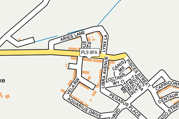
PL9 8FA is located in the Wembury & Brixton electoral ward, within the local authority district of South Hams and the English Parliamentary constituency of South West Devon. The Sub Integrated Care Board (ICB) Location is NHS Devon ICB - 15N and the police force is Devon & Cornwall. This postcode has been in use since July 2017.


GetTheData
Source: OS OpenMap – Local (Ordnance Survey)
Source: OS VectorMap District (Ordnance Survey)
Licence: Open Government Licence (requires attribution)
| Easting | 254136 |
| Northing | 53787 |
| Latitude | 50.365845 |
| Longitude | -4.052307 |
GetTheData
Source: Open Postcode Geo
Licence: Open Government Licence
| Country | England |
| Postcode District | PL9 |
➜ See where PL9 is on a map ➜ Where is Sherford? | |
GetTheData
Source: Land Registry Price Paid Data
Licence: Open Government Licence
| Ward | Wembury & Brixton |
| Constituency | South West Devon |
GetTheData
Source: ONS Postcode Database
Licence: Open Government Licence
| Candish Drive East (Candish Drive) | Elburton | 411m |
| Candish Drive | Elburton | 464m |
| Brookwood Road (Sherford Road) | Elburton | 553m |
| Candish Drive West (Candish Drive) | Elburton | 554m |
| Brookwood Road (Sherford Road) | Elburton | 564m |
GetTheData
Source: NaPTAN
Licence: Open Government Licence
| Percentage of properties with Next Generation Access | 100.0% |
| Percentage of properties with Superfast Broadband | 100.0% |
| Percentage of properties with Ultrafast Broadband | 100.0% |
| Percentage of properties with Full Fibre Broadband | 100.0% |
Superfast Broadband is between 30Mbps and 300Mbps
Ultrafast Broadband is > 300Mbps
| Median download speed | 53.3Mbps |
| Average download speed | 86.2Mbps |
| Maximum download speed | 200.00Mbps |
| Median upload speed | 0.8Mbps |
| Average upload speed | 0.8Mbps |
| Maximum upload speed | 1.05Mbps |
| Percentage of properties unable to receive 2Mbps | 0.0% |
| Percentage of properties unable to receive 5Mbps | 0.0% |
| Percentage of properties unable to receive 10Mbps | 0.0% |
| Percentage of properties unable to receive 30Mbps | 0.0% |
GetTheData
Source: Ofcom
Licence: Ofcom Terms of Use (requires attribution)
GetTheData
Source: ONS Postcode Database
Licence: Open Government Licence


➜ Get more ratings from the Food Standards Agency
GetTheData
Source: Food Standards Agency
Licence: FSA terms & conditions
| Last Collection | |||
|---|---|---|---|
| Location | Mon-Fri | Sat | Distance |
| Elburton Post Office | 17:00 | 12:00 | 1,214m |
| Reservoir Road | 17:00 | 12:45 | 1,317m |
| Charnhill Way | 16:45 | 12:30 | 1,869m |
GetTheData
Source: Dracos
Licence: Creative Commons Attribution-ShareAlike
The below table lists the International Territorial Level (ITL) codes (formerly Nomenclature of Territorial Units for Statistics (NUTS) codes) and Local Administrative Units (LAU) codes for PL9 8FA:
| ITL 1 Code | Name |
|---|---|
| TLK | South West (England) |
| ITL 2 Code | Name |
| TLK4 | Devon |
| ITL 3 Code | Name |
| TLK43 | Devon CC |
| LAU 1 Code | Name |
| E07000044 | South Hams |
GetTheData
Source: ONS Postcode Directory
Licence: Open Government Licence
The below table lists the Census Output Area (OA), Lower Layer Super Output Area (LSOA), and Middle Layer Super Output Area (MSOA) for PL9 8FA:
| Code | Name | |
|---|---|---|
| OA | E00165894 | |
| LSOA | E01020187 | South Hams 009D |
| MSOA | E02004197 | South Hams 009 |
GetTheData
Source: ONS Postcode Directory
Licence: Open Government Licence
| PL9 8BG | Sherford Road | 431m |
| PL9 8DB | Candish Drive | 450m |
| PL9 8BJ | Sherford Road | 471m |
| PL9 8BQ | Yarrowmead | 496m |
| PL9 8BB | Sherford Walk | 512m |
| PL9 8BW | Sherford Road | 521m |
| PL9 8BL | Hazelwood Crescent | 523m |
| PL9 8DD | Vinery Lane | 593m |
| PL9 8DE | Vinery Lane | 613m |
| PL9 8LX | Pepper Lane | 613m |
GetTheData
Source: Open Postcode Geo; Land Registry Price Paid Data
Licence: Open Government Licence