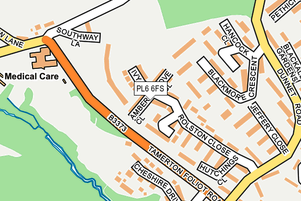
PL6 6FS is located in the Southway electoral ward, within the unitary authority of Plymouth and the English Parliamentary constituency of Plymouth, Moor View. The Sub Integrated Care Board (ICB) Location is NHS Devon ICB - 15N and the police force is Devon & Cornwall. This postcode has been in use since March 2017.


GetTheData
Source: OS OpenMap – Local (Ordnance Survey)
Source: OS VectorMap District (Ordnance Survey)
Licence: Open Government Licence (requires attribution)
| Easting | 247476 |
| Northing | 60749 |
| Latitude | 50.426724 |
| Longitude | -4.148711 |
GetTheData
Source: Open Postcode Geo
Licence: Open Government Licence
| Country | England |
| Postcode District | PL6 |
➜ See where PL6 is on a map ➜ Where is Plymouth? | |
GetTheData
Source: Land Registry Price Paid Data
Licence: Open Government Licence
| Ward | Southway |
| Constituency | Plymouth, Moor View |
GetTheData
Source: ONS Postcode Database
Licence: Open Government Licence
55, IVY DRIVE, PLYMOUTH, PL6 6FS 2018 29 JUN £299,950 |
GetTheData
Source: HM Land Registry Price Paid Data
Licence: Contains HM Land Registry data © Crown copyright and database right 2025. This data is licensed under the Open Government Licence v3.0.
| Cann Lodge | Tamerton Foliot | 97m |
| Cann House (Tamerton Foliot Road) | Tamerton Foliot | 165m |
| Cheshire Drive | Tamerton Foliot | 202m |
| Cheshire Drive | Tamerton Foliot | 206m |
| Church Row Lane (Tamerton Foliot Road) | Tamerton Foliot | 239m |
| Bere Ferrers Station | 3.6km |
| St Budeaux Victoria Road Station | 3.9km |
| St Budeaux Ferry Road Station | 3.9km |
GetTheData
Source: NaPTAN
Licence: Open Government Licence
| Percentage of properties with Next Generation Access | 100.0% |
| Percentage of properties with Superfast Broadband | 100.0% |
| Percentage of properties with Ultrafast Broadband | 0.0% |
| Percentage of properties with Full Fibre Broadband | 0.0% |
Superfast Broadband is between 30Mbps and 300Mbps
Ultrafast Broadband is > 300Mbps
| Median download speed | 41.5Mbps |
| Average download speed | 38.4Mbps |
| Maximum download speed | 60.62Mbps |
| Median upload speed | 10.0Mbps |
| Average upload speed | 10.5Mbps |
| Maximum upload speed | 20.00Mbps |
| Percentage of properties unable to receive 2Mbps | 0.0% |
| Percentage of properties unable to receive 5Mbps | 0.0% |
| Percentage of properties unable to receive 10Mbps | 0.0% |
| Percentage of properties unable to receive 30Mbps | 0.0% |
GetTheData
Source: Ofcom
Licence: Ofcom Terms of Use (requires attribution)
GetTheData
Source: ONS Postcode Database
Licence: Open Government Licence


➜ Get more ratings from the Food Standards Agency
GetTheData
Source: Food Standards Agency
Licence: FSA terms & conditions
| Last Collection | |||
|---|---|---|---|
| Location | Mon-Fri | Sat | Distance |
| Lakeside Drive | 17:00 | 12:00 | 1,410m |
| Crownhill Post Office | 18:15 | 12:00 | 2,443m |
| Beverston Way | 17:30 | 12:30 | 2,724m |
GetTheData
Source: Dracos
Licence: Creative Commons Attribution-ShareAlike
The below table lists the International Territorial Level (ITL) codes (formerly Nomenclature of Territorial Units for Statistics (NUTS) codes) and Local Administrative Units (LAU) codes for PL6 6FS:
| ITL 1 Code | Name |
|---|---|
| TLK | South West (England) |
| ITL 2 Code | Name |
| TLK4 | Devon |
| ITL 3 Code | Name |
| TLK41 | Plymouth |
| LAU 1 Code | Name |
| E06000026 | Plymouth |
GetTheData
Source: ONS Postcode Directory
Licence: Open Government Licence
The below table lists the Census Output Area (OA), Lower Layer Super Output Area (LSOA), and Middle Layer Super Output Area (MSOA) for PL6 6FS:
| Code | Name | |
|---|---|---|
| OA | E00076604 | |
| LSOA | E01015163 | Plymouth 003D |
| MSOA | E02003124 | Plymouth 003 |
GetTheData
Source: ONS Postcode Directory
Licence: Open Government Licence
| PL6 6PB | Saunders Walk | 85m |
| PL6 6TN | Rolston Close | 111m |
| PL6 6PA | Saunders Walk | 114m |
| PL6 6TL | Rolston Close | 115m |
| PL6 6NU | Blackmore Crescent | 122m |
| PL6 6NY | Billing Close | 171m |
| PL6 6NT | Blackmore Crescent | 180m |
| PL6 6LN | Waycott Walk | 191m |
| PL6 6PE | Rolston Close | 194m |
| PL6 6PF | Rolston Close | 197m |
GetTheData
Source: Open Postcode Geo; Land Registry Price Paid Data
Licence: Open Government Licence