Property/Postcode Data Search:
PL14 3GN maps, stats, and open data
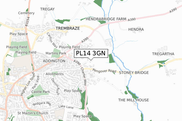
PL14 3GN is located in the Liskeard Central electoral ward, within the unitary authority of Cornwall and the English Parliamentary constituency of South East Cornwall. The Sub Integrated Care Board (ICB) Location is NHS Cornwall and the Isles of Scilly ICB - 11N and the police force is Devon & Cornwall. This postcode has been in use since August 2018.
PL14 3GN maps


Source: OS Open Zoomstack (Ordnance Survey)
Licence: Open Government Licence (requires attribution)
Attribution: Contains OS data © Crown copyright and database right 2025
Source: Open Postcode Geo
Licence: Open Government Licence (requires attribution)
Attribution: Contains OS data © Crown copyright and database right 2025; Contains Royal Mail data © Royal Mail copyright and database right 2025; Source: Office for National Statistics licensed under the Open Government Licence v.3.0
Licence: Open Government Licence (requires attribution)
Attribution: Contains OS data © Crown copyright and database right 2025
Source: Open Postcode Geo
Licence: Open Government Licence (requires attribution)
Attribution: Contains OS data © Crown copyright and database right 2025; Contains Royal Mail data © Royal Mail copyright and database right 2025; Source: Office for National Statistics licensed under the Open Government Licence v.3.0
PL14 3GN geodata
| Easting | 226257 |
| Northing | 65103 |
| Latitude | 50.459947 |
| Longitude | -4.449199 |
Where is PL14 3GN?
| Country | England |
| Postcode District | PL14 |
Politics
| Ward | Liskeard Central |
|---|---|
| Constituency | South East Cornwall |
House Prices
Sales of detached houses in PL14 3GN
4, ARIES HILL, LISKEARD, PL14 3GN 2024 31 OCT £324,950 |
3, ARIES HILL, LISKEARD, PL14 3GN 2024 6 SEP £360,000 |
2024 19 AUG £315,000 |
12, ARIES HILL, LISKEARD, PL14 3GN 2024 1 AUG £340,000 |
9, ARIES HILL, LISKEARD, PL14 3GN 2024 4 JUL £275,000 |
30, ARIES HILL, LISKEARD, PL14 3GN 2024 26 JAN £332,950 |
29, ARIES HILL, LISKEARD, PL14 3GN 2023 15 DEC £289,950 |
20, ARIES HILL, LISKEARD, PL14 3GN 2023 10 OCT £275,000 |
26, ARIES HILL, LISKEARD, PL14 3GN 2023 4 OCT £275,000 |
10, ARIES HILL, LISKEARD, PL14 3GN 2023 29 SEP £389,950 |
Source: HM Land Registry Price Paid Data
Licence: Contains HM Land Registry data © Crown copyright and database right 2025. This data is licensed under the Open Government Licence v3.0.
Licence: Contains HM Land Registry data © Crown copyright and database right 2025. This data is licensed under the Open Government Licence v3.0.
Transport
Nearest bus stops to PL14 3GN
| Charter Way | Addington | 136m |
| Pengover Road | Addington | 157m |
| Hospital (Clemo Road) | Liskeard | 167m |
| Liskeard Hospital | Liskeard | 188m |
| Quimperle Way (A390) | Liskeard | 233m |
Nearest railway stations to PL14 3GN
| Liskeard Station | 2.1km |
| Coombe Junction Halt (Station) | 2.8km |
| St Keyne Wishing Well Halt (Station) | 4.2km |
Deprivation
68.6% of English postcodes are less deprived than PL14 3GN:Food Standards Agency
Three nearest food hygiene ratings to PL14 3GN (metres)
Bumbles Day Nursery Ltd

Bumbles Day Nursery
213m
Liskeard Community Hospital

Clemo Road
223m
Kingston House Residential Home

Westlake Care
465m
➜ Get more ratings from the Food Standards Agency
Nearest post box to PL14 3GN
| Last Collection | |||
|---|---|---|---|
| Location | Mon-Fri | Sat | Distance |
| Market Street | 15:00 | 12:15 | 1,142m |
| Church Street | 15:00 | 12:15 | 1,149m |
| Barn Street | 16:30 | 12:00 | 1,462m |
PL14 3GN ITL and PL14 3GN LAU
The below table lists the International Territorial Level (ITL) codes (formerly Nomenclature of Territorial Units for Statistics (NUTS) codes) and Local Administrative Units (LAU) codes for PL14 3GN:
| ITL 1 Code | Name |
|---|---|
| TLK | South West (England) |
| ITL 2 Code | Name |
| TLK3 | Cornwall and Isles of Scilly |
| ITL 3 Code | Name |
| TLK30 | Cornwall and Isles of Scilly |
| LAU 1 Code | Name |
| E06000052 | Cornwall |
PL14 3GN census areas
The below table lists the Census Output Area (OA), Lower Layer Super Output Area (LSOA), and Middle Layer Super Output Area (MSOA) for PL14 3GN:
| Code | Name | |
|---|---|---|
| OA | E00094738 | |
| LSOA | E01018769 | Cornwall 016C |
| MSOA | E02003895 | Cornwall 016 |
Nearest postcodes to PL14 3GN
| PL14 3UD | St Matthews Meadow | 173m |
| PL14 3SZ | Martins Close | 184m |
| PL14 3NW | Pengover Road | 200m |
| PL14 3SX | Stephens Road | 204m |
| PL14 3TU | Kilmar Road | 226m |
| PL14 3TG | Treverbyn Close | 253m |
| PL14 3SY | Herring Road | 283m |
| PL14 3TA | Herring Close | 292m |
| PL14 3TE | Respryn Close | 292m |
| PL14 3NN | Green Lane | 303m |