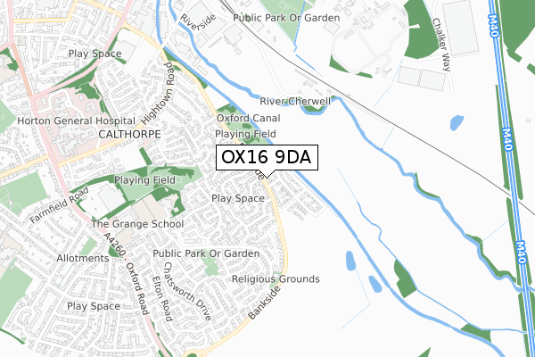
OX16 9DA open data databoard
OX16 9DA is located in the Banbury Calthorpe and Easington electoral ward, within the local authority district of Cherwell and the English Parliamentary constituency of Banbury. The Sub Integrated Care Board (ICB) Location is NHS Buckinghamshire, Oxfordshire and Berkshire West ICB - 10Q and the police force is Thames Valley. This postcode has been in use since June 2019.
OX16 9DA maps


Licence: Open Government Licence (requires attribution)
Attribution: Contains OS data © Crown copyright and database right 2025
Source: Open Postcode Geo
Licence: Open Government Licence (requires attribution)
Attribution: Contains OS data © Crown copyright and database right 2025; Contains Royal Mail data © Royal Mail copyright and database right 2025; Source: Office for National Statistics licensed under the Open Government Licence v.3.0
OX16 9DA geodata
| Easting | 446555 |
| Northing | 239389 |
| Latitude | 52.050952 |
| Longitude | -1.322497 |
Where is OX16 9DA?
| Country | England |
| Postcode District | OX16 |
Politics
| Ward | Banbury Calthorpe And Easington |
|---|---|
| Constituency | Banbury |
House Prices
Sales of detached houses in OX16 9DA
81, BANKSIDE, BANBURY, OX16 9DA 2020 3 DEC £379,050 |
2020 24 NOV £389,500 |
2020 13 NOV £345,000 |
2020 21 OCT £320,000 |
2020 21 OCT £370,000 |
2019 5 SEP £320,000 |
2019 5 SEP £370,000 |
Licence: Contains HM Land Registry data © Crown copyright and database right 2025. This data is licensed under the Open Government Licence v3.0.
Transport
Nearest bus stops to OX16 9DA
| Farm Way (Bankside) | Cherwell Heights | 188m |
| Farm Way (Bankside) | Cherwell Heights | 195m |
| Coppice Close (Bankside) | Cherwell Heights | 308m |
| Coppice Close (Bankside) | Cherwell Heights | 309m |
| Kedlestone Rise (Chatsworth Drive) | Cherwell Heights | 418m |
Nearest railway stations to OX16 9DA
| Banbury Station | 1.1km |
| Kings Sutton Station | 4.4km |
Broadband
Broadband access in OX16 9DA (2020 data)
| Percentage of properties with Next Generation Access | 87.5% |
| Percentage of properties with Superfast Broadband | 87.5% |
| Percentage of properties with Ultrafast Broadband | 81.3% |
| Percentage of properties with Full Fibre Broadband | 81.3% |
Superfast Broadband is between 30Mbps and 300Mbps
Ultrafast Broadband is > 300Mbps
Broadband limitations in OX16 9DA (2020 data)
| Percentage of properties unable to receive 2Mbps | 0.0% |
| Percentage of properties unable to receive 5Mbps | 0.0% |
| Percentage of properties unable to receive 10Mbps | 0.0% |
| Percentage of properties unable to receive 30Mbps | 0.0% |
Deprivation
11.2% of English postcodes are less deprived than OX16 9DA:Food Standards Agency
Three nearest food hygiene ratings to OX16 9DA (metres)


➜ Get more ratings from the Food Standards Agency
Nearest post box to OX16 9DA
| Last Collection | |||
|---|---|---|---|
| Location | Mon-Fri | Sat | Distance |
| Wood End | 17:00 | 08:00 | 151m |
| Chatsworth Drive Post Office | 17:40 | 12:00 | 450m |
| Western Crescent | 17:00 | 08:00 | 697m |
OX16 9DA ITL and OX16 9DA LAU
The below table lists the International Territorial Level (ITL) codes (formerly Nomenclature of Territorial Units for Statistics (NUTS) codes) and Local Administrative Units (LAU) codes for OX16 9DA:
| ITL 1 Code | Name |
|---|---|
| TLJ | South East (England) |
| ITL 2 Code | Name |
| TLJ1 | Berkshire, Buckinghamshire and Oxfordshire |
| ITL 3 Code | Name |
| TLJ14 | Oxfordshire CC |
| LAU 1 Code | Name |
| E07000177 | Cherwell |
OX16 9DA census areas
The below table lists the Census Output Area (OA), Lower Layer Super Output Area (LSOA), and Middle Layer Super Output Area (MSOA) for OX16 9DA:
| Code | Name | |
|---|---|---|
| OA | E00144862 | |
| LSOA | E01028426 | Cherwell 007A |
| MSOA | E02005927 | Cherwell 007 |
Nearest postcodes to OX16 9DA
| OX16 9SY | Bankside | 80m |
| OX16 9TA | Spinney Drive | 101m |
| OX16 9SZ | Bridle Close | 121m |
| OX16 9ST | Wood End | 169m |
| OX16 9SX | Bankside | 201m |
| OX16 9TB | Farm Way | 207m |
| OX16 9SU | Wood End | 212m |
| OX16 9YT | Hillside Close | 228m |
| OX16 9YF | Hillside Close | 235m |
| OX16 9SR | Meadow View | 247m |