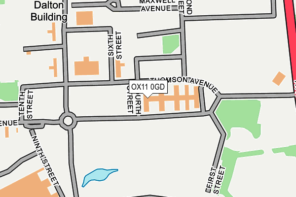
OX11 0GD is located in the Hendreds electoral ward, within the local authority district of Vale of White Horse and the English Parliamentary constituency of Wantage. The Sub Integrated Care Board (ICB) Location is NHS Buckinghamshire, Oxfordshire and Berkshire West ICB - 10Q and the police force is Thames Valley. This postcode has been in use since February 2017.


GetTheData
Source: OS OpenMap – Local (Ordnance Survey)
Source: OS VectorMap District (Ordnance Survey)
Licence: Open Government Licence (requires attribution)
| Easting | 447845 |
| Northing | 187181 |
| Latitude | 51.581468 |
| Longitude | -1.310880 |
GetTheData
Source: Open Postcode Geo
Licence: Open Government Licence
| Country | England |
| Postcode District | OX11 |
➜ See where OX11 is on a map | |
GetTheData
Source: Land Registry Price Paid Data
Licence: Open Government Licence
| Ward | Hendreds |
| Constituency | Wantage |
GetTheData
Source: ONS Postcode Database
Licence: Open Government Licence
| Thompson Entrance (A4185) | Harwell Campus | 414m |
| Thompson Entrance (A4185) | Harwell Campus | 454m |
| Curie Entrance (A4185) | Harwell Campus | 547m |
| Eighth Street (Fermi Avenue) | Harwell Campus | 547m |
| Eighth Street (Fermi Avenue) | Harwell Campus | 560m |
| Didcot Parkway Station | 5.7km |
GetTheData
Source: NaPTAN
Licence: Open Government Licence
GetTheData
Source: ONS Postcode Database
Licence: Open Government Licence


➜ Get more ratings from the Food Standards Agency
GetTheData
Source: Food Standards Agency
Licence: FSA terms & conditions
| Last Collection | |||
|---|---|---|---|
| Location | Mon-Fri | Sat | Distance |
| Icknield Way Post Office | 16:30 | 08:45 | 240m |
| Avon Way | 16:00 | 08:00 | 595m |
| Southend Icknield Way | 16:00 | 07:00 | 1,356m |
GetTheData
Source: Dracos
Licence: Creative Commons Attribution-ShareAlike
The below table lists the International Territorial Level (ITL) codes (formerly Nomenclature of Territorial Units for Statistics (NUTS) codes) and Local Administrative Units (LAU) codes for OX11 0GD:
| ITL 1 Code | Name |
|---|---|
| TLJ | South East (England) |
| ITL 2 Code | Name |
| TLJ1 | Berkshire, Buckinghamshire and Oxfordshire |
| ITL 3 Code | Name |
| TLJ14 | Oxfordshire CC |
| LAU 1 Code | Name |
| E07000180 | Vale of White Horse |
GetTheData
Source: ONS Postcode Directory
Licence: Open Government Licence
The below table lists the Census Output Area (OA), Lower Layer Super Output Area (LSOA), and Middle Layer Super Output Area (MSOA) for OX11 0GD:
| Code | Name | |
|---|---|---|
| OA | E00146331 | |
| LSOA | E01028729 | Vale of White Horse 015D |
| MSOA | E02005992 | Vale of White Horse 015 |
GetTheData
Source: ONS Postcode Directory
Licence: Open Government Licence
| OX11 0QR | Fermi Avenue | 489m |
| OX11 0PE | North Drive | 590m |
| OX11 0PD | North Drive | 693m |
| OX11 0PW | Severn Road | 1088m |
| OX11 0TX | Spa Street | 1167m |
| OX11 0TZ | Potteries Lane | 1227m |
| OX11 0TW | The Rookery | 1231m |
| OX11 0UD | Baths Road | 1240m |
| OX11 0UA | Pathfinder View | 1248m |
| OX11 0TU | Villa Road | 1260m |
GetTheData
Source: Open Postcode Geo; Land Registry Price Paid Data
Licence: Open Government Licence