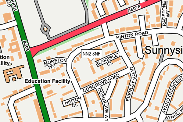
NN2 8NF is located in the Kingsthorpe North electoral ward, within the unitary authority of West Northamptonshire and the English Parliamentary constituency of Northampton North. The Sub Integrated Care Board (ICB) Location is NHS Northamptonshire ICB - 78H and the police force is Northamptonshire. This postcode has been in use since July 2017.


GetTheData
Source: OS OpenMap – Local (Ordnance Survey)
Source: OS VectorMap District (Ordnance Survey)
Licence: Open Government Licence (requires attribution)
| Easting | 474951 |
| Northing | 264370 |
| Latitude | 52.272400 |
| Longitude | -0.902967 |
GetTheData
Source: Open Postcode Geo
Licence: Open Government Licence
| Country | England |
| Postcode District | NN2 |
➜ See where NN2 is on a map ➜ Where is Northampton? | |
GetTheData
Source: Land Registry Price Paid Data
Licence: Open Government Licence
| Ward | Kingsthorpe North |
| Constituency | Northampton North |
GetTheData
Source: ONS Postcode Database
Licence: Open Government Licence
| Kingsthorpe Cemetery (Harborough Road) | Whitehills | 134m |
| Greenfields School (Harborough Road) | Kingsthorpe | 140m |
| Kingsthorpe Cemetery (Harborough Road) | Whitehills | 201m |
| Greenfields School (Harborough Road) | Kingsthorpe | 245m |
| Syresham Way (Holly Lodge Drive) | Obelisk Rise | 272m |
| Northampton Station | 3.9km |
GetTheData
Source: NaPTAN
Licence: Open Government Licence
| Median download speed | 100.0Mbps |
| Average download speed | 91.7Mbps |
| Maximum download speed | 100.00Mbps |
Ofcom does not currently provide upload speed data for NN2 8NF. This is because there are less than four broadband connections in this postcode.
GetTheData
Source: Ofcom
Licence: Ofcom Terms of Use (requires attribution)
GetTheData
Source: ONS Postcode Database
Licence: Open Government Licence


➜ Get more ratings from the Food Standards Agency
GetTheData
Source: Food Standards Agency
Licence: FSA terms & conditions
| Last Collection | |||
|---|---|---|---|
| Location | Mon-Fri | Sat | Distance |
| Harborough Road | 17:30 | 11:30 | 369m |
| Link Road | 17:00 | 12:15 | 489m |
| Helmdon Road | 17:30 | 12:15 | 507m |
GetTheData
Source: Dracos
Licence: Creative Commons Attribution-ShareAlike
The below table lists the International Territorial Level (ITL) codes (formerly Nomenclature of Territorial Units for Statistics (NUTS) codes) and Local Administrative Units (LAU) codes for NN2 8NF:
| ITL 1 Code | Name |
|---|---|
| TLF | East Midlands (England) |
| ITL 2 Code | Name |
| TLF2 | Leicestershire, Rutland and Northamptonshire |
| ITL 3 Code | Name |
| TLF24 | West Northamptonshire |
| LAU 1 Code | Name |
| E07000154 | Northampton |
GetTheData
Source: ONS Postcode Directory
Licence: Open Government Licence
The below table lists the Census Output Area (OA), Lower Layer Super Output Area (LSOA), and Middle Layer Super Output Area (MSOA) for NN2 8NF:
| Code | Name | |
|---|---|---|
| OA | E00138088 | |
| LSOA | E01027143 | Northampton 003A |
| MSOA | E02005652 | Northampton 003 |
GetTheData
Source: ONS Postcode Directory
Licence: Open Government Licence
| NN2 8LT | Harborough Road | 56m |
| NN2 8ND | Pasteur Close | 93m |
| NN2 8NE | Osler Close | 109m |
| NN2 8NB | Jenner Crescent | 144m |
| NN2 8PD | Moreton Way | 163m |
| NN2 8DT | Birch Barn Way | 236m |
| NN2 8ED | Gorse Close | 257m |
| NN2 8AY | Poachers Way | 260m |
| NN2 8DR | Liddington Way | 261m |
| NN2 8LS | Harborough Road North | 266m |
GetTheData
Source: Open Postcode Geo; Land Registry Price Paid Data
Licence: Open Government Licence