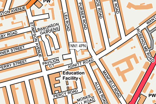
NN1 4PN is located in the Abington and Phippsville electoral ward, within the unitary authority of West Northamptonshire and the English Parliamentary constituency of Northampton North. The Sub Integrated Care Board (ICB) Location is NHS Northamptonshire ICB - 78H and the police force is Northamptonshire. This postcode has been in use since February 2017.


GetTheData
Source: OS OpenMap – Local (Ordnance Survey)
Source: OS VectorMap District (Ordnance Survey)
Licence: Open Government Licence (requires attribution)
| Easting | 476910 |
| Northing | 261450 |
| Latitude | 52.245883 |
| Longitude | -0.874926 |
GetTheData
Source: Open Postcode Geo
Licence: Open Government Licence
| Country | England |
| Postcode District | NN1 |
➜ See where NN1 is on a map ➜ Where is Northampton? | |
GetTheData
Source: Land Registry Price Paid Data
Licence: Open Government Licence
| Ward | Abington And Phippsville |
| Constituency | Northampton North |
GetTheData
Source: ONS Postcode Database
Licence: Open Government Licence
| Stimpson Avenue Primary School (Stimpson Avenue) | Abington | 142m |
| Stimpson Avenue Primary School (Stimpson Avenue) | Abington | 168m |
| Westleigh Close (Stimpson Avenue) | Abington | 236m |
| Billington Street (Stimpson Avenue) | Abington | 242m |
| Billington Street (Stimpson Avenue) | Abington | 284m |
| Northampton Station | 2.4km |
GetTheData
Source: NaPTAN
Licence: Open Government Licence
| Percentage of properties with Next Generation Access | 100.0% |
| Percentage of properties with Superfast Broadband | 100.0% |
| Percentage of properties with Ultrafast Broadband | 0.0% |
| Percentage of properties with Full Fibre Broadband | 0.0% |
Superfast Broadband is between 30Mbps and 300Mbps
Ultrafast Broadband is > 300Mbps
| Percentage of properties unable to receive 2Mbps | 0.0% |
| Percentage of properties unable to receive 5Mbps | 0.0% |
| Percentage of properties unable to receive 10Mbps | 0.0% |
| Percentage of properties unable to receive 30Mbps | 0.0% |
GetTheData
Source: Ofcom
Licence: Ofcom Terms of Use (requires attribution)
GetTheData
Source: ONS Postcode Database
Licence: Open Government Licence


➜ Get more ratings from the Food Standards Agency
GetTheData
Source: Food Standards Agency
Licence: FSA terms & conditions
| Last Collection | |||
|---|---|---|---|
| Location | Mon-Fri | Sat | Distance |
| Adnitt Road | 17:30 | 11:30 | 74m |
| Abington Ave | 17:30 | 11:30 | 295m |
| Abington Park Tso | 17:30 | 11:30 | 296m |
GetTheData
Source: Dracos
Licence: Creative Commons Attribution-ShareAlike
The below table lists the International Territorial Level (ITL) codes (formerly Nomenclature of Territorial Units for Statistics (NUTS) codes) and Local Administrative Units (LAU) codes for NN1 4PN:
| ITL 1 Code | Name |
|---|---|
| TLF | East Midlands (England) |
| ITL 2 Code | Name |
| TLF2 | Leicestershire, Rutland and Northamptonshire |
| ITL 3 Code | Name |
| TLF24 | West Northamptonshire |
| LAU 1 Code | Name |
| E07000154 | Northampton |
GetTheData
Source: ONS Postcode Directory
Licence: Open Government Licence
The below table lists the Census Output Area (OA), Lower Layer Super Output Area (LSOA), and Middle Layer Super Output Area (MSOA) for NN1 4PN:
| Code | Name | |
|---|---|---|
| OA | E00138043 | |
| LSOA | E01027132 | Northampton 022A |
| MSOA | E02005671 | Northampton 022 |
GetTheData
Source: ONS Postcode Directory
Licence: Open Government Licence
| NN1 4NQ | Adnitt Road | 40m |
| NN1 4PP | Lea Road | 44m |
| NN1 4NG | Adnitt Road | 61m |
| NN1 4LF | Adnitt Road | 80m |
| NN1 4NF | Adnitt Road | 83m |
| NN1 4NH | Adnitt Road | 87m |
| NN1 4NZ | Baronson Gardens | 116m |
| NN1 4ND | Stimpson Avenue | 121m |
| NN1 4NU | Baronson Gardens | 127m |
| NN1 4PE | Lea Road | 127m |
GetTheData
Source: Open Postcode Geo; Land Registry Price Paid Data
Licence: Open Government Licence