Property/Postcode Data Search:
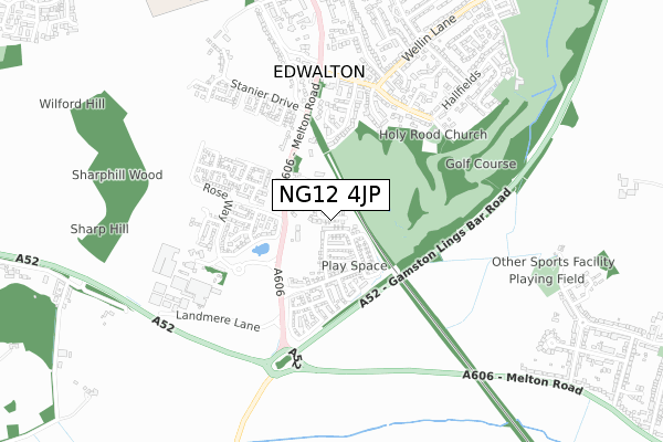
NG12 4JP maps, stats, and open data
NG12 4JP is located in the Edwalton electoral ward, within the local authority district of Rushcliffe and the English Parliamentary constituency of Rushcliffe. The Sub Integrated Care Board (ICB) Location is NHS Nottingham and Nottinghamshire ICB - 52R and the police force is Nottinghamshire. This postcode has been in use since December 2019.
NG12 4JP maps


Source: OS Open Zoomstack (Ordnance Survey)
Licence: Open Government Licence (requires attribution)
Attribution: Contains OS data © Crown copyright and database right 2025
Source: Open Postcode Geo
Licence: Open Government Licence (requires attribution)
Attribution: Contains OS data © Crown copyright and database right 2025; Contains Royal Mail data © Royal Mail copyright and database right 2025; Source: Office for National Statistics licensed under the Open Government Licence v.3.0
Licence: Open Government Licence (requires attribution)
Attribution: Contains OS data © Crown copyright and database right 2025
Source: Open Postcode Geo
Licence: Open Government Licence (requires attribution)
Attribution: Contains OS data © Crown copyright and database right 2025; Contains Royal Mail data © Royal Mail copyright and database right 2025; Source: Office for National Statistics licensed under the Open Government Licence v.3.0
NG12 4JP geodata
| Easting | 459454 |
| Northing | 334699 |
| Latitude | 52.906465 |
| Longitude | -1.117454 |
Where is NG12 4JP?
| Country | England |
| Postcode District | NG12 |
Politics
| Ward | Edwalton |
|---|---|
| Constituency | Rushcliffe |
House Prices
Sales of detached houses in NG12 4JP
1, ROBIN GARDENS, EDWALTON, NOTTINGHAM, NG12 4JP 2025 18 JUL £715,000 |
2023 1 DEC £865,000 |
7, ROBIN GARDENS, EDWALTON, NOTTINGHAM, NG12 4JP 2021 29 JUN £670,000 |
12, ROBIN GARDENS, EDWALTON, NOTTINGHAM, NG12 4JP 2021 10 JUN £500,000 |
11, ROBIN GARDENS, EDWALTON, NOTTINGHAM, NG12 4JP 2020 11 DEC £520,000 |
9, ROBIN GARDENS, EDWALTON, NOTTINGHAM, NG12 4JP 2020 16 OCT £520,000 |
3, ROBIN GARDENS, EDWALTON, NOTTINGHAM, NG12 4JP 2020 3 SEP £600,000 |
10, ROBIN GARDENS, EDWALTON, NOTTINGHAM, NG12 4JP 2020 27 JUL £675,000 |
4, ROBIN GARDENS, EDWALTON, NOTTINGHAM, NG12 4JP 2020 26 JUN £575,000 |
8, ROBIN GARDENS, EDWALTON, NOTTINGHAM, NG12 4JP 2020 27 MAR £780,000 |
Source: HM Land Registry Price Paid Data
Licence: Contains HM Land Registry data © Crown copyright and database right 2025. This data is licensed under the Open Government Licence v3.0.
Licence: Contains HM Land Registry data © Crown copyright and database right 2025. This data is licensed under the Open Government Licence v3.0.
Transport
Nearest bus stops to NG12 4JP
| Hill Farm Court (Melton Road) | Edwalton | 223m |
| Hill Farm Court (Melton Road) | Edwalton | 236m |
| Wheatcrofts (Melton Road) | Edwalton | 426m |
| Wheatcrofts (Melton Road) | Edwalton | 426m |
| Edwalton Hall (Melton Road) | Edwalton | 560m |
Nearest railway stations to NG12 4JP
| Nottingham Station | 4.9km |
Deprivation
0.6% of English postcodes are less deprived than NG12 4JP:Food Standards Agency
Three nearest food hygiene ratings to NG12 4JP (metres)
Edwalton Day Nursery

227 Melton Road
101m
The Street Kitchen - Notcutts Ltd

Notcutts Ltd
581m
Rattle And Roll Performance At Rosecliffe Spencer Academy

Rosecliffe Spencer Academy
581m
➜ Get more ratings from the Food Standards Agency
Nearest post box to NG12 4JP
| Last Collection | |||
|---|---|---|---|
| Location | Mon-Fri | Sat | Distance |
| Edwalton Hall | 17:00 | 11:00 | 539m |
| Edwalton Post Office | 17:00 | 12:00 | 757m |
| Woodview | 17:00 | 12:00 | 1,088m |
NG12 4JP ITL and NG12 4JP LAU
The below table lists the International Territorial Level (ITL) codes (formerly Nomenclature of Territorial Units for Statistics (NUTS) codes) and Local Administrative Units (LAU) codes for NG12 4JP:
| ITL 1 Code | Name |
|---|---|
| TLF | East Midlands (England) |
| ITL 2 Code | Name |
| TLF1 | Derbyshire and Nottinghamshire |
| ITL 3 Code | Name |
| TLF16 | South Nottinghamshire |
| LAU 1 Code | Name |
| E07000176 | Rushcliffe |
NG12 4JP census areas
The below table lists the Census Output Area (OA), Lower Layer Super Output Area (LSOA), and Middle Layer Super Output Area (MSOA) for NG12 4JP:
| Code | Name | |
|---|---|---|
| OA | E00144575 | |
| LSOA | E01028373 | Rushcliffe 008B |
| MSOA | E02005913 | Rushcliffe 008 |
Nearest postcodes to NG12 4JP
| NG12 4DB | Melton Road | 130m |
| NG12 4DP | Hill Farm Court | 140m |
| NG12 4DD | Melton Road | 314m |
| NG12 4FB | Birkdale Close | 343m |
| NG12 4AR | The Paddocks | 425m |
| NG12 4AD | Village Close | 434m |
| NG12 4HF | Edwalton Hall Mews | 469m |
| NG12 4HE | Village Street | 483m |
| NG12 4AE | Village Street | 495m |
| NG12 4HG | Village Street | 498m |