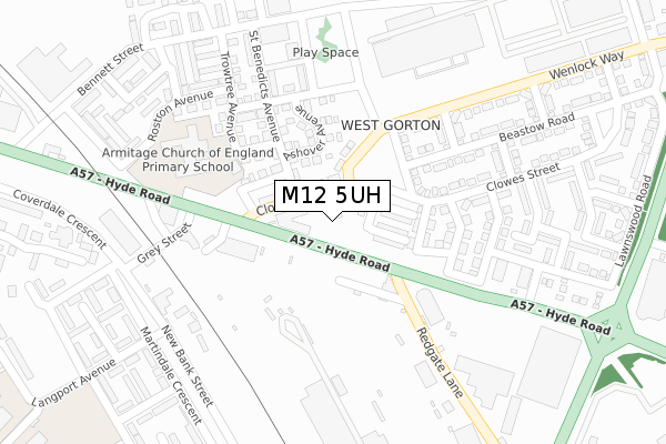
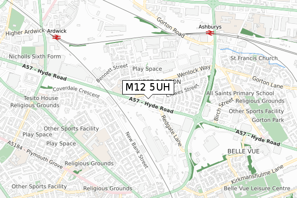
M12 5UH is located in the Ardwick electoral ward, within the metropolitan district of Manchester and the English Parliamentary constituency of Manchester Central. The Sub Integrated Care Board (ICB) Location is NHS Greater Manchester ICB - 14L and the police force is Greater Manchester. This postcode has been in use since April 2020.


GetTheData
Source: OS Open Zoomstack (Ordnance Survey)
Licence: Open Government Licence (requires attribution)
Attribution: Contains OS data © Crown copyright and database right 2025
Source: Open Postcode Geo
Licence: Open Government Licence (requires attribution)
Attribution: Contains OS data © Crown copyright and database right 2025; Contains Royal Mail data © Royal Mail copyright and database right 2025; Source: Office for National Statistics licensed under the Open Government Licence v.3.0
| Easting | 386656 |
| Northing | 396720 |
| Latitude | 53.467064 |
| Longitude | -2.202473 |
GetTheData
Source: Open Postcode Geo
Licence: Open Government Licence
| Country | England |
| Postcode District | M12 |
➜ See where M12 is on a map ➜ Where is Manchester? | |
GetTheData
Source: Land Registry Price Paid Data
Licence: Open Government Licence
| Ward | Ardwick |
| Constituency | Manchester Central |
GetTheData
Source: ONS Postcode Database
Licence: Open Government Licence
4, LUDLOW CLOSE, MANCHESTER, M12 5UH 2020 28 FEB £254,995 |
GetTheData
Source: HM Land Registry Price Paid Data
Licence: Contains HM Land Registry data © Crown copyright and database right 2025. This data is licensed under the Open Government Licence v3.0.
| Hyde Rd/Clowes St (Hyde Rd) | West Gorton | 67m |
| Clowes St/Ashover Ave (Clowes St) | West Gorton | 67m |
| Kniverton Rd/Armitage Ct (Kniverton Rd) | West Gorton | 145m |
| Wenlock Way/Icl (Wenlock Way) | West Gorton | 170m |
| Hyde Rd/Redgate Ln (Hyde Rd) | West Gorton | 193m |
| Ashburys Station | 0.7km |
| Ardwick Station | 0.9km |
| Belle Vue Station | 1.5km |
GetTheData
Source: NaPTAN
Licence: Open Government Licence
GetTheData
Source: ONS Postcode Database
Licence: Open Government Licence


➜ Get more ratings from the Food Standards Agency
GetTheData
Source: Food Standards Agency
Licence: FSA terms & conditions
| Last Collection | |||
|---|---|---|---|
| Location | Mon-Fri | Sat | Distance |
| Kinley Street | 17:30 | 12:00 | 126m |
| West Gorton | 17:30 | 12:00 | 306m |
| Whixall Close | 17:30 | 12:00 | 363m |
GetTheData
Source: Dracos
Licence: Creative Commons Attribution-ShareAlike
The below table lists the International Territorial Level (ITL) codes (formerly Nomenclature of Territorial Units for Statistics (NUTS) codes) and Local Administrative Units (LAU) codes for M12 5UH:
| ITL 1 Code | Name |
|---|---|
| TLD | North West (England) |
| ITL 2 Code | Name |
| TLD3 | Greater Manchester |
| ITL 3 Code | Name |
| TLD33 | Manchester |
| LAU 1 Code | Name |
| E08000003 | Manchester |
GetTheData
Source: ONS Postcode Directory
Licence: Open Government Licence
The below table lists the Census Output Area (OA), Lower Layer Super Output Area (LSOA), and Middle Layer Super Output Area (MSOA) for M12 5UH:
| Code | Name | |
|---|---|---|
| OA | E00025620 | |
| LSOA | E01005067 | Manchester 020A |
| MSOA | E02001064 | Manchester 020 |
GetTheData
Source: ONS Postcode Directory
Licence: Open Government Licence
| M12 5EA | Pollitt Close | 37m |
| M12 5WH | Wenlock Way | 81m |
| M12 5DQ | Ainsdale Street | 87m |
| M12 5EE | Fairhaven Street | 91m |
| M12 5EB | Clowes Street | 162m |
| M12 5LR | Trowtree Avenue | 219m |
| M12 5FR | Donnison Street | 219m |
| M12 5EW | Hoyland Close | 282m |
| M12 4RY | Redgate Lane | 283m |
| M12 5LW | Whixhall Avenue | 317m |
GetTheData
Source: Open Postcode Geo; Land Registry Price Paid Data
Licence: Open Government Licence