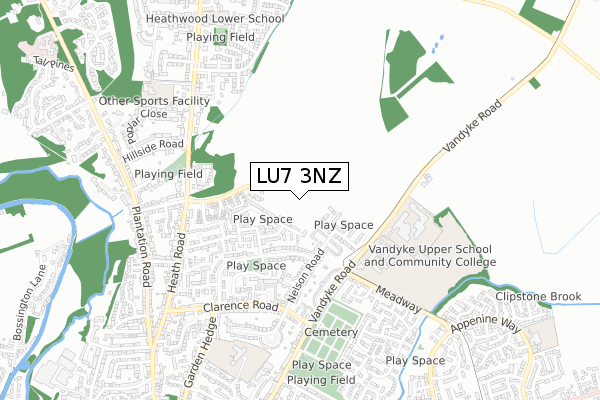
LU7 3NZ maps, stats, and open data
LU7 3NZ is located in the Leighton-Linslade North electoral ward, within the unitary authority of Central Bedfordshire and the English Parliamentary constituency of South West Bedfordshire. The Sub Integrated Care Board (ICB) Location is NHS Bedfordshire, Luton and Milton Keynes ICB - M1J4Y and the police force is Bedfordshire. This postcode has been in use since June 2019.
LU7 3NZ maps


Licence: Open Government Licence (requires attribution)
Attribution: Contains OS data © Crown copyright and database right 2025
Source: Open Postcode Geo
Licence: Open Government Licence (requires attribution)
Attribution: Contains OS data © Crown copyright and database right 2025; Contains Royal Mail data © Royal Mail copyright and database right 2025; Source: Office for National Statistics licensed under the Open Government Licence v.3.0
LU7 3NZ geodata
| Easting | 492852 |
| Northing | 226364 |
| Latitude | 51.928068 |
| Longitude | -0.651025 |
Where is LU7 3NZ?
| Country | England |
| Postcode District | LU7 |
Politics
| Ward | Leighton-linslade North |
|---|---|
| Constituency | South West Bedfordshire |
House Prices
Sales of detached houses in LU7 3NZ
5, BOLTON LANE, LEIGHTON BUZZARD, LU7 3NZ 2023 24 APR £449,950 |
3, BOLTON LANE, LEIGHTON BUZZARD, LU7 3NZ 2023 20 APR £539,950 |
7, BOLTON LANE, LEIGHTON BUZZARD, LU7 3NZ 2023 24 FEB £539,950 |
12, BOLTON LANE, LEIGHTON BUZZARD, LU7 3NZ 2023 24 FEB £599,950 |
14, BOLTON LANE, LEIGHTON BUZZARD, LU7 3NZ 2022 24 NOV £499,950 |
1, BOLTON LANE, LEIGHTON BUZZARD, LU7 3NZ 2022 11 FEB £446,950 |
2, BOLTON LANE, LEIGHTON BUZZARD, LU7 3NZ 2022 21 JAN £447,950 |
➜ Leighton Buzzard house prices
Licence: Contains HM Land Registry data © Crown copyright and database right 2025. This data is licensed under the Open Government Licence v3.0.
Transport
Nearest bus stops to LU7 3NZ
| Nelson Road | Leighton Buzzard | 330m |
| Churchill Road | Leighton Buzzard | 335m |
| Nelson Road | Leighton Buzzard | 342m |
| Churchill Road | Leighton Buzzard | 345m |
| Hornbeam Close (Meadway) | Leighton Buzzard | 354m |
Nearest railway stations to LU7 3NZ
| Leighton Buzzard Station | 2.2km |
Deprivation
2% of English postcodes are less deprived than LU7 3NZ:Food Standards Agency
Three nearest food hygiene ratings to LU7 3NZ (metres)


➜ Get more ratings from the Food Standards Agency
Nearest post box to LU7 3NZ
| Last Collection | |||
|---|---|---|---|
| Location | Mon-Fri | Sat | Distance |
| Nelson Road | 17:00 | 12:00 | 174m |
| Clarence Road | 17:30 | 12:30 | 450m |
| Broomshill Road | 17:00 | 12:00 | 542m |
LU7 3NZ ITL and LU7 3NZ LAU
The below table lists the International Territorial Level (ITL) codes (formerly Nomenclature of Territorial Units for Statistics (NUTS) codes) and Local Administrative Units (LAU) codes for LU7 3NZ:
| ITL 1 Code | Name |
|---|---|
| TLH | East |
| ITL 2 Code | Name |
| TLH2 | Bedfordshire and Hertfordshire |
| ITL 3 Code | Name |
| TLH25 | Central Bedfordshire |
| LAU 1 Code | Name |
| E06000056 | Central Bedfordshire |
LU7 3NZ census areas
The below table lists the Census Output Area (OA), Lower Layer Super Output Area (LSOA), and Middle Layer Super Output Area (MSOA) for LU7 3NZ:
| Code | Name | |
|---|---|---|
| OA | E00088886 | |
| LSOA | E01017606 | Central Bedfordshire 020D |
| MSOA | E02003638 | Central Bedfordshire 020 |
Nearest postcodes to LU7 3NZ
| LU7 3DZ | Blenheim Road | 115m |
| LU7 3BY | Wellington Way | 146m |
| LU7 3EG | Nelson Road | 190m |
| LU7 3EF | Nelson Road | 194m |
| LU7 3EB | Churchill Road | 209m |
| LU7 3BX | Drakes Avenue | 233m |
| LU7 3ED | Churchill Road | 237m |
| LU7 3AF | Drakes Avenue | 279m |
| LU7 3EE | Nelson Road | 298m |
| LU7 3HS | Vandyke Road | 335m |