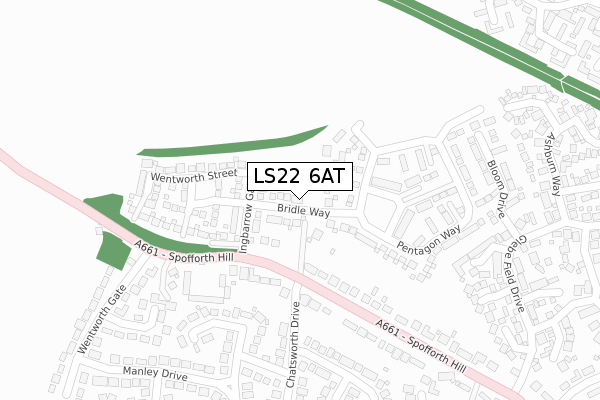
LS22 6AT maps, stats, and open data
LS22 6AT is located in the Wetherby electoral ward, within the metropolitan district of Leeds and the English Parliamentary constituency of Elmet and Rothwell. The Sub Integrated Care Board (ICB) Location is NHS West Yorkshire ICB - 15F and the police force is West Yorkshire. This postcode has been in use since November 2017.
LS22 6AT maps


Licence: Open Government Licence (requires attribution)
Attribution: Contains OS data © Crown copyright and database right 2025
Source: Open Postcode Geo
Licence: Open Government Licence (requires attribution)
Attribution: Contains OS data © Crown copyright and database right 2025; Contains Royal Mail data © Royal Mail copyright and database right 2025; Source: Office for National Statistics licensed under the Open Government Licence v.3.0
LS22 6AT geodata
| Easting | 439264 |
| Northing | 448982 |
| Latitude | 53.935492 |
| Longitude | -1.403435 |
Where is LS22 6AT?
| Country | England |
| Postcode District | LS22 |
Politics
| Ward | Wetherby |
|---|---|
| Constituency | Elmet And Rothwell |
House Prices
Sales of detached houses in LS22 6AT
2021 17 JUN £530,000 |
9, BRIDLE WAY, WETHERBY, LS22 6AT 2019 31 OCT £714,995 |
13, BRIDLE WAY, WETHERBY, LS22 6AT 2019 30 AUG £509,995 |
11, BRIDLE WAY, WETHERBY, LS22 6AT 2019 8 AUG £484,995 |
15, BRIDLE WAY, WETHERBY, LS22 6AT 2019 26 JUL £334,995 |
12, BRIDLE WAY, WETHERBY, LS22 6AT 2019 25 JAN £664,995 |
10, BRIDLE WAY, WETHERBY, LS22 6AT 2018 14 DEC £699,995 |
2018 24 MAY £479,995 |
8, BRIDLE WAY, WETHERBY, LS22 6AT 2018 26 JAN £649,995 |
1, BRIDLE WAY, WETHERBY, LS22 6AT 2018 19 JAN £469,995 |
Licence: Contains HM Land Registry data © Crown copyright and database right 2025. This data is licensed under the Open Government Licence v3.0.
Transport
Nearest bus stops to LS22 6AT
| Spofforth Hill Chatsworth Drive (Spofforth Hill) | Wetherby | 162m |
| Spofforth Hill | Wetherby | 227m |
| Harrogate Road Wentworth Gate (Harrogate Road) | Wetherby | 318m |
| Harrogate Road | Wetherby | 332m |
| Spofforth Hill Glebe Field Drive (Spofforth Hill) | Wetherby | 407m |
Broadband
Broadband access in LS22 6AT (2020 data)
| Percentage of properties with Next Generation Access | 100.0% |
| Percentage of properties with Superfast Broadband | 100.0% |
| Percentage of properties with Ultrafast Broadband | 100.0% |
| Percentage of properties with Full Fibre Broadband | 100.0% |
Superfast Broadband is between 30Mbps and 300Mbps
Ultrafast Broadband is > 300Mbps
Broadband limitations in LS22 6AT (2020 data)
| Percentage of properties unable to receive 2Mbps | 0.0% |
| Percentage of properties unable to receive 5Mbps | 0.0% |
| Percentage of properties unable to receive 10Mbps | 0.0% |
| Percentage of properties unable to receive 30Mbps | 0.0% |
Deprivation
1.8% of English postcodes are less deprived than LS22 6AT:Food Standards Agency
Three nearest food hygiene ratings to LS22 6AT (metres)


➜ Get more ratings from the Food Standards Agency
Nearest post box to LS22 6AT
| Last Collection | |||
|---|---|---|---|
| Location | Mon-Fri | Sat | Distance |
| Chatsworth Drive | 17:30 | 12:45 | 176m |
| Spofforth Hill | 17:30 | 12:45 | 553m |
| Wharfe Grove/Linton Road | 17:30 | 09:45 | 757m |
LS22 6AT ITL and LS22 6AT LAU
The below table lists the International Territorial Level (ITL) codes (formerly Nomenclature of Territorial Units for Statistics (NUTS) codes) and Local Administrative Units (LAU) codes for LS22 6AT:
| ITL 1 Code | Name |
|---|---|
| TLE | Yorkshire and The Humber |
| ITL 2 Code | Name |
| TLE4 | West Yorkshire |
| ITL 3 Code | Name |
| TLE42 | Leeds |
| LAU 1 Code | Name |
| E08000035 | Leeds |
LS22 6AT census areas
The below table lists the Census Output Area (OA), Lower Layer Super Output Area (LSOA), and Middle Layer Super Output Area (MSOA) for LS22 6AT:
| Code | Name | |
|---|---|---|
| OA | E00059016 | |
| LSOA | E01011702 | Leeds 001D |
| MSOA | E02002330 | Leeds 001 |
Nearest postcodes to LS22 6AT
| LS22 6TY | Leconfield Court | 228m |
| LS22 6XH | Carlton Approach | 255m |
| LS22 6SF | Spofforth Hill | 259m |
| LS22 6XJ | Burnham Court | 305m |
| LS22 6WE | Glebe Field Chase | 306m |
| LS22 6XY | Chatsworth Drive | 329m |
| LS22 6XZ | Marston Way | 334m |
| LS22 6XE | Farndale Close | 335m |
| LS22 6XQ | Manley Drive | 365m |
| LS22 6WH | Glebe Field Garth | 368m |