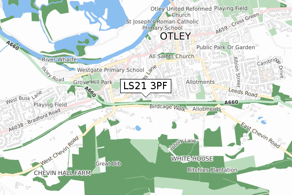
LS21 3PF maps, stats, and open data
LS21 3PF is located in the Otley & Yeadon electoral ward, within the metropolitan district of Leeds and the English Parliamentary constituency of Leeds North West. The Sub Integrated Care Board (ICB) Location is NHS West Yorkshire ICB - 15F and the police force is West Yorkshire. This postcode has been in use since October 2017.
LS21 3PF maps


Licence: Open Government Licence (requires attribution)
Attribution: Contains OS data © Crown copyright and database right 2025
Source: Open Postcode Geo
Licence: Open Government Licence (requires attribution)
Attribution: Contains OS data © Crown copyright and database right 2025; Contains Royal Mail data © Royal Mail copyright and database right 2025; Source: Office for National Statistics licensed under the Open Government Licence v.3.0
LS21 3PF geodata
| Easting | 419924 |
| Northing | 445017 |
| Latitude | 53.900956 |
| Longitude | -1.698264 |
Where is LS21 3PF?
| Country | England |
| Postcode District | LS21 |
Politics
| Ward | Otley & Yeadon |
|---|---|
| Constituency | Leeds North West |
House Prices
Sales of detached houses in LS21 3PF
2019 25 NOV £490,000 |
2019 20 SEP £575,000 |
2019 12 SEP £540,000 |
2019 7 JUN £400,000 |
2019 1 MAY £505,000 |
2018 25 SEP £100,000 |
2018 25 SEP £100,000 |
2018 29 AUG £495,000 |
3, WHITELEY CROFT GARDENS, OTLEY, LS21 3PF 2018 15 AUG £495,000 |
Licence: Contains HM Land Registry data © Crown copyright and database right 2025. This data is licensed under the Open Government Licence v3.0.
Transport
Nearest bus stops to LS21 3PF
| Burras Lane Granville Mount (Burras Lane) | Otley | 152m |
| Burras Lane Granville Mount (Burras Lane) | Otley | 177m |
| Waitrose Supermarket (Waitrose Supermarket Grounds) | Otley | 242m |
| Piper Lane | Otley | 332m |
| Piper Lane | Otley | 345m |
Nearest railway stations to LS21 3PF
| Menston Station | 2.6km |
| Guiseley Station | 3km |
| Burley-in-Wharfedale Station | 3.7km |
Broadband
Broadband access in LS21 3PF (2020 data)
| Percentage of properties with Next Generation Access | 100.0% |
| Percentage of properties with Superfast Broadband | 88.9% |
| Percentage of properties with Ultrafast Broadband | 0.0% |
| Percentage of properties with Full Fibre Broadband | 0.0% |
Superfast Broadband is between 30Mbps and 300Mbps
Ultrafast Broadband is > 300Mbps
Broadband limitations in LS21 3PF (2020 data)
| Percentage of properties unable to receive 2Mbps | 0.0% |
| Percentage of properties unable to receive 5Mbps | 0.0% |
| Percentage of properties unable to receive 10Mbps | 0.0% |
| Percentage of properties unable to receive 30Mbps | 11.1% |
Deprivation
32.1% of English postcodes are less deprived than LS21 3PF:Food Standards Agency
Three nearest food hygiene ratings to LS21 3PF (metres)


➜ Get more ratings from the Food Standards Agency
Nearest post box to LS21 3PF
| Last Collection | |||
|---|---|---|---|
| Location | Mon-Fri | Sat | Distance |
| Falcon Court/Burras Lane | 17:30 | 12:00 | 275m |
| Westgate | 17:30 | 11:45 | 356m |
| Kirkgate | 17:45 | 12:00 | 445m |
LS21 3PF ITL and LS21 3PF LAU
The below table lists the International Territorial Level (ITL) codes (formerly Nomenclature of Territorial Units for Statistics (NUTS) codes) and Local Administrative Units (LAU) codes for LS21 3PF:
| ITL 1 Code | Name |
|---|---|
| TLE | Yorkshire and The Humber |
| ITL 2 Code | Name |
| TLE4 | West Yorkshire |
| ITL 3 Code | Name |
| TLE42 | Leeds |
| LAU 1 Code | Name |
| E08000035 | Leeds |
LS21 3PF census areas
The below table lists the Census Output Area (OA), Lower Layer Super Output Area (LSOA), and Middle Layer Super Output Area (MSOA) for LS21 3PF:
| Code | Name | |
|---|---|---|
| OA | E00058363 | |
| LSOA | E01011571 | Leeds 004B |
| MSOA | E02002333 | Leeds 004 |
Nearest postcodes to LS21 3PF
| LS21 3ER | Burras Avenue | 74m |
| LS21 3NS | Whiteley Croft Road | 109m |
| LS21 3ES | Burras Lane | 131m |
| LS21 3NR | Whiteley Croft Rise | 142m |
| LS21 3EW | Burras Lane | 150m |
| LS21 3HG | Saville Court | 150m |
| LS21 3ET | Burras Lane | 153m |
| LS21 3EP | Burras Lane | 167m |
| LS21 3HB | Birdcage Walk | 175m |
| LS21 3NP | Whiteley Croft Close | 182m |