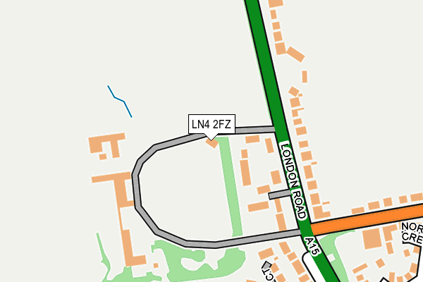
LN4 2FZ is located in the Bracebridge Heath electoral ward, within the local authority district of North Kesteven and the English Parliamentary constituency of Lincoln. The Sub Integrated Care Board (ICB) Location is NHS Lincolnshire ICB - 71E and the police force is Lincolnshire. This postcode has been in use since April 2017.


GetTheData
Source: OS OpenMap – Local (Ordnance Survey)
Source: OS VectorMap District (Ordnance Survey)
Licence: Open Government Licence (requires attribution)
| Easting | 497721 |
| Northing | 367949 |
| Latitude | 53.199671 |
| Longitude | -0.538573 |
GetTheData
Source: Open Postcode Geo
Licence: Open Government Licence
| Country | England |
| Postcode District | LN4 |
➜ See where LN4 is on a map ➜ Where is Bracebridge Heath? | |
GetTheData
Source: Land Registry Price Paid Data
Licence: Open Government Licence
| Ward | Bracebridge Heath |
| Constituency | Lincoln |
GetTheData
Source: ONS Postcode Database
Licence: Open Government Licence
| Canwick Avenue (London Road) | Bracebridge Heath | 142m |
| Canwick Avenue (London Road) | Bracebridge Heath | 171m |
| Caistor Drive (Canwick Avenue) | Bracebridge Heath | 307m |
| Caistor Drive (Canwick Avenue) | Bracebridge Heath | 310m |
| Coningsby Crescent (London Road) | Bracebridge Heath | 358m |
| Lincoln Central Station | 2.9km |
| Hykeham Station | 4.1km |
GetTheData
Source: NaPTAN
Licence: Open Government Licence
GetTheData
Source: ONS Postcode Database
Licence: Open Government Licence


➜ Get more ratings from the Food Standards Agency
GetTheData
Source: Food Standards Agency
Licence: FSA terms & conditions
| Last Collection | |||
|---|---|---|---|
| Location | Mon-Fri | Sat | Distance |
| Bramble Court | 17:15 | 12:30 | 167m |
| Litchfield | 17:30 | 11:15 | 647m |
| Parker Avenue | 17:30 | 12:30 | 890m |
GetTheData
Source: Dracos
Licence: Creative Commons Attribution-ShareAlike
The below table lists the International Territorial Level (ITL) codes (formerly Nomenclature of Territorial Units for Statistics (NUTS) codes) and Local Administrative Units (LAU) codes for LN4 2FZ:
| ITL 1 Code | Name |
|---|---|
| TLF | East Midlands (England) |
| ITL 2 Code | Name |
| TLF3 | Lincolnshire |
| ITL 3 Code | Name |
| TLF30 | Lincolnshire CC |
| LAU 1 Code | Name |
| E07000139 | North Kesteven |
GetTheData
Source: ONS Postcode Directory
Licence: Open Government Licence
The below table lists the Census Output Area (OA), Lower Layer Super Output Area (LSOA), and Middle Layer Super Output Area (MSOA) for LN4 2FZ:
| Code | Name | |
|---|---|---|
| OA | E00132965 | |
| LSOA | E01026186 | North Kesteven 001A |
| MSOA | E02005453 | North Kesteven 001 |
GetTheData
Source: ONS Postcode Directory
Licence: Open Government Licence
| LN4 2JP | Stanley Crescent | 60m |
| LN4 2JW | London Road | 170m |
| LN4 2JR | London Road | 183m |
| LN4 2JG | Perry Court | 218m |
| LN4 2JX | Churchill Avenue | 260m |
| LN4 2JU | The Link | 270m |
| LN4 2JS | Redhall Drive | 297m |
| LN4 2JT | Redhall Drive | 323m |
| LN4 2JY | Whitehall Crescent | 323m |
| LN4 2ST | Norfolk Crescent | 339m |
GetTheData
Source: Open Postcode Geo; Land Registry Price Paid Data
Licence: Open Government Licence