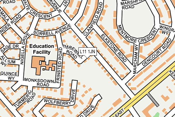
L11 1JN is located in the Norris Green electoral ward, within the metropolitan district of Liverpool and the English Parliamentary constituency of Liverpool, West Derby. The Sub Integrated Care Board (ICB) Location is NHS Cheshire and Merseyside ICB - 99A and the police force is Merseyside. This postcode has been in use since February 2017.


GetTheData
Source: OS OpenMap – Local (Ordnance Survey)
Source: OS VectorMap District (Ordnance Survey)
Licence: Open Government Licence (requires attribution)
| Easting | 339511 |
| Northing | 394264 |
| Latitude | 53.441676 |
| Longitude | -2.912106 |
GetTheData
Source: Open Postcode Geo
Licence: Open Government Licence
| Country | England |
| Postcode District | L11 |
➜ See where L11 is on a map ➜ Where is Liverpool? | |
GetTheData
Source: Land Registry Price Paid Data
Licence: Open Government Licence
| Ward | Norris Green |
| Constituency | Liverpool, West Derby |
GetTheData
Source: ONS Postcode Database
Licence: Open Government Licence
| Clanfield Road (Stalisfield Avenue) | Norris Green | 38m |
| Clanfield Road (Stalisfield Avenue) | Norris Green | 62m |
| Stalisfield Avenue (Muirhead Avenue East) | West Derby | 190m |
| Meadow Lane (Muirhead Avenue East) | West Derby | 226m |
| Wingrave Way (Muirhead Avenue East) | West Derby | 344m |
| Fazakerley Station | 3.5km |
| Rice Lane Station | 3.8km |
| Walton (Merseyside) Station | 3.9km |
GetTheData
Source: NaPTAN
Licence: Open Government Licence
| Percentage of properties with Next Generation Access | 100.0% |
| Percentage of properties with Superfast Broadband | 100.0% |
| Percentage of properties with Ultrafast Broadband | 100.0% |
| Percentage of properties with Full Fibre Broadband | 0.0% |
Superfast Broadband is between 30Mbps and 300Mbps
Ultrafast Broadband is > 300Mbps
| Percentage of properties unable to receive 2Mbps | 0.0% |
| Percentage of properties unable to receive 5Mbps | 0.0% |
| Percentage of properties unable to receive 10Mbps | 0.0% |
| Percentage of properties unable to receive 30Mbps | 0.0% |
GetTheData
Source: Ofcom
Licence: Ofcom Terms of Use (requires attribution)
GetTheData
Source: ONS Postcode Database
Licence: Open Government Licence


➜ Get more ratings from the Food Standards Agency
GetTheData
Source: Food Standards Agency
Licence: FSA terms & conditions
| Last Collection | |||
|---|---|---|---|
| Location | Mon-Fri | Sat | Distance |
| Town Row Delivery Office | 17:30 | 12:00 | 1,423m |
| Mill Bank | 17:15 | 12:00 | 1,831m |
| Eaton Road North | 16:15 | 12:00 | 2,061m |
GetTheData
Source: Dracos
Licence: Creative Commons Attribution-ShareAlike
The below table lists the International Territorial Level (ITL) codes (formerly Nomenclature of Territorial Units for Statistics (NUTS) codes) and Local Administrative Units (LAU) codes for L11 1JN:
| ITL 1 Code | Name |
|---|---|
| TLD | North West (England) |
| ITL 2 Code | Name |
| TLD7 | Merseyside |
| ITL 3 Code | Name |
| TLD72 | Liverpool |
| LAU 1 Code | Name |
| E08000012 | Liverpool |
GetTheData
Source: ONS Postcode Directory
Licence: Open Government Licence
The below table lists the Census Output Area (OA), Lower Layer Super Output Area (LSOA), and Middle Layer Super Output Area (MSOA) for L11 1JN:
| Code | Name | |
|---|---|---|
| OA | E00176767 | |
| LSOA | E01006599 | Liverpool 010B |
| MSOA | E02001356 | Liverpool 010 |
GetTheData
Source: ONS Postcode Directory
Licence: Open Government Licence
| L11 2UW | Stalisfield Avenue | 49m |
| L11 2TB | Elkstone Road | 81m |
| L11 2TD | Elkstone Road | 109m |
| L11 2AW | Sorrel Avenue | 168m |
| L11 2TA | Marcham Way | 184m |
| L11 1HH | Monksdown Road | 187m |
| L11 2TJ | Mentmore Crescent | 205m |
| L11 2TE | Clanfield Road | 207m |
| L11 2UY | Swallowhurst Crescent | 215m |
| L11 2UG | Dencourt Road | 222m |
GetTheData
Source: Open Postcode Geo; Land Registry Price Paid Data
Licence: Open Government Licence