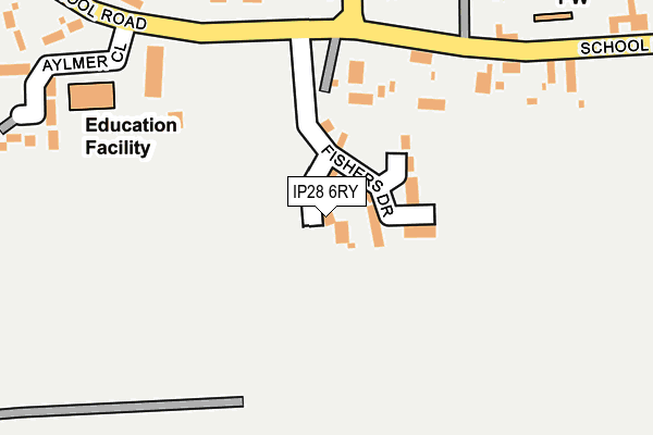
IP28 6RY is located in the Risby electoral ward, within the local authority district of West Suffolk and the English Parliamentary constituency of West Suffolk. The Sub Integrated Care Board (ICB) Location is NHS Suffolk and North East Essex ICB - 07K and the police force is Suffolk. This postcode has been in use since June 2017.


GetTheData
Source: OS OpenMap – Local (Ordnance Survey)
Source: OS VectorMap District (Ordnance Survey)
Licence: Open Government Licence (requires attribution)
| Easting | 580017 |
| Northing | 266188 |
| Latitude | 52.264403 |
| Longitude | 0.636554 |
GetTheData
Source: Open Postcode Geo
Licence: Open Government Licence
| Country | England |
| Postcode District | IP28 |
➜ See where IP28 is on a map | |
GetTheData
Source: Land Registry Price Paid Data
Licence: Open Government Licence
| Ward | Risby |
| Constituency | West Suffolk |
GetTheData
Source: ONS Postcode Database
Licence: Open Government Licence
| School (School Road) | Risby | 229m |
| School (School Road) | Risby | 231m |
| Church | Risby | 267m |
| Church | Risby | 269m |
| Green (School Road) | Risby | 419m |
GetTheData
Source: NaPTAN
Licence: Open Government Licence
| Percentage of properties with Next Generation Access | 100.0% |
| Percentage of properties with Superfast Broadband | 100.0% |
| Percentage of properties with Ultrafast Broadband | 0.0% |
| Percentage of properties with Full Fibre Broadband | 0.0% |
Superfast Broadband is between 30Mbps and 300Mbps
Ultrafast Broadband is > 300Mbps
| Percentage of properties unable to receive 2Mbps | 0.0% |
| Percentage of properties unable to receive 5Mbps | 0.0% |
| Percentage of properties unable to receive 10Mbps | 0.0% |
| Percentage of properties unable to receive 30Mbps | 0.0% |
GetTheData
Source: Ofcom
Licence: Ofcom Terms of Use (requires attribution)
GetTheData
Source: ONS Postcode Database
Licence: Open Government Licence


➜ Get more ratings from the Food Standards Agency
GetTheData
Source: Food Standards Agency
Licence: FSA terms & conditions
| Last Collection | |||
|---|---|---|---|
| Location | Mon-Fri | Sat | Distance |
| Post Office, South Street | 16:00 | 11:30 | 391m |
| Ip28 Woodland Cose | 16:00 | 10:00 | 703m |
| Old Rectory | 16:00 | 11:00 | 2,499m |
GetTheData
Source: Dracos
Licence: Creative Commons Attribution-ShareAlike
The below table lists the International Territorial Level (ITL) codes (formerly Nomenclature of Territorial Units for Statistics (NUTS) codes) and Local Administrative Units (LAU) codes for IP28 6RY:
| ITL 1 Code | Name |
|---|---|
| TLH | East |
| ITL 2 Code | Name |
| TLH1 | East Anglia |
| ITL 3 Code | Name |
| TLH14 | Suffolk CC |
| LAU 1 Code | Name |
| E07000245 | West Suffolk |
GetTheData
Source: ONS Postcode Directory
Licence: Open Government Licence
The below table lists the Census Output Area (OA), Lower Layer Super Output Area (LSOA), and Middle Layer Super Output Area (MSOA) for IP28 6RY:
| Code | Name | |
|---|---|---|
| OA | E00153630 | |
| LSOA | E01030134 | St Edmundsbury 008D |
| MSOA | E02006280 | St Edmundsbury 008 |
GetTheData
Source: ONS Postcode Directory
Licence: Open Government Licence
| IP28 6RP | Quays Barns | 131m |
| IP28 6RQ | School Road | 259m |
| IP28 6RT | Aylmer Close | 273m |
| IP28 6RG | School Road | 290m |
| IP28 6RS | Hall Lane | 312m |
| IP28 6QU | South Street | 355m |
| IP28 6US | Hanbury Paddocks | 382m |
| IP28 6RF | The Green | 400m |
| IP28 6QL | Orchard Close | 449m |
| IP28 6RL | Quays Road | 471m |
GetTheData
Source: Open Postcode Geo; Land Registry Price Paid Data
Licence: Open Government Licence