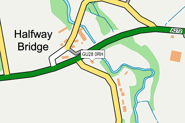
GU28 0RH is located in the Easebourne electoral ward, within the local authority district of Chichester and the English Parliamentary constituency of Chichester. The Sub Integrated Care Board (ICB) Location is NHS Sussex ICB - 70F and the police force is Sussex. This postcode has been in use since July 2017.


GetTheData
Source: OS OpenMap – Local (Ordnance Survey)
Source: OS VectorMap District (Ordnance Survey)
Licence: Open Government Licence (requires attribution)
| Easting | 493151 |
| Northing | 121900 |
| Latitude | 50.988968 |
| Longitude | -0.674170 |
GetTheData
Source: Open Postcode Geo
Licence: Open Government Licence
| Country | England |
| Postcode District | GU28 |
➜ See where GU28 is on a map ➜ Where is Halfway Bridge? | |
GetTheData
Source: Land Registry Price Paid Data
Licence: Open Government Licence
| Ward | Easebourne |
| Constituency | Chichester |
GetTheData
Source: ONS Postcode Database
Licence: Open Government Licence
| Halfway Bridge (A272) | Lodsworth | 160m |
| Halfway Bridge (A272) | Lodsworth | 193m |
| Langham Stables (Unnamed Road) | Lodsworth | 630m |
| Lods Bridge (Unnamed Road) | Selham | 633m |
| Langham Stables (Unnamed Road) | Lodsworth | 635m |
GetTheData
Source: NaPTAN
Licence: Open Government Licence
| Percentage of properties with Next Generation Access | 100.0% |
| Percentage of properties with Superfast Broadband | 0.0% |
| Percentage of properties with Ultrafast Broadband | 0.0% |
| Percentage of properties with Full Fibre Broadband | 0.0% |
Superfast Broadband is between 30Mbps and 300Mbps
Ultrafast Broadband is > 300Mbps
| Percentage of properties unable to receive 2Mbps | 0.0% |
| Percentage of properties unable to receive 5Mbps | 0.0% |
| Percentage of properties unable to receive 10Mbps | 0.0% |
| Percentage of properties unable to receive 30Mbps | 100.0% |
GetTheData
Source: Ofcom
Licence: Ofcom Terms of Use (requires attribution)
GetTheData
Source: ONS Postcode Database
Licence: Open Government Licence


➜ Get more ratings from the Food Standards Agency
GetTheData
Source: Food Standards Agency
Licence: FSA terms & conditions
| Last Collection | |||
|---|---|---|---|
| Location | Mon-Fri | Sat | Distance |
| Selham | 17:00 | 07:00 | 1,182m |
| Lodsworth | 16:15 | 10:00 | 1,193m |
| River Lane | 16:00 | 08:30 | 1,276m |
GetTheData
Source: Dracos
Licence: Creative Commons Attribution-ShareAlike
The below table lists the International Territorial Level (ITL) codes (formerly Nomenclature of Territorial Units for Statistics (NUTS) codes) and Local Administrative Units (LAU) codes for GU28 0RH:
| ITL 1 Code | Name |
|---|---|
| TLJ | South East (England) |
| ITL 2 Code | Name |
| TLJ2 | Surrey, East and West Sussex |
| ITL 3 Code | Name |
| TLJ27 | West Sussex (South West) |
| LAU 1 Code | Name |
| E07000225 | Chichester |
GetTheData
Source: ONS Postcode Directory
Licence: Open Government Licence
The below table lists the Census Output Area (OA), Lower Layer Super Output Area (LSOA), and Middle Layer Super Output Area (MSOA) for GU28 0RH:
| Code | Name | |
|---|---|---|
| OA | E00160635 | |
| LSOA | E01031498 | Chichester 005C |
| MSOA | E02006565 | Chichester 005 |
GetTheData
Source: ONS Postcode Directory
Licence: Open Government Licence
| GU28 9BP | Halfway Bridge | 81m |
| GU28 0PJ | 184m | |
| GU28 9DE | 842m | |
| GU28 9DB | 937m | |
| GU28 9DD | Church Lane | 950m |
| GU28 9DF | Vicarage Lane | 1016m |
| GU28 9DA | 1076m | |
| GU28 0PL | Barnfield Cottages | 1096m |
| GU28 0PG | 1120m | |
| GU28 9AX | 1228m |
GetTheData
Source: Open Postcode Geo; Land Registry Price Paid Data
Licence: Open Government Licence