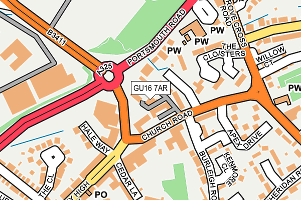
GU16 7AR is located in the Frimley electoral ward, within the local authority district of Surrey Heath and the English Parliamentary constituency of Surrey Heath. The Sub Integrated Care Board (ICB) Location is NHS Frimley ICB - D4U1Y and the police force is Surrey. This postcode has been in use since April 2017.


GetTheData
Source: OS OpenMap – Local (Ordnance Survey)
Source: OS VectorMap District (Ordnance Survey)
Licence: Open Government Licence (requires attribution)
| Easting | 487702 |
| Northing | 158070 |
| Latitude | 51.314991 |
| Longitude | -0.742986 |
GetTheData
Source: Open Postcode Geo
Licence: Open Government Licence
| Country | England |
| Postcode District | GU16 |
➜ See where GU16 is on a map ➜ Where is Frimley? | |
GetTheData
Source: Land Registry Price Paid Data
Licence: Open Government Licence
| Ward | Frimley |
| Constituency | Surrey Heath |
GetTheData
Source: ONS Postcode Database
Licence: Open Government Licence
| White Hart (High Street) | Frimley | 52m |
| Church Road | Frimley | 52m |
| Church Road | Frimley | 62m |
| High Street (Frimley High Street) | Frimley | 162m |
| Frimley Park (Portsmouth Road) | Frimley | 177m |
| Frimley Station | 0.4km |
| Farnborough North Station | 1.4km |
| Farnborough (Main) Station | 2.2km |
GetTheData
Source: NaPTAN
Licence: Open Government Licence
| Percentage of properties with Next Generation Access | 100.0% |
| Percentage of properties with Superfast Broadband | 100.0% |
| Percentage of properties with Ultrafast Broadband | 100.0% |
| Percentage of properties with Full Fibre Broadband | 0.0% |
Superfast Broadband is between 30Mbps and 300Mbps
Ultrafast Broadband is > 300Mbps
| Median download speed | 77.5Mbps |
| Average download speed | 90.7Mbps |
| Maximum download speed | 200.00Mbps |
| Median upload speed | 9.9Mbps |
| Average upload speed | 9.9Mbps |
| Maximum upload speed | 10.00Mbps |
| Percentage of properties unable to receive 2Mbps | 0.0% |
| Percentage of properties unable to receive 5Mbps | 0.0% |
| Percentage of properties unable to receive 10Mbps | 0.0% |
| Percentage of properties unable to receive 30Mbps | 0.0% |
GetTheData
Source: Ofcom
Licence: Ofcom Terms of Use (requires attribution)
GetTheData
Source: ONS Postcode Database
Licence: Open Government Licence


➜ Get more ratings from the Food Standards Agency
GetTheData
Source: Food Standards Agency
Licence: FSA terms & conditions
| Last Collection | |||
|---|---|---|---|
| Location | Mon-Fri | Sat | Distance |
| Cedar Lane | 17:15 | 12:15 | 137m |
| High Street | 17:15 | 12:15 | 165m |
| Frimley Post Office | 17:30 | 12:30 | 316m |
GetTheData
Source: Dracos
Licence: Creative Commons Attribution-ShareAlike
The below table lists the International Territorial Level (ITL) codes (formerly Nomenclature of Territorial Units for Statistics (NUTS) codes) and Local Administrative Units (LAU) codes for GU16 7AR:
| ITL 1 Code | Name |
|---|---|
| TLJ | South East (England) |
| ITL 2 Code | Name |
| TLJ2 | Surrey, East and West Sussex |
| ITL 3 Code | Name |
| TLJ25 | West Surrey |
| LAU 1 Code | Name |
| E07000214 | Surrey Heath |
GetTheData
Source: ONS Postcode Directory
Licence: Open Government Licence
The below table lists the Census Output Area (OA), Lower Layer Super Output Area (LSOA), and Middle Layer Super Output Area (MSOA) for GU16 7AR:
| Code | Name | |
|---|---|---|
| OA | E00156906 | |
| LSOA | E01030766 | Surrey Heath 010A |
| MSOA | E02006425 | Surrey Heath 010 |
GetTheData
Source: ONS Postcode Directory
Licence: Open Government Licence
| GU16 7HY | The Parade | 102m |
| GU16 7AB | Church Road | 105m |
| GU16 7AA | Portsmouth Road | 122m |
| GU16 7AE | Church Road | 124m |
| GU16 7JW | The Cloisters | 137m |
| GU16 7JR | The Cloisters | 145m |
| GU16 7HX | Hale Way | 152m |
| GU16 7HT | Cedar Lane | 187m |
| GU16 7JN | The Cloisters | 189m |
| GU16 7AF | Apex Drive | 197m |
GetTheData
Source: Open Postcode Geo; Land Registry Price Paid Data
Licence: Open Government Licence