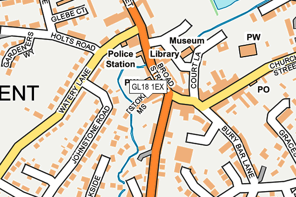
GL18 1EX is located in the Newent & Taynton electoral ward, within the local authority district of Forest of Dean and the English Parliamentary constituency of Forest of Dean. The Sub Integrated Care Board (ICB) Location is NHS Gloucestershire ICB - 11M and the police force is Gloucestershire. This postcode has been in use since June 2017.


GetTheData
Source: OS OpenMap – Local (Ordnance Survey)
Source: OS VectorMap District (Ordnance Survey)
Licence: Open Government Licence (requires attribution)
| Easting | 372891 |
| Northing | 226131 |
| Latitude | 51.933032 |
| Longitude | -2.395692 |
GetTheData
Source: Open Postcode Geo
Licence: Open Government Licence
| Country | England |
| Postcode District | GL18 |
➜ See where GL18 is on a map ➜ Where is Newent? | |
GetTheData
Source: Land Registry Price Paid Data
Licence: Open Government Licence
| Ward | Newent & Taynton |
| Constituency | Forest Of Dean |
GetTheData
Source: ONS Postcode Database
Licence: Open Government Licence
| Onslow Road (Gloucester Street) | Newent | 216m |
| Onslow Road (Gloucester Street) | Newent | 226m |
| Chedworth (Foley Road) | Newent | 393m |
| The Black Dog (Gloucester Street) | Newent | 431m |
| The Black Dog (Church Street) | Newent | 441m |
GetTheData
Source: NaPTAN
Licence: Open Government Licence
| Percentage of properties with Next Generation Access | 0.0% |
| Percentage of properties with Superfast Broadband | 0.0% |
| Percentage of properties with Ultrafast Broadband | 0.0% |
| Percentage of properties with Full Fibre Broadband | 0.0% |
Superfast Broadband is between 30Mbps and 300Mbps
Ultrafast Broadband is > 300Mbps
| Median download speed | 12.3Mbps |
| Average download speed | 16.4Mbps |
| Maximum download speed | 78.11Mbps |
| Median upload speed | 1.1Mbps |
| Average upload speed | 2.4Mbps |
| Maximum upload speed | 19.53Mbps |
| Percentage of properties unable to receive 2Mbps | 0.0% |
| Percentage of properties unable to receive 5Mbps | 0.0% |
| Percentage of properties unable to receive 10Mbps | 0.0% |
| Percentage of properties unable to receive 30Mbps | 100.0% |
GetTheData
Source: Ofcom
Licence: Ofcom Terms of Use (requires attribution)
GetTheData
Source: ONS Postcode Database
Licence: Open Government Licence


➜ Get more ratings from the Food Standards Agency
GetTheData
Source: Food Standards Agency
Licence: FSA terms & conditions
| Last Collection | |||
|---|---|---|---|
| Location | Mon-Fri | Sat | Distance |
| Onslow Road | 16:00 | 08:30 | 552m |
| Health Centre | 17:40 | 09:30 | 776m |
| Lakeside | 17:15 | 08:00 | 837m |
GetTheData
Source: Dracos
Licence: Creative Commons Attribution-ShareAlike
The below table lists the International Territorial Level (ITL) codes (formerly Nomenclature of Territorial Units for Statistics (NUTS) codes) and Local Administrative Units (LAU) codes for GL18 1EX:
| ITL 1 Code | Name |
|---|---|
| TLK | South West (England) |
| ITL 2 Code | Name |
| TLK1 | Gloucestershire, Wiltshire and Bath/Bristol area |
| ITL 3 Code | Name |
| TLK13 | Gloucestershire CC |
| LAU 1 Code | Name |
| E07000080 | Forest of Dean |
GetTheData
Source: ONS Postcode Directory
Licence: Open Government Licence
The below table lists the Census Output Area (OA), Lower Layer Super Output Area (LSOA), and Middle Layer Super Output Area (MSOA) for GL18 1EX:
| Code | Name | |
|---|---|---|
| OA | E00113195 | |
| LSOA | E01022267 | Forest of Dean 002C |
| MSOA | E02004627 | Forest of Dean 002 |
GetTheData
Source: ONS Postcode Directory
Licence: Open Government Licence
| GL18 1RQ | Croft Close | 105m |
| GL18 1EP | Cleeve Mill Business Park | 111m |
| GL18 1SW | Croft Road | 142m |
| GL18 1SL | Court Road | 179m |
| GL18 1BZ | Cleeve Rise | 203m |
| GL18 1SQ | The Crofts | 228m |
| GL18 1SN | Court Road | 267m |
| GL18 1SA | Onslow Road | 270m |
| GL18 1RY | Newlands Court | 279m |
| GL18 1AF | Gloucester Street | 291m |
GetTheData
Source: Open Postcode Geo; Land Registry Price Paid Data
Licence: Open Government Licence