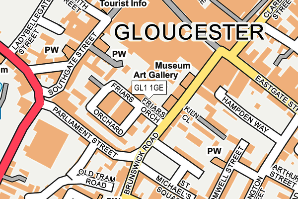
GL1 1GE is located in the Westgate electoral ward, within the local authority district of Gloucester and the English Parliamentary constituency of Gloucester. The Sub Integrated Care Board (ICB) Location is NHS Gloucestershire ICB - 11M and the police force is Gloucestershire. This postcode has been in use since July 2017.


GetTheData
Source: OS OpenMap – Local (Ordnance Survey)
Source: OS VectorMap District (Ordnance Survey)
Licence: Open Government Licence (requires attribution)
| Easting | 383150 |
| Northing | 218321 |
| Latitude | 51.863220 |
| Longitude | -2.246096 |
GetTheData
Source: Open Postcode Geo
Licence: Open Government Licence
| Country | England |
| Postcode District | GL1 |
➜ See where GL1 is on a map ➜ Where is Gloucester? | |
GetTheData
Source: Land Registry Price Paid Data
Licence: Open Government Licence
| Ward | Westgate |
| Constituency | Gloucester |
GetTheData
Source: ONS Postcode Database
Licence: Open Government Licence
| St Michael's Square (Brunswick Road) | Gloucester | 81m |
| St Michael's Square (Brunswick Road) | Gloucester | 88m |
| The Warehouse (Parliament Street) | Gloucester | 131m |
| New County Hotel (Southgate Street) | Gloucester | 143m |
| New County Hotel (Southgate Street) | Gloucester | 144m |
| Gloucester Station | 0.6km |
GetTheData
Source: NaPTAN
Licence: Open Government Licence
| Percentage of properties with Next Generation Access | 100.0% |
| Percentage of properties with Superfast Broadband | 100.0% |
| Percentage of properties with Ultrafast Broadband | 100.0% |
| Percentage of properties with Full Fibre Broadband | 0.0% |
Superfast Broadband is between 30Mbps and 300Mbps
Ultrafast Broadband is > 300Mbps
| Median download speed | 100.0Mbps |
| Average download speed | 90.1Mbps |
| Maximum download speed | 200.00Mbps |
| Median upload speed | 1.3Mbps |
| Average upload speed | 6.4Mbps |
| Maximum upload speed | 20.00Mbps |
| Percentage of properties unable to receive 2Mbps | 0.0% |
| Percentage of properties unable to receive 5Mbps | 0.0% |
| Percentage of properties unable to receive 10Mbps | 0.0% |
| Percentage of properties unable to receive 30Mbps | 0.0% |
GetTheData
Source: Ofcom
Licence: Ofcom Terms of Use (requires attribution)
GetTheData
Source: ONS Postcode Database
Licence: Open Government Licence


➜ Get more ratings from the Food Standards Agency
GetTheData
Source: Food Standards Agency
Licence: FSA terms & conditions
| Last Collection | |||
|---|---|---|---|
| Location | Mon-Fri | Sat | Distance |
| Southgate Street | 18:30 | 12:30 | 165m |
| Brunswick Rd Double#2 | 18:45 | 12:30 | 181m |
| Brunswick Road | 18:45 | 12:30 | 182m |
GetTheData
Source: Dracos
Licence: Creative Commons Attribution-ShareAlike
The below table lists the International Territorial Level (ITL) codes (formerly Nomenclature of Territorial Units for Statistics (NUTS) codes) and Local Administrative Units (LAU) codes for GL1 1GE:
| ITL 1 Code | Name |
|---|---|
| TLK | South West (England) |
| ITL 2 Code | Name |
| TLK1 | Gloucestershire, Wiltshire and Bath/Bristol area |
| ITL 3 Code | Name |
| TLK13 | Gloucestershire CC |
| LAU 1 Code | Name |
| E07000081 | Gloucester |
GetTheData
Source: ONS Postcode Directory
Licence: Open Government Licence
The below table lists the Census Output Area (OA), Lower Layer Super Output Area (LSOA), and Middle Layer Super Output Area (MSOA) for GL1 1GE:
| Code | Name | |
|---|---|---|
| OA | E00113600 | |
| LSOA | E01022347 | Gloucester 004B |
| MSOA | E02004639 | Gloucester 004 |
GetTheData
Source: ONS Postcode Directory
Licence: Open Government Licence
| GL1 1TT | Priory Place | 65m |
| GL1 1GA | Friars Orchard | 72m |
| GL1 1GB | Friars Orchard | 89m |
| GL1 1HG | Brunswick Road | 103m |
| GL1 1HP | Brunswick Road | 105m |
| GL1 1HY | Parliament Street | 110m |
| GL1 1TX | Southgate Street | 128m |
| GL1 1YQ | Parliament Street | 135m |
| GL1 1YG | Parliament Street | 137m |
| GL1 1GG | Kiln Close | 148m |
GetTheData
Source: Open Postcode Geo; Land Registry Price Paid Data
Licence: Open Government Licence