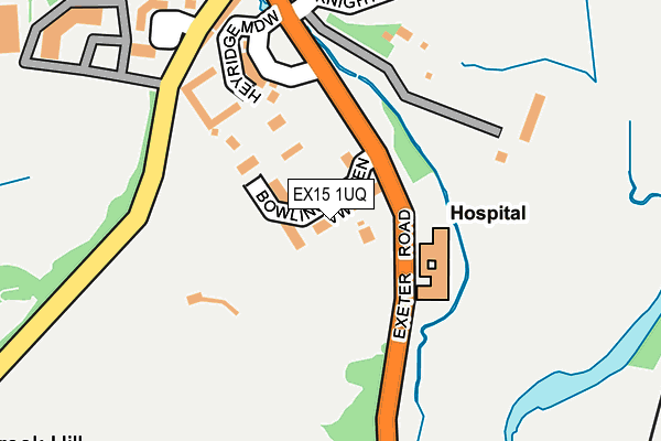
EX15 1UQ is located in the Cullompton Padbrook electoral ward, within the local authority district of Mid Devon and the English Parliamentary constituency of Tiverton and Honiton. The Sub Integrated Care Board (ICB) Location is NHS Devon ICB - 15N and the police force is Devon & Cornwall. This postcode has been in use since April 2017.


GetTheData
Source: OS OpenMap – Local (Ordnance Survey)
Source: OS VectorMap District (Ordnance Survey)
Licence: Open Government Licence (requires attribution)
| Easting | 301951 |
| Northing | 106218 |
| Latitude | 50.847137 |
| Longitude | -3.394112 |
GetTheData
Source: Open Postcode Geo
Licence: Open Government Licence
| Country | England |
| Postcode District | EX15 |
➜ See where EX15 is on a map ➜ Where is Cullompton? | |
GetTheData
Source: Land Registry Price Paid Data
Licence: Open Government Licence
| Ward | Cullompton Padbrook |
| Constituency | Tiverton And Honiton |
GetTheData
Source: ONS Postcode Database
Licence: Open Government Licence
12A, BOWLING GREEN VIEW, CULLOMPTON, EX15 1UQ 1999 1 OCT £175,000 |
GetTheData
Source: HM Land Registry Price Paid Data
Licence: Contains HM Land Registry data © Crown copyright and database right 2025. This data is licensed under the Open Government Licence v3.0.
| Swalcliffe House (B3181) | Cullompton | 105m |
| Heyridge Meadow (B3181) | Cullompton | 135m |
| Toad Hall (Exeter Road) | Cullompton | 283m |
| Swallow Way | Cullompton | 300m |
| Toad Hall (Exeter Road) | Cullompton | 308m |
GetTheData
Source: NaPTAN
Licence: Open Government Licence
| Percentage of properties with Next Generation Access | 100.0% |
| Percentage of properties with Superfast Broadband | 100.0% |
| Percentage of properties with Ultrafast Broadband | 0.0% |
| Percentage of properties with Full Fibre Broadband | 0.0% |
Superfast Broadband is between 30Mbps and 300Mbps
Ultrafast Broadband is > 300Mbps
| Median download speed | 39.0Mbps |
| Average download speed | 35.2Mbps |
| Maximum download speed | 70.12Mbps |
| Median upload speed | 9.8Mbps |
| Average upload speed | 8.6Mbps |
| Maximum upload speed | 20.00Mbps |
| Percentage of properties unable to receive 2Mbps | 0.0% |
| Percentage of properties unable to receive 5Mbps | 0.0% |
| Percentage of properties unable to receive 10Mbps | 0.0% |
| Percentage of properties unable to receive 30Mbps | 0.0% |
GetTheData
Source: Ofcom
Licence: Ofcom Terms of Use (requires attribution)
GetTheData
Source: ONS Postcode Database
Licence: Open Government Licence


➜ Get more ratings from the Food Standards Agency
GetTheData
Source: Food Standards Agency
Licence: FSA terms & conditions
| Last Collection | |||
|---|---|---|---|
| Location | Mon-Fri | Sat | Distance |
| Tesco | 17:45 | 12:00 | 1,380m |
| Motterton | 10:00 | 10:00 | 1,401m |
| St Georges Well | 17:45 | 12:00 | 1,820m |
GetTheData
Source: Dracos
Licence: Creative Commons Attribution-ShareAlike
The below table lists the International Territorial Level (ITL) codes (formerly Nomenclature of Territorial Units for Statistics (NUTS) codes) and Local Administrative Units (LAU) codes for EX15 1UQ:
| ITL 1 Code | Name |
|---|---|
| TLK | South West (England) |
| ITL 2 Code | Name |
| TLK4 | Devon |
| ITL 3 Code | Name |
| TLK43 | Devon CC |
| LAU 1 Code | Name |
| E07000042 | Mid Devon |
GetTheData
Source: ONS Postcode Directory
Licence: Open Government Licence
The below table lists the Census Output Area (OA), Lower Layer Super Output Area (LSOA), and Middle Layer Super Output Area (MSOA) for EX15 1UQ:
| Code | Name | |
|---|---|---|
| OA | E00101549 | |
| LSOA | E01020058 | Mid Devon 007D |
| MSOA | E02004170 | Mid Devon 007 |
GetTheData
Source: ONS Postcode Directory
Licence: Open Government Licence
| EX15 1FD | Heyridge Meadow | 163m |
| EX15 1EU | Knightswood | 255m |
| EX15 1ET | Knightswood | 270m |
| EX15 1EX | Knightswood | 316m |
| EX15 1RR | Wheatfield Close | 323m |
| EX15 1SH | Clover Drive | 360m |
| EX15 1TB | Ploudal Road | 367m |
| EX15 1TD | Heron Way | 373m |
| EX15 1QT | Dukes Mead | 389m |
| EX15 1RS | Barley Close | 398m |
GetTheData
Source: Open Postcode Geo; Land Registry Price Paid Data
Licence: Open Government Licence