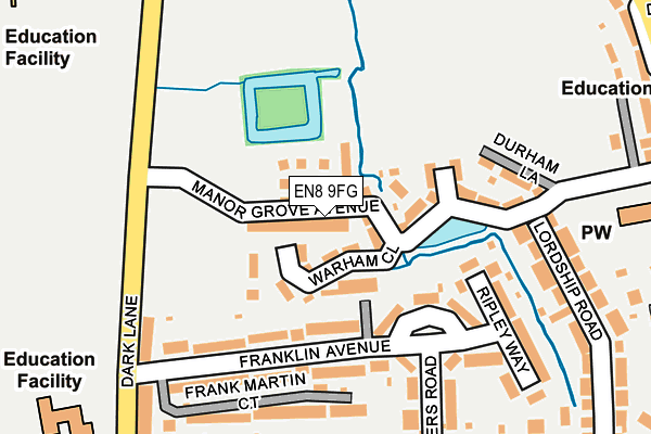
EN8 9FG is located in the Rosedale and Bury Green electoral ward, within the local authority district of Broxbourne and the English Parliamentary constituency of Broxbourne. The Sub Integrated Care Board (ICB) Location is NHS Hertfordshire and West Essex ICB - 06K and the police force is Hertfordshire. This postcode has been in use since April 2017.


GetTheData
Source: OS OpenMap – Local (Ordnance Survey)
Source: OS VectorMap District (Ordnance Survey)
Licence: Open Government Licence (requires attribution)
| Easting | 534658 |
| Northing | 202407 |
| Latitude | 51.704257 |
| Longitude | -0.052660 |
GetTheData
Source: Open Postcode Geo
Licence: Open Government Licence
| Country | England |
| Postcode District | EN8 |
➜ See where EN8 is on a map ➜ Where is Cheshunt? | |
GetTheData
Source: Land Registry Price Paid Data
Licence: Open Government Licence
| Ward | Rosedale And Bury Green |
| Constituency | Broxbourne |
GetTheData
Source: ONS Postcode Database
Licence: Open Government Licence
6, MANOR GROVE AVENUE, CHESHUNT, WALTHAM CROSS, EN8 9FG 2018 28 APR £565,000 |
30, MANOR GROVE AVENUE, CHESHUNT, WALTHAM CROSS, EN8 9FG 2017 1 DEC £560,000 |
32, MANOR GROVE AVENUE, CHESHUNT, WALTHAM CROSS, EN8 9FG 2017 9 NOV £490,000 |
34, MANOR GROVE AVENUE, CHESHUNT, WALTHAM CROSS, EN8 9FG 2017 3 NOV £495,000 |
28, MANOR GROVE AVENUE, CHESHUNT, WALTHAM CROSS, EN8 9FG 2017 2 NOV £485,000 |
16, MANOR GROVE AVENUE, CHESHUNT, WALTHAM CROSS, EN8 9FG 2017 14 AUG £580,000 |
26, MANOR GROVE AVENUE, CHESHUNT, WALTHAM CROSS, EN8 9FG 2017 30 JUN £595,000 |
12, MANOR GROVE AVENUE, CHESHUNT, WALTHAM CROSS, EN8 9FG 2017 28 JUN £555,000 |
1, MANOR GROVE AVENUE, CHESHUNT, WALTHAM CROSS, EN8 9FG 2017 28 JUN £485,000 |
4, MANOR GROVE AVENUE, CHESHUNT, WALTHAM CROSS, EN8 9FG 2017 26 JUN £599,000 |
GetTheData
Source: HM Land Registry Price Paid Data
Licence: Contains HM Land Registry data © Crown copyright and database right 2025. This data is licensed under the Open Government Licence v3.0.
| Bonneygrove School (Dark Lane) | Bury Green | 256m |
| Dark Lane (Goff's Lane) | Cheshunt | 294m |
| Dark Lane (Goff's Lane) | Cheshunt | 301m |
| Dewhurst Road (Churchgate) | Cheshunt | 324m |
| Dewhurst Road (Churchgate) | Cheshunt | 340m |
| Theobalds Grove Station | 1.8km |
| Cheshunt Station | 2km |
| Waltham Cross Station | 2.8km |
GetTheData
Source: NaPTAN
Licence: Open Government Licence
| Percentage of properties with Next Generation Access | 100.0% |
| Percentage of properties with Superfast Broadband | 100.0% |
| Percentage of properties with Ultrafast Broadband | 100.0% |
| Percentage of properties with Full Fibre Broadband | 0.0% |
Superfast Broadband is between 30Mbps and 300Mbps
Ultrafast Broadband is > 300Mbps
| Median download speed | 100.0Mbps |
| Average download speed | 126.6Mbps |
| Maximum download speed | 350.00Mbps |
| Median upload speed | 10.0Mbps |
| Average upload speed | 12.4Mbps |
| Maximum upload speed | 19.43Mbps |
| Percentage of properties unable to receive 2Mbps | 0.0% |
| Percentage of properties unable to receive 5Mbps | 0.0% |
| Percentage of properties unable to receive 10Mbps | 0.0% |
| Percentage of properties unable to receive 30Mbps | 0.0% |
GetTheData
Source: Ofcom
Licence: Ofcom Terms of Use (requires attribution)
GetTheData
Source: ONS Postcode Database
Licence: Open Government Licence


➜ Get more ratings from the Food Standards Agency
GetTheData
Source: Food Standards Agency
Licence: FSA terms & conditions
| Last Collection | |||
|---|---|---|---|
| Location | Mon-Fri | Sat | Distance |
| Churchgate | 17:30 | 11:30 | 301m |
| Council Offices Churchgate | 18:15 | 11:30 | 330m |
| Goffs Lane | 17:00 | 11:30 | 358m |
GetTheData
Source: Dracos
Licence: Creative Commons Attribution-ShareAlike
The below table lists the International Territorial Level (ITL) codes (formerly Nomenclature of Territorial Units for Statistics (NUTS) codes) and Local Administrative Units (LAU) codes for EN8 9FG:
| ITL 1 Code | Name |
|---|---|
| TLH | East |
| ITL 2 Code | Name |
| TLH2 | Bedfordshire and Hertfordshire |
| ITL 3 Code | Name |
| TLH23 | Hertfordshire CC |
| LAU 1 Code | Name |
| E07000095 | Broxbourne |
GetTheData
Source: ONS Postcode Directory
Licence: Open Government Licence
The below table lists the Census Output Area (OA), Lower Layer Super Output Area (LSOA), and Middle Layer Super Output Area (MSOA) for EN8 9FG:
| Code | Name | |
|---|---|---|
| OA | E00118355 | |
| LSOA | E01023296 | Broxbourne 011D |
| MSOA | E02004853 | Broxbourne 011 |
GetTheData
Source: ONS Postcode Directory
Licence: Open Government Licence
| EN7 5DX | Franklin Avenue | 116m |
| EN7 5DZ | Franklin Avenue | 142m |
| EN7 5EA | Franklin Avenue | 166m |
| EN7 5DU | Ripley Way | 171m |
| EN7 5DY | Bakers Road | 183m |
| EN7 5DR | Lordship Road | 193m |
| EN7 5DP | Lordship Road | 226m |
| EN7 5DW | Cromwell Avenue | 239m |
| EN7 5DN | Cromwell Avenue | 257m |
| EN7 5EB | Dark Lane | 260m |
GetTheData
Source: Open Postcode Geo; Land Registry Price Paid Data
Licence: Open Government Licence