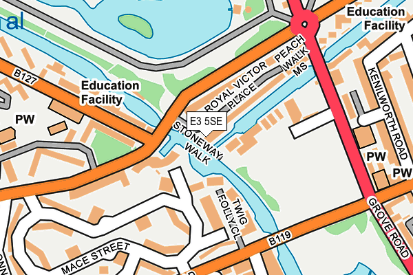
E3 5SE is located in the Bow West electoral ward, within the London borough of Tower Hamlets and the English Parliamentary constituency of Bethnal Green and Bow. The Sub Integrated Care Board (ICB) Location is NHS North East London ICB - A3A8R and the police force is Metropolitan Police. This postcode has been in use since July 2017.


GetTheData
Source: OS OpenMap – Local (Ordnance Survey)
Source: OS VectorMap District (Ordnance Survey)
Licence: Open Government Licence (requires attribution)
| Easting | 535800 |
| Northing | 183236 |
| Latitude | 51.531709 |
| Longitude | -0.043566 |
GetTheData
Source: Open Postcode Geo
Licence: Open Government Licence
| Country | England |
| Postcode District | E3 |
➜ See where E3 is on a map ➜ Where is Hackney? | |
GetTheData
Source: Land Registry Price Paid Data
Licence: Open Government Licence
| Ward | Bow West |
| Constituency | Bethnal Green And Bow |
GetTheData
Source: ONS Postcode Database
Licence: Open Government Licence
| Old Ford Road Grove Road (Grove Road) | Globe Town | 182m |
| Haverfield Green Grove Road (Roman Road) | Globe Town | 207m |
| Smart Street | Globe Town | 211m |
| Roman Road (Grove Road) | Globe Town | 218m |
| Victoria Park (Grove Road) | Globe Town | 256m |
| Bethnal Green Underground Station | Bethnal Green | 966m |
| Mile End Underground Station | Mile End | 1,007m |
| Stepney Green Underground Station | Stepney Green | 1,115m |
| Bow Road Underground Station | Bow | 1,387m |
| Whitechapel Underground Station | Whitechapel | 1,769m |
| Cambridge Heath (London) Station | 1km |
| Bethnal Green Station | 1.4km |
| London Fields Station | 1.4km |
GetTheData
Source: NaPTAN
Licence: Open Government Licence
| Percentage of properties with Next Generation Access | 100.0% |
| Percentage of properties with Superfast Broadband | 100.0% |
| Percentage of properties with Ultrafast Broadband | 0.0% |
| Percentage of properties with Full Fibre Broadband | 0.0% |
Superfast Broadband is between 30Mbps and 300Mbps
Ultrafast Broadband is > 300Mbps
| Percentage of properties unable to receive 2Mbps | 0.0% |
| Percentage of properties unable to receive 5Mbps | 0.0% |
| Percentage of properties unable to receive 10Mbps | 0.0% |
| Percentage of properties unable to receive 30Mbps | 0.0% |
GetTheData
Source: Ofcom
Licence: Ofcom Terms of Use (requires attribution)
GetTheData
Source: ONS Postcode Database
Licence: Open Government Licence


➜ Get more ratings from the Food Standards Agency
GetTheData
Source: Food Standards Agency
Licence: FSA terms & conditions
| Last Collection | |||
|---|---|---|---|
| Location | Mon-Fri | Sat | Distance |
| St James's Avenue | 18:30 | 11:30 | 303m |
| 359 Roman Road E3 | 17:30 | 12:00 | 345m |
| Gore Road | 17:00 | 11:30 | 573m |
GetTheData
Source: Dracos
Licence: Creative Commons Attribution-ShareAlike
The below table lists the International Territorial Level (ITL) codes (formerly Nomenclature of Territorial Units for Statistics (NUTS) codes) and Local Administrative Units (LAU) codes for E3 5SE:
| ITL 1 Code | Name |
|---|---|
| TLI | London |
| ITL 2 Code | Name |
| TLI4 | Inner London - East |
| ITL 3 Code | Name |
| TLI42 | Tower Hamlets |
| LAU 1 Code | Name |
| E09000030 | Tower Hamlets |
GetTheData
Source: ONS Postcode Directory
Licence: Open Government Licence
The below table lists the Census Output Area (OA), Lower Layer Super Output Area (LSOA), and Middle Layer Super Output Area (MSOA) for E3 5SE:
| Code | Name | |
|---|---|---|
| OA | E00021296 | |
| LSOA | E01004234 | Tower Hamlets 003E |
| MSOA | E02000866 | Tower Hamlets 003 |
GetTheData
Source: ONS Postcode Directory
Licence: Open Government Licence
| E2 0SW | Cranbrook Street | 69m |
| E2 9PR | Old Ford Road | 87m |
| E2 0SU | Twig Folly Close | 90m |
| E3 5SS | Royal Victor Place | 90m |
| E3 5SA | Old Ford Road | 91m |
| E2 9PY | Mace Street | 92m |
| E2 0PW | Gathorne Street | 106m |
| E2 0SS | Mace Street | 118m |
| E3 5SX | Old Ford Road | 125m |
| E2 9PT | Old Ford Road | 145m |
GetTheData
Source: Open Postcode Geo; Land Registry Price Paid Data
Licence: Open Government Licence