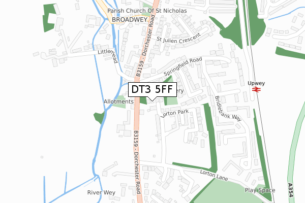
DT3 5FF maps, stats, and open data
DT3 5FF is located in the Upwey & Broadwey electoral ward, within the unitary authority of Dorset and the English Parliamentary constituency of South Dorset. The Sub Integrated Care Board (ICB) Location is NHS Dorset ICB - 11J and the police force is Dorset. This postcode has been in use since December 2017.
DT3 5FF maps


Licence: Open Government Licence (requires attribution)
Attribution: Contains OS data © Crown copyright and database right 2025
Source: Open Postcode Geo
Licence: Open Government Licence (requires attribution)
Attribution: Contains OS data © Crown copyright and database right 2025; Contains Royal Mail data © Royal Mail copyright and database right 2025; Source: Office for National Statistics licensed under the Open Government Licence v.3.0
DT3 5FF geodata
| Easting | 366807 |
| Northing | 83241 |
| Latitude | 50.647890 |
| Longitude | -2.470842 |
Where is DT3 5FF?
| Country | England |
| Postcode District | DT3 |
Politics
| Ward | Upwey & Broadwey |
|---|---|
| Constituency | South Dorset |
House Prices
Sales of detached houses in DT3 5FF
6, LORTON ORCHARD, WEYMOUTH, DT3 5FF 2018 30 JUL £485,000 |
4, LORTON ORCHARD, WEYMOUTH, DT3 5FF 2018 27 JUL £485,000 |
3, LORTON ORCHARD, WEYMOUTH, DT3 5FF 2018 9 FEB £485,000 |
5, LORTON ORCHARD, WEYMOUTH, DT3 5FF 2018 30 JAN £495,000 |
Licence: Contains HM Land Registry data © Crown copyright and database right 2025. This data is licensed under the Open Government Licence v3.0.
Transport
Nearest bus stops to DT3 5FF
| Springfield Road | Broadwey | 66m |
| Springfield Road | Broadwey | 76m |
| Methodist Church | Broadwey | 104m |
| Methodist Church (Dorchester Road) | Broadwey | 167m |
| Blackberry Lane (Blackbury Lane) | Redlands | 380m |
Nearest railway stations to DT3 5FF
| Upwey Station | 0.3km |
| Weymouth Station | 3.8km |
Broadband
Broadband access in DT3 5FF (2020 data)
| Percentage of properties with Next Generation Access | 100.0% |
| Percentage of properties with Superfast Broadband | 100.0% |
| Percentage of properties with Ultrafast Broadband | 100.0% |
| Percentage of properties with Full Fibre Broadband | 100.0% |
Superfast Broadband is between 30Mbps and 300Mbps
Ultrafast Broadband is > 300Mbps
Broadband limitations in DT3 5FF (2020 data)
| Percentage of properties unable to receive 2Mbps | 0.0% |
| Percentage of properties unable to receive 5Mbps | 0.0% |
| Percentage of properties unable to receive 10Mbps | 0.0% |
| Percentage of properties unable to receive 30Mbps | 0.0% |
Deprivation
67.5% of English postcodes are less deprived than DT3 5FF:Food Standards Agency
Three nearest food hygiene ratings to DT3 5FF (metres)


➜ Get more ratings from the Food Standards Agency
Nearest post box to DT3 5FF
| Last Collection | |||
|---|---|---|---|
| Location | Mon-Fri | Sat | Distance |
| Safeways | 17:00 | 12:00 | 1,660m |
| Buddleia Close | 17:00 | 09:00 | 1,914m |
| Bowleaze | 16:45 | 08:00 | 2,111m |
DT3 5FF ITL and DT3 5FF LAU
The below table lists the International Territorial Level (ITL) codes (formerly Nomenclature of Territorial Units for Statistics (NUTS) codes) and Local Administrative Units (LAU) codes for DT3 5FF:
| ITL 1 Code | Name |
|---|---|
| TLK | South West (England) |
| ITL 2 Code | Name |
| TLK2 | Dorset and Somerset |
| ITL 3 Code | Name |
| TLK25 | Dorset |
| LAU 1 Code | Name |
| E06000059 | Dorset |
DT3 5FF census areas
The below table lists the Census Output Area (OA), Lower Layer Super Output Area (LSOA), and Middle Layer Super Output Area (MSOA) for DT3 5FF:
| Code | Name | |
|---|---|---|
| OA | E00104337 | |
| LSOA | E01020571 | Weymouth and Portland 001D |
| MSOA | E02004281 | Weymouth and Portland 001 |
Nearest postcodes to DT3 5FF
| DT3 5BU | Dorchester Road | 48m |
| DT3 5BT | Dorchester Road | 70m |
| DT3 5BY | Dorchester Road | 118m |
| DT3 5DX | Springfield Road | 127m |
| DT3 5DE | Riverbank Cottages | 132m |
| DT3 5DY | Springfield Crescent | 141m |
| DT3 5BX | Dorchester Road | 159m |
| DT3 5DS | Merlin Avenue South | 164m |
| DT3 5RA | Bridlebank Way | 223m |
| DT3 5EA | The Orchard | 231m |