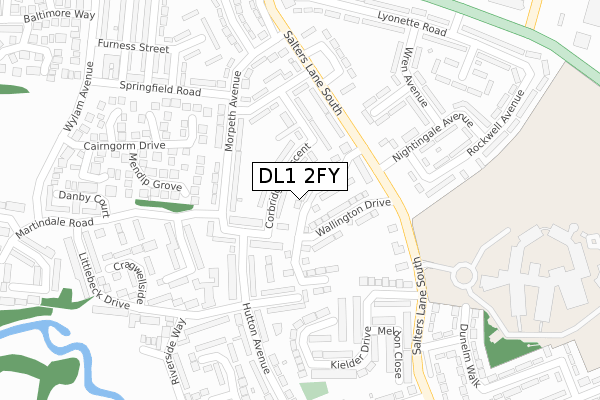
DL1 2FY is located in the Haughton & Springfield electoral ward, within the unitary authority of Darlington and the English Parliamentary constituency of Darlington. The Sub Integrated Care Board (ICB) Location is NHS North East and North Cumbria ICB - 16C and the police force is Durham. This postcode has been in use since April 2020.


GetTheData
Source: OS Open Zoomstack (Ordnance Survey)
Licence: Open Government Licence (requires attribution)
Attribution: Contains OS data © Crown copyright and database right 2025
Source: Open Postcode Geo
Licence: Open Government Licence (requires attribution)
Attribution: Contains OS data © Crown copyright and database right 2025; Contains Royal Mail data © Royal Mail copyright and database right 2025; Source: Office for National Statistics licensed under the Open Government Licence v.3.0
| Easting | 430427 |
| Northing | 516435 |
| Latitude | 54.542279 |
| Longitude | -1.531217 |
GetTheData
Source: Open Postcode Geo
Licence: Open Government Licence
| Country | England |
| Postcode District | DL1 |
➜ See where DL1 is on a map ➜ Where is Darlington? | |
GetTheData
Source: Land Registry Price Paid Data
Licence: Open Government Licence
| Ward | Haughton & Springfield |
| Constituency | Darlington |
GetTheData
Source: ONS Postcode Database
Licence: Open Government Licence
| Alnwick Place | Springfield | 134m |
| Nightingale Avenue (Salters Lane South) | Springfield | 135m |
| Alnwick Place | Springfield | 140m |
| Morpeth Avenue | Springfield | 148m |
| Morpeth Avenue (Martindale Road) | Springfield | 162m |
| North Road Station | 1.6km |
| Darlington Station | 2.6km |
| Dinsdale Station | 5.2km |
GetTheData
Source: NaPTAN
Licence: Open Government Licence
GetTheData
Source: ONS Postcode Database
Licence: Open Government Licence


➜ Get more ratings from the Food Standards Agency
GetTheData
Source: Food Standards Agency
Licence: FSA terms & conditions
| Last Collection | |||
|---|---|---|---|
| Location | Mon-Fri | Sat | Distance |
| Littlebeck Drive | 17:30 | 11:00 | 247m |
| Nightingale Avenue | 17:30 | 11:00 | 255m |
| Springfield | 17:30 | 11:30 | 344m |
GetTheData
Source: Dracos
Licence: Creative Commons Attribution-ShareAlike
The below table lists the International Territorial Level (ITL) codes (formerly Nomenclature of Territorial Units for Statistics (NUTS) codes) and Local Administrative Units (LAU) codes for DL1 2FY:
| ITL 1 Code | Name |
|---|---|
| TLC | North East (England) |
| ITL 2 Code | Name |
| TLC1 | Tees Valley and Durham |
| ITL 3 Code | Name |
| TLC13 | Darlington |
| LAU 1 Code | Name |
| E06000005 | Darlington |
GetTheData
Source: ONS Postcode Directory
Licence: Open Government Licence
The below table lists the Census Output Area (OA), Lower Layer Super Output Area (LSOA), and Middle Layer Super Output Area (MSOA) for DL1 2FY:
| Code | Name | |
|---|---|---|
| OA | E00062192 | |
| LSOA | E01012333 | Darlington 005D |
| MSOA | E02002563 | Darlington 005 |
GetTheData
Source: ONS Postcode Directory
Licence: Open Government Licence
| DL1 2QH | Corbridge Crescent | 32m |
| DL1 2QQ | Alnwick Place | 100m |
| DL1 2QL | Belsay Walk | 124m |
| DL1 2QG | Morpeth Avenue | 126m |
| DL1 2QJ | Belsay Walk | 127m |
| DL1 2AW | Salters Lane South | 156m |
| DL1 2AJ | Bamburgh Place | 186m |
| DL1 2QN | Belford Gardens | 191m |
| DL1 2BA | Daryngton Close | 194m |
| DL1 2BD | Kielder Drive | 218m |
GetTheData
Source: Open Postcode Geo; Land Registry Price Paid Data
Licence: Open Government Licence