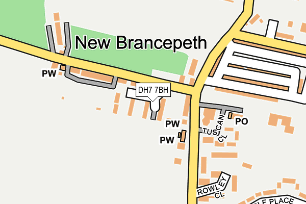
DH7 7BH is located in the Deerness electoral ward, within the unitary authority of County Durham and the English Parliamentary constituency of City of Durham. The Sub Integrated Care Board (ICB) Location is NHS North East and North Cumbria ICB - 84H and the police force is Durham. This postcode has been in use since March 2017.


GetTheData
Source: OS OpenMap – Local (Ordnance Survey)
Source: OS VectorMap District (Ordnance Survey)
Licence: Open Government Licence (requires attribution)
| Easting | 422318 |
| Northing | 541549 |
| Latitude | 54.768385 |
| Longitude | -1.654649 |
GetTheData
Source: Open Postcode Geo
Licence: Open Government Licence
| Country | England |
| Postcode District | DH7 |
➜ See where DH7 is on a map ➜ Where is New Brancepeth? | |
GetTheData
Source: Land Registry Price Paid Data
Licence: Open Government Licence
| Ward | Deerness |
| Constituency | City Of Durham |
GetTheData
Source: ONS Postcode Database
Licence: Open Government Licence
| Club (Street Not Known) | New Brancepeth | 116m |
| Club (Street Not Known) | New Brancepeth | 130m |
| Waltons Terrace | New Brancepeth | 293m |
| Pringle Place Allotments (Street Not Known) | New Brancepeth | 314m |
| Pringle Place Allotments (Street Not Known) | New Brancepeth | 327m |
| Durham Station | 4.8km |
GetTheData
Source: NaPTAN
Licence: Open Government Licence
| Percentage of properties with Next Generation Access | 100.0% |
| Percentage of properties with Superfast Broadband | 100.0% |
| Percentage of properties with Ultrafast Broadband | 0.0% |
| Percentage of properties with Full Fibre Broadband | 0.0% |
Superfast Broadband is between 30Mbps and 300Mbps
Ultrafast Broadband is > 300Mbps
| Median download speed | 63.0Mbps |
| Average download speed | 52.0Mbps |
| Maximum download speed | 80.00Mbps |
| Median upload speed | 17.6Mbps |
| Average upload speed | 13.3Mbps |
| Maximum upload speed | 20.00Mbps |
| Percentage of properties unable to receive 2Mbps | 0.0% |
| Percentage of properties unable to receive 5Mbps | 0.0% |
| Percentage of properties unable to receive 10Mbps | 0.0% |
| Percentage of properties unable to receive 30Mbps | 0.0% |
GetTheData
Source: Ofcom
Licence: Ofcom Terms of Use (requires attribution)
GetTheData
Source: ONS Postcode Database
Licence: Open Government Licence


➜ Get more ratings from the Food Standards Agency
GetTheData
Source: Food Standards Agency
Licence: FSA terms & conditions
| Last Collection | |||
|---|---|---|---|
| Location | Mon-Fri | Sat | Distance |
| Station Road, Ushaw Moor | 16:50 | 09:00 | 1,163m |
| Temperence Terrace | 17:30 | 12:00 | 1,248m |
| Oakridge Road, Ushaw Moor | 16:00 | 09:15 | 1,425m |
GetTheData
Source: Dracos
Licence: Creative Commons Attribution-ShareAlike
The below table lists the International Territorial Level (ITL) codes (formerly Nomenclature of Territorial Units for Statistics (NUTS) codes) and Local Administrative Units (LAU) codes for DH7 7BH:
| ITL 1 Code | Name |
|---|---|
| TLC | North East (England) |
| ITL 2 Code | Name |
| TLC1 | Tees Valley and Durham |
| ITL 3 Code | Name |
| TLC14 | Durham |
| LAU 1 Code | Name |
| E06000047 | County Durham |
GetTheData
Source: ONS Postcode Directory
Licence: Open Government Licence
The below table lists the Census Output Area (OA), Lower Layer Super Output Area (LSOA), and Middle Layer Super Output Area (MSOA) for DH7 7BH:
| Code | Name | |
|---|---|---|
| OA | E00105114 | |
| LSOA | E01020715 | County Durham 031C |
| MSOA | E02004316 | County Durham 031 |
GetTheData
Source: ONS Postcode Directory
Licence: Open Government Licence
| DH7 7HB | Fairfalls Terrace | 100m |
| DH7 7HT | Bewley Terrace | 135m |
| DH7 7HP | 151m | |
| DH7 7HZ | 151m | |
| DH7 7HD | Prospect Place | 163m |
| DH7 7HU | Hawthorne Terrace | 166m |
| DH7 7HX | Benville Terrace | 192m |
| DH7 7HE | Woodbine Terrace | 195m |
| DH7 7JT | Tuscan Close | 205m |
| DH7 7JR | Rowley Close | 222m |
GetTheData
Source: Open Postcode Geo; Land Registry Price Paid Data
Licence: Open Government Licence