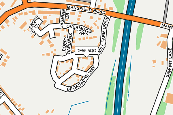
DE55 5QQ is located in the Tibshelf electoral ward, within the local authority district of Bolsover and the English Parliamentary constituency of Bolsover. The Sub Integrated Care Board (ICB) Location is NHS Derby and Derbyshire ICB - 15M and the police force is Derbyshire. This postcode has been in use since February 2017.


GetTheData
Source: OS OpenMap – Local (Ordnance Survey)
Source: OS VectorMap District (Ordnance Survey)
Licence: Open Government Licence (requires attribution)
| Easting | 444603 |
| Northing | 361043 |
| Latitude | 53.144692 |
| Longitude | -1.334616 |
GetTheData
Source: Open Postcode Geo
Licence: Open Government Licence
| Country | England |
| Postcode District | DE55 |
➜ See where DE55 is on a map ➜ Where is Tibshelf? | |
GetTheData
Source: Land Registry Price Paid Data
Licence: Open Government Licence
| Ward | Tibshelf |
| Constituency | Bolsover |
GetTheData
Source: ONS Postcode Database
Licence: Open Government Licence
8, MILL FARM DRIVE, TIBSHELF, ALFRETON, DE55 5QQ 2024 22 MAR £277,500 |
8, MILL FARM DRIVE, TIBSHELF, ALFRETON, DE55 5QQ 2023 8 DEC £279,995 |
2023 30 AUG £285,000 |
50, MILL FARM DRIVE, TIBSHELF, ALFRETON, DE55 5QQ 2020 31 JUL £196,000 |
58, MILL FARM DRIVE, TIBSHELF, ALFRETON, DE55 5QQ 2020 30 JUN £192,950 |
40, MILL FARM DRIVE, TIBSHELF, ALFRETON, DE55 5QQ 2019 7 OCT £232,950 |
34, MILL FARM DRIVE, TIBSHELF, ALFRETON, DE55 5QQ 2019 27 SEP £231,950 |
24, MILL FARM DRIVE, TIBSHELF, ALFRETON, DE55 5QQ 2018 31 OCT £186,000 |
2017 30 NOV £229,950 |
8, MILL FARM DRIVE, TIBSHELF, ALFRETON, DE55 5QQ 2017 29 SEP £229,950 |
GetTheData
Source: HM Land Registry Price Paid Data
Licence: Contains HM Land Registry data © Crown copyright and database right 2025. This data is licensed under the Open Government Licence v3.0.
| Waverley Street (High Street) | Tibshelf | 270m |
| Waverley Street (High Street) | Tibshelf | 280m |
| White Hart Inn (High Street) | Tibshelf | 286m |
| White Hart Inn (Mansfield Road) | Tibshelf | 292m |
| Jasmine Drive (Mansfield Road) | Tibshelf | 298m |
| Alfreton Station | 5.5km |
GetTheData
Source: NaPTAN
Licence: Open Government Licence
| Percentage of properties with Next Generation Access | 100.0% |
| Percentage of properties with Superfast Broadband | 100.0% |
| Percentage of properties with Ultrafast Broadband | 100.0% |
| Percentage of properties with Full Fibre Broadband | 0.0% |
Superfast Broadband is between 30Mbps and 300Mbps
Ultrafast Broadband is > 300Mbps
| Median download speed | 100.0Mbps |
| Average download speed | 72.6Mbps |
| Maximum download speed | 200.00Mbps |
| Median upload speed | 1.1Mbps |
| Average upload speed | 1.0Mbps |
| Maximum upload speed | 1.14Mbps |
| Percentage of properties unable to receive 2Mbps | 0.0% |
| Percentage of properties unable to receive 5Mbps | 0.0% |
| Percentage of properties unable to receive 10Mbps | 0.0% |
| Percentage of properties unable to receive 30Mbps | 0.0% |
GetTheData
Source: Ofcom
Licence: Ofcom Terms of Use (requires attribution)
GetTheData
Source: ONS Postcode Database
Licence: Open Government Licence


➜ Get more ratings from the Food Standards Agency
GetTheData
Source: Food Standards Agency
Licence: FSA terms & conditions
| Last Collection | |||
|---|---|---|---|
| Location | Mon-Fri | Sat | Distance |
| White Hart | 16:00 | 08:00 | 294m |
| Tibshelf Post Office | 16:30 | 08:00 | 380m |
| Classic Journeys Box | 16:30 | 08:00 | 854m |
GetTheData
Source: Dracos
Licence: Creative Commons Attribution-ShareAlike
The below table lists the International Territorial Level (ITL) codes (formerly Nomenclature of Territorial Units for Statistics (NUTS) codes) and Local Administrative Units (LAU) codes for DE55 5QQ:
| ITL 1 Code | Name |
|---|---|
| TLF | East Midlands (England) |
| ITL 2 Code | Name |
| TLF1 | Derbyshire and Nottinghamshire |
| ITL 3 Code | Name |
| TLF12 | East Derbyshire |
| LAU 1 Code | Name |
| E07000033 | Bolsover |
GetTheData
Source: ONS Postcode Directory
Licence: Open Government Licence
The below table lists the Census Output Area (OA), Lower Layer Super Output Area (LSOA), and Middle Layer Super Output Area (MSOA) for DE55 5QQ:
| Code | Name | |
|---|---|---|
| OA | E00098735 | |
| LSOA | E01019521 | Bolsover 008D |
| MSOA | E02004052 | Bolsover 008 |
GetTheData
Source: ONS Postcode Directory
Licence: Open Government Licence
| DE55 5QH | Hardwick Street | 151m |
| DE55 5JA | Clover Court | 188m |
| DE55 5LF | Poppy Gardens | 188m |
| DE55 5ND | Heathfield Gardens | 199m |
| DE55 5PY | Chatsworth Street | 202m |
| DE55 5LH | Lavender Close | 214m |
| DE55 5LG | Overmoor View | 214m |
| DE55 5QA | Haddon Street | 217m |
| DE55 5QT | Kedleston Court | 221m |
| DE55 5LJ | Jasmine Drive | 249m |
GetTheData
Source: Open Postcode Geo; Land Registry Price Paid Data
Licence: Open Government Licence